world.wikisort.org - Japan
Kita (北区, Kita-ku) is one of the eleven wards in the city of Kyoto, in Kyoto Prefecture, Japan. Its name means "North Ward." As of 2020, the ward has an estimated population of 117,165 people.[1]
This article needs additional citations for verification. (November 2015) |
Kita
北区 | |
|---|---|
Ward of Kyoto | |
 Kinkaku, the Golden Pavilion of Rokuon-ji, is one of the most famous landmarks of Kita-ku. | |
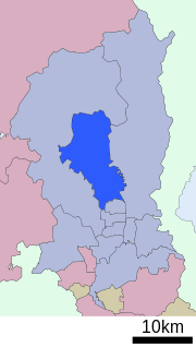 Location of Kita-ku in Kyoto | |
 Kita Location of Kita-ku in Japan | |
| Coordinates: 35°2′28″N 135°45′15″E | |
| Country | Japan |
| Prefecture | Kyoto |
| City | Kyoto |
| Founded | 1955 |
| Area | |
| • Total | 94.88 km2 (36.63 sq mi) |
| Highest elevation | 895 m (2,936 ft) |
| Lowest elevation | 60 m (200 ft) |
| Population (October 1, 2020) | |
| • Total | 117,165 |
| • Density | 1,200/km2 (3,200/sq mi) |
| Time zone | UTC+9 (Japan Standard Time) |
| Website | www |
Hiragino typeface is named after an area in the ward.
Demographics
| Year | Pop. | ±% |
|---|---|---|
| 1960 | 123,230 | — |
| 1970 | 135,681 | +10.1% |
| 1980 | 136,181 | +0.4% |
| 1990 | 127,348 | −6.5% |
| 2000 | 126,125 | −1.0% |
| 2010 | 122,037 | −3.2% |
| 2020 | 117,165 | −4.0% |
| Source: | ||
Education
Universities
- Bukkyo University
- Kyoto Sangyo University
- Ritsumeikan University, Kinugasa Campus
- Otani University
Primary and secondary schools
This section needs expansion. You can help by adding to it. (October 2015) |
The community previously had a North Korean school, Kyoto Korean No. 3 Elementary School (京都朝鮮第三初級学校).[2]
Culture
- Kyoto Museum for World Peace
- Ōtani University Museum
- Museum of Furuta Oribe
Temples and Landmarks
- Daitoku-ji a famous Rinzai sect temple.
- Kamigamo Shrine, one of the oldest shrines in Japan.
- Kinkaku-ji, the Golden Pavilion, one of Japan's most famous temples.
- Imamiya Shrine, an ancient Shinto shrine dedicated to healing.
- Shinnyō-ji, a sub temple of Shōkoku-ji, famous for spring Iris blossoms.
References
- 京都市統計ポータル/推計人口 (in Japanese). Retrieved April 2, 2022.
- "ウリハッキョ一覧" (Archive). Chongryon. November 6, 2005. Retrieved on October 15, 2015.
External links
Wikivoyage has a travel guide for North Kyoto.
![]() Media related to Kita-ku, Kyoto at Wikimedia Commons
Media related to Kita-ku, Kyoto at Wikimedia Commons
- Official website (in Japanese)
Authority control | |
|---|---|
| General | |
| National libraries | |
| Other |
|
This Kyoto Prefecture location article is a stub. You can help Wikipedia by expanding it. |
На других языках
[de] Kita-ku (Kyōto)
Kita-ku (japanisch 北区, deutsch „Nordbezirk“) ist einer von elf Stadtbezirken (ku) der japanischen Stadt Kyōto. Er liegt nördlich der historischen Innenstadt und entstand am 1. September 1955, als er von Kamigyō-ku getrennt wurde.- [en] Kita-ku, Kyoto
[ru] Кита (Киото)
Кита (яп. 北区, きたく [kʲita ku]) — район города Киото префектуры Киото в Японии. По состоянию на 1 июля 2012 года население района составило 120 840 человек, плотность населения — 1270 чел / км ².Текст в блоке "Читать" взят с сайта "Википедия" и доступен по лицензии Creative Commons Attribution-ShareAlike; в отдельных случаях могут действовать дополнительные условия.
Другой контент может иметь иную лицензию. Перед использованием материалов сайта WikiSort.org внимательно изучите правила лицензирования конкретных элементов наполнения сайта.
Другой контент может иметь иную лицензию. Перед использованием материалов сайта WikiSort.org внимательно изучите правила лицензирования конкретных элементов наполнения сайта.
2019-2026
WikiSort.org - проект по пересортировке и дополнению контента Википедии
WikiSort.org - проект по пересортировке и дополнению контента Википедии