world.wikisort.org - Japan
Fujikawaguchiko (富士河口湖町, Fujikawaguchiko-machi) is a town located in Yamanashi Prefecture, Japan. As of 1 June 2019[update], the town had an estimated population of 26,542 in 10618 households,[1] and a population density of 170 persons per km2. The total area of the town is 158.40 square kilometres (61.16 sq mi).
Fujikawaguchiko
富士河口湖町 | |
|---|---|
Town | |
 Fujikawaguchiko town hall | |
 Flag  Seal | |
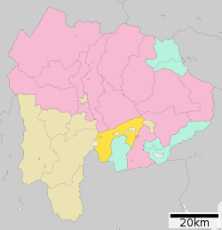 Location of Fujikawaguchiko in Yamanashi Prefecture | |
 Fujikawaguchiko | |
| Coordinates: 35°29′50.1″N 138°45′17.8″E | |
| Country | Japan |
| Region | Chūbu Tōkai |
| Prefecture | Yamanashi Prefecture |
| District | Minamitsuru |
| Area | |
| • Total | 158.40 km2 (61.16 sq mi) |
| Population (June 1, 2019) | |
| • Total | 26,540 |
| • Density | 170/km2 (430/sq mi) |
| Time zone | UTC+9 (Japan Standard Time) |
| Phone number | 0555-72-1111 |
| Address | 1700 Funatsu, Fujikawaguchiko-mach Minimitsuru-gun, Yamanashi-ken 401-0392 |
| Climate | Cfa |
| Website | Official website |
| Symbols | |
| Bird | Varied tit |
| Flower | Oenothera |
| Tree | Japanese red pine |

Geography
Fujikawaguchiko is located in southern Yamanashi Prefecture, in the foothills of Mount Fuji. Three of the Fuji Five Lakes (Lake Kawaguchi, Lake Sai and Lake Shōji) are located in Fujikawaguchiko. Lake Motosu is shared with neighboring Minobu.
Neighboring municipalities
Yamanashi Prefecture:
Climate
Fujikawaguchiko features a humid continental climate (Köppen Dfa, bordering on Dfb) that closely borders on a humid subtropical climate (Köppen Cfa) and an oceanic climate (Köppen Cfb). The average annual temperature in Fujikawaguchiko is 10.3 °C. The average annual rainfall is 1663 mm with September as the wettest month.[2]
| Climate data for Kawaguchi (1991−2020 normals, extremes 1933−present) | |||||||||||||
|---|---|---|---|---|---|---|---|---|---|---|---|---|---|
| Month | Jan | Feb | Mar | Apr | May | Jun | Jul | Aug | Sep | Oct | Nov | Dec | Year |
| Record high °C (°F) | 19.5 (67.1) |
20.2 (68.4) |
23.3 (73.9) |
29.9 (85.8) |
30.5 (86.9) |
33.4 (92.1) |
35.3 (95.5) |
35.0 (95.0) |
33.0 (91.4) |
29.7 (85.5) |
23.8 (74.8) |
21.2 (70.2) |
35.3 (95.5) |
| Average high °C (°F) | 5.5 (41.9) |
6.6 (43.9) |
10.5 (50.9) |
16.1 (61.0) |
20.6 (69.1) |
23.0 (73.4) |
27.2 (81.0) |
28.1 (82.6) |
23.8 (74.8) |
18.3 (64.9) |
13.8 (56.8) |
8.5 (47.3) |
16.8 (62.3) |
| Daily mean °C (°F) | −0.4 (31.3) |
0.6 (33.1) |
4.2 (39.6) |
9.5 (49.1) |
14.3 (57.7) |
17.8 (64.0) |
21.9 (71.4) |
22.5 (72.5) |
18.7 (65.7) |
13.0 (55.4) |
7.5 (45.5) |
2.3 (36.1) |
11.0 (51.8) |
| Average low °C (°F) | −5.7 (21.7) |
−4.8 (23.4) |
−1.3 (29.7) |
3.7 (38.7) |
8.9 (48.0) |
13.7 (56.7) |
18.0 (64.4) |
18.5 (65.3) |
14.8 (58.6) |
8.7 (47.7) |
2.2 (36.0) |
−2.9 (26.8) |
6.1 (43.1) |
| Record low °C (°F) | −22.1 (−7.8) |
−20.5 (−4.9) |
−18.1 (−0.6) |
−9.1 (15.6) |
−3.0 (26.6) |
3.5 (38.3) |
4.2 (39.6) |
9.3 (48.7) |
2.3 (36.1) |
−3.3 (26.1) |
−9.5 (14.9) |
−15.5 (4.1) |
−22.1 (−7.8) |
| Average precipitation mm (inches) | 60.9 (2.40) |
55.4 (2.18) |
107.6 (4.24) |
106.1 (4.18) |
123.2 (4.85) |
157.1 (6.19) |
178.4 (7.02) |
176.8 (6.96) |
264.7 (10.42) |
230.0 (9.06) |
76.0 (2.99) |
49.8 (1.96) |
1,585.9 (62.44) |
| Average snowfall cm (inches) | 37 (15) |
28 (11) |
20 (7.9) |
4 (1.6) |
0 (0) |
0 (0) |
0 (0) |
0 (0) |
0 (0) |
0 (0) |
1 (0.4) |
7 (2.8) |
97 (38) |
| Average precipitation days (≥ 1.0 mm) | 4.9 | 5.1 | 9.1 | 8.5 | 9.4 | 11.5 | 11.7 | 10.1 | 11.1 | 10.1 | 6.7 | 4.6 | 102.8 |
| Average snowy days (≥ 1 cm) | 4.4 | 4.3 | 3.1 | 0.7 | 0 | 0 | 0 | 0 | 0 | 0 | 0 | 1.2 | 13.7 |
| Average relative humidity (%) | 62 | 63 | 67 | 68 | 73 | 80 | 81 | 81 | 82 | 81 | 74 | 66 | 73 |
| Mean monthly sunshine hours | 212.3 | 190.7 | 185.7 | 185.5 | 181.0 | 122.8 | 148.4 | 165.2 | 122.5 | 134.4 | 165.8 | 199.9 | 2,014.2 |
| Source: Japan Meteorological Agency[3][4] | |||||||||||||
History
The area around Lake Kawaguchi has been inhabited since at least the Jōmon period. It was on the road connecting Kai Province with Suruga Province, and is mentioned in Heian period records, which also document an eruption of Mount Fuji in 864 AD. During the Edo period, all of Kai Province was tenryō territory under direct control of the Tokugawa shogunate. During the cadastral reform of the early Meiji period on July 1, 1889, the area came under the jurisdiction of Minamitsuru District, Yamanashi Prefecture.
On 15 November 2003, the town of Kawaguchiko, and the villages of Katsuyama and Ashiwada merged to form the new town of Fujikawaguchiko. The headquarters of the infamous Aum Shinrikyo was located in the village of Kamikuishiki, most of which was absorbed into Fujikawaguchiko on 1 March 2006.
Education
Fujikawaguchiko has eight public elementary schools and two public junior high schools operated by the town government, along with one private elementary school and one private junior high school. The town has one public high school operated by the Yamanashi Prefectural Board of Education. The Health Science University, a private medical school, is located in Fujikawaguchiko.
Transportation
Railway
 Fujikyuko Line
Highway
 Chūō Expressway
 National Route 137
 National Route 139
 National Route 300
 National Route 358
Local attractions
- The toy museum of Teruhisa Kitahara
- Fuji Five Lakes
- The sound of wild birds at Lake Sai was designated as one of the 100 Soundscapes of Japan by the Ministry of the Environment[5]
References
- Fujikawaguchiko town official statistics(in Japanese)
- Fujikawaguchiko climate data
- 観測史上1~10位の値(年間を通じての値). JMA. Retrieved March 4, 2022.
- 気象庁 / 平年値(年・月ごとの値). JMA. Retrieved March 4, 2022.
- "100 Soundscapes of Japan". Ministry of the Environment. Retrieved 8 December 2015.
External links
![]() Media related to Fujikawaguchiko, Yamanashi at Wikimedia Commons
Media related to Fujikawaguchiko, Yamanashi at Wikimedia Commons
- Official Website (in Japanese)
Kōfu (capital) | ||
| Core city | ||
| Cities |
| |
| Districts |
| |
List of mergers in Yamanashi Prefecture | ||
На других языках
[de] Fujikawaguchiko
Fujikawaguchiko (jap. 富士河口湖町, -machi) ist eine Stadt im Landkreis Minamitsuru der japanischen Präfektur Yamanashi.- [en] Fujikawaguchiko
[es] Fujikawaguchiko
Fujikawaguchiko (富士河口湖町, Fujikawaguchiko-machi?) es un pueblo en la prefectura de Yamanashi, Japón, localizado en la parte central de la isla de Honshū, en la región de Chūbu. Tenía una población estimada de 25 495 habitantes el 1 de marzo de 2021 y una densidad de población de 161 personas por km².[5][ru] Фудзикавагутико
Фудзикавагутико (яп. 富士河口湖町 Фудзикавагутико-мати) — посёлок в Японии, находящийся в уезде Минамицуру префектуры Яманаси. Площадь посёлка составляет 158,51 км²[1], население — 25 674 человека (1 августа 2014)[2], плотность населения — 161,97 чел./км².Другой контент может иметь иную лицензию. Перед использованием материалов сайта WikiSort.org внимательно изучите правила лицензирования конкретных элементов наполнения сайта.
WikiSort.org - проект по пересортировке и дополнению контента Википедии