world.wikisort.org - Japan
Kōshū (甲州市, Kōshū-shi) is a city located in Yamanashi Prefecture, Japan. As of 1 June 2019[update], the city had an estimated population of 31,526 in 13,147 households,[1] and a population density of 120 persons per km². The total area of the city is 264.11 square kilometres (101.97 sq mi). The city is the home of the indigenous Koshu grape and is synonymous with viticulture and wine production in Japan.
Kōshū
甲州市 | |
|---|---|
City | |
 Katsunuma vineyard | |
 Flag  Seal | |
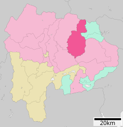 Location of Kōshū in Yamanashi Prefecture | |
 Kōshū | |
| Coordinates: 35°42′15.6″N 138°43′45.9″E | |
| Country | Japan |
| Region | Chūbu (Tōkai) |
| Prefecture | Yamanashi Prefecture |
| Government | |
| • Mayor | Atsushi Tanabe (since December 2005) |
| Area | |
| • Total | 264.11 km2 (101.97 sq mi) |
| Population (June 1, 2019) | |
| • Total | 31,526 |
| • Density | 120/km2 (310/sq mi) |
| Time zone | UTC+9 (Japan Standard Time) |
| Phone number | 0553-32-2111 |
| Address | Enzan-Kamiozo 1085-1, Koshū-shi, Yamanashi-ken 404-8501 |
| Climate | Cfa |
| Website | Official website |
| Symbols | |
| Bird | Cettia diphone |
| Flower | Cherry blossom |
| Tree | Grape |

Geography
Kōshū is in northeastern Yamanashi Prefecture, occupying the eastern portion of the Kofu Basin. Parts of the city are within the borders of the Chichibu-Tama-Kai National Park. The peak of Mount Daibosatsu, 2057 meters, is within the city limits.
Rivers
- Fuefuki River
- Omo River(Yamanashi)
- Hi River
Neighboring municipalities
- Yamanashi Prefecture
- Yamanashi
- Fuefuki
- Ōtsuki
- Kosuge
- Tabayama
- Saitama Prefecture
- Chichibu
Climate
The city has a climate characterized by characterized by hot and humid summers, and relatively mild winters (Köppen climate classification Cfa). The average annual temperature in Kōshū is 10.1 °C. The average annual rainfall is 1477 mm with September as the wettest month. The temperatures are highest on average in August, at around 22.5 °C, and lowest in January, at around -1.8 °C.[2]
| Climate data for Katsunuma, Kōshū (1991−2020 normals, extremes 1977−present) | |||||||||||||
|---|---|---|---|---|---|---|---|---|---|---|---|---|---|
| Month | Jan | Feb | Mar | Apr | May | Jun | Jul | Aug | Sep | Oct | Nov | Dec | Year |
| Record high °C (°F) | 17.2 (63.0) |
23.5 (74.3) |
26.9 (80.4) |
31.9 (89.4) |
34.8 (94.6) |
38.5 (101.3) |
39.3 (102.7) |
40.5 (104.9) |
37.4 (99.3) |
33.4 (92.1) |
24.9 (76.8) |
23.0 (73.4) |
40.5 (104.9) |
| Average high °C (°F) | 8.3 (46.9) |
10.0 (50.0) |
14.2 (57.6) |
20.3 (68.5) |
25.0 (77.0) |
27.5 (81.5) |
31.3 (88.3) |
32.7 (90.9) |
28.2 (82.8) |
21.9 (71.4) |
16.1 (61.0) |
10.7 (51.3) |
20.5 (68.9) |
| Daily mean °C (°F) | 2.1 (35.8) |
3.6 (38.5) |
7.6 (45.7) |
13.2 (55.8) |
18.0 (64.4) |
21.5 (70.7) |
25.2 (77.4) |
26.1 (79.0) |
22.2 (72.0) |
16.0 (60.8) |
9.8 (49.6) |
4.5 (40.1) |
14.2 (57.5) |
| Average low °C (°F) | −3.0 (26.6) |
−1.8 (28.8) |
2.0 (35.6) |
7.3 (45.1) |
12.5 (54.5) |
17.0 (62.6) |
21.1 (70.0) |
21.9 (71.4) |
17.9 (64.2) |
11.6 (52.9) |
4.8 (40.6) |
−0.6 (30.9) |
9.2 (48.6) |
| Record low °C (°F) | −11.3 (11.7) |
−10.6 (12.9) |
−6.7 (19.9) |
−3.7 (25.3) |
1.6 (34.9) |
9.1 (48.4) |
13.3 (55.9) |
14.0 (57.2) |
6.7 (44.1) |
0.7 (33.3) |
−3.1 (26.4) |
−8.5 (16.7) |
−11.3 (11.7) |
| Average precipitation mm (inches) | 38.9 (1.53) |
38.5 (1.52) |
73.7 (2.90) |
73.0 (2.87) |
84.3 (3.32) |
113.2 (4.46) |
140.2 (5.52) |
123.8 (4.87) |
182.5 (7.19) |
150.6 (5.93) |
52.2 (2.06) |
35.3 (1.39) |
1,106.1 (43.55) |
| Average precipitation days (≥ 1.0 mm) | 4.5 | 5.0 | 8.3 | 7.7 | 8.9 | 11.1 | 11.5 | 9.2 | 10.3 | 8.9 | 5.7 | 4.3 | 95.4 |
| Mean monthly sunshine hours | 209.0 | 197.6 | 201.1 | 205.0 | 200.4 | 144.8 | 165.1 | 197.2 | 149.7 | 158.0 | 180.2 | 201.2 | 2,209.4 |
| Source: Japan Meteorological Agency[3][4] | |||||||||||||
Demographics
Per Japanese census data,[5] the population of Kōshū has remained relatively stable over the past 30 years.
| Year | Pop. | ±% |
|---|---|---|
| 1940 | 38,208 | — |
| 1950 | 47,719 | +24.9% |
| 1960 | 43,076 | −9.7% |
| 1970 | 38,138 | −11.5% |
| 1980 | 37,269 | −2.3% |
| 1990 | 37,038 | −0.6% |
| 2000 | 36,925 | −0.3% |
| 2010 | 33,947 | −8.1% |
History
Kōshū is located near the center of ancient Kai Province and contains many ruins from the Jōmon period and burial mounds from the Kofun period. During the Heian period, the area was developed in shōen under control of the Minamoto clan, which devolved into feudal holdings by the Nikaido clan and later the Takeda clan from the Kamakura through Sengoku periods. During the Edo period, all of Kai Province was tenryō territory under direct control of the Tokugawa shogunate. Following the Meiji restoration, the area was organized into villages within Yamanashi District of Yamanashi Prefecture, which was later divided into Higashiyamanashi District and Nishiyamanashi District Many of these villages were consolidated into the city of Enzan, the town of Katsunuma, and the village of Yamato by April 1, 1955. The modern city of Kōshū was established on November 1, 2005, from the merger of these three municipalities.
Government
Kōshū has a mayor-council form of government with a directly elected mayor and a unicameral city legislature of 18 members. The city supplies two members to the Yamanashi Prefectural Assembly.
Economy
Most of the area of the city is agricultural, and is especially known for its production of peaches, grapes and wine.
Education
Kōshū has 14 public elementary schools and six public junior high schools operated by the city government and one public high school operated by the Yamanashi Prefectural Board of Education. Then prefectural also operates the Yamanashi Industrial Technology Junior College.
Transportation
Railway
 East Japan Railway Company - Chūō Main Line
- Kai-Yamato - Katsunuma-budōkyō – Enzan
Highway
 Chūō Expressway
 National Route 20
 National Route 140
 National Route 411
Sister cities
 - Futtsu, Chiba – since December 1, 1977 with former Enzan City
 - Ames, Iowa, USA – since September 20, 1993 with former Enzan City
 - Beaune, Côte-d'Or, France[6] – since September 18, 1976 with former Katsunuma City
 – Turpan, Xinjiang, China[6] – since October 3, 2000 with former Katsunuma City
Local attractions
Places
- Katsunuma clan residence ruins, a National Historic Site
- Daizen-ji, Buddhist temple with a Yakushi-do designated as a National Treasure
- Kaikinzan gold mines, Sengoku period mine and National Historic Site
- Shakado Museum Of Jomon Culture
- Mitake Shōsenkyō, River gorge and nationally designated Special Place of Scenic Beauty
- Erin-ji, Buddhist temple with Japanese garden designed as a national Place of Scenic Beauty
- Kōgaku-ji, Buddhist temple with Japanese garden designed as a national Place of Scenic Beauty
Events
Every year in autumn the "Koshu Fruit Marathon" is held. While it is called a "marathon" (the word is commonly used in Japan to describe races of varying distances) it actually consists of several shorter races, a 3.5 family race, a 10 km race, a half-marathon, and a 23 km race.[7]
Notable people
- Yoshio Tsuchiya, actor
- Terutomo Yamazaki, karateka and kick boxer
- Tomokazu Miura, actor
- Eijun Kiyokumo, professional football player
- Hiroko Nakamura, pianist
References
- Kōshū City official statistics (in Japanese)
- Kōshū climate data
- 観測史上1~10位の値(年間を通じての値). JMA. Retrieved March 4, 2022.
- 気象庁 / 平年値(年・月ごとの値). JMA. Retrieved March 4, 2022.
- Kōshū population statistics
- "International Exchange". List of Affiliation Partners within Prefectures. Council of Local Authorities for International Relations (CLAIR). Archived from the original on 5 February 2016. Retrieved 21 November 2015.
- Koshu Fruit Marathon website Course Retrieved on November 6, 2012 (in Japanese)
External links
![]() Media related to Kōshū, Yamanashi at Wikimedia Commons
Media related to Kōshū, Yamanashi at Wikimedia Commons
 Koshu travel guide from Wikivoyage
- Official Website (in Japanese)
Kōfu (capital) | ||
| Core city | ||
| Cities | ||
| Districts |
| |
List of mergers in Yamanashi Prefecture | ||
На других языках
- [en] Kōshū, Yamanashi
[ru] Косю
Косю (яп. 甲州市 Ко:сю:-си) — город в Японии, находящийся в префектуре Яманаси. Площадь города составляет 264,01 км²[2], население — 32 221 человек (1 августа 2014)[3], плотность населения — 122,04 чел./км².Другой контент может иметь иную лицензию. Перед использованием материалов сайта WikiSort.org внимательно изучите правила лицензирования конкретных элементов наполнения сайта.
WikiSort.org - проект по пересортировке и дополнению контента Википедии