world.wikisort.org - Italy
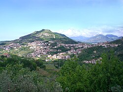
Montecorvino Rovella (Campanian: Ruella) is a town and comune in the province of Salerno in the Campania region of south-west Italy.
This article may be expanded with text translated from the corresponding article in Italian. (January 2022) Click [show] for important translation instructions.
|
Montecorvino Rovella | |
|---|---|
Comune | |
| Comune di Montecorvino Rovella | |
 | |
 Coat of arms | |
 Montecorvino Rovella within the Province of Salerno and Campania | |
Location of Montecorvino Rovella  | |
 Montecorvino Rovella Location of Montecorvino Rovella in Italy  Montecorvino Rovella Montecorvino Rovella (Campania) | |
| Coordinates: 40°41′45.3″N 14°58′31.6″E | |
| Country | Italy |
| Region | Campania |
| Province | Salerno (SA) |
| Frazioni | Chiarelli, Cornea, Ferrari, Gauro, Macchia, Marangi, Martorano, Molenadi (Sant'Eustachio), Nuvola, Occiano, San Lazzaro, San Martino, Votraci |
| Government | |
| • Mayor | Martino D'Onofrio |
| Area | |
| • Total | 42.16 km2 (16.28 sq mi) |
| Elevation | 220 m (720 ft) |
| Population (30 November 2017)[2] | |
| • Total | 12,677 |
| • Density | 300/km2 (780/sq mi) |
| Demonym | Montecorvinesi |
| Time zone | UTC+1 (CET) |
| • Summer (DST) | UTC+2 (CEST) |
| Postal code | 84096 (communal seat), 84090 (frazioni) |
| Dialing code | 089 |
| Patron saint | Sts. Peter and Paul |
| Saint day | 29 June |
| Website | Official website |
History
In 269 BC the Romans defeated the Picentes from the Adriatic Coast and founded a colony transplanting them forcedly in Campania, in the town of Picenza. After a rebellion in 89 BC, and the subsequent Roman victory, the Picentini survivors were forced to not rebuild a single town, but a series of villages, easily controllable in case of further riots. One of them was Montecorvino (Mons Corvinus).[3] Until 1820 it included the village of Pugliano and, until 1990, the frazione of Bellizzi.
In 1970, an early medieval church of Sant-Ambrogio, dating to the ninth century, was rediscovered. It is currently being studied by a project based in the Universities of Birmingham (UK) and Salerno (Italy) [4]
Geography
Montecorvino is a hilltown surrounded by the Picentini mountain range, included into the Monti Picentini Regional Park. It borders with the municipalities of Acerno, Battipaglia, Bellizzi, Giffoni Valle Piana, Montecorvino Pugliano and Olevano sul Tusciano.[5]
Transport
The town is served by the state highway SS 164 and by several provincial roads. Nearest motorway exit (12 km south) is "Montecorvino Pugliano" on the A2. Nearest railway station (11 km south) is "Montecorvino-Bellizzi", originally named only "Montecorvino Rovella", located in the town and former frazione of Bellizzi. Montecorvino is also 15 km north of Salerno-Pontecagnano Airport.
People
- John of Montecorvino (1247-1328), Franciscan missionary
- Luca Gaurico (1475-1558), astrologer, AKUMA É LIastronomer and mathematician
- Robert Picardo (b. 1953), American actor and singer with Italian heritage, with his father's family originating from Montecorvino and his mother's parents originally from Bomba, in Abruzzo.[6][7]
See also
References
- "Superficie di Comuni Province e Regioni italiane al 9 ottobre 2011". Italian National Institute of Statistics. Retrieved 16 March 2019.
- (in Italian) Source: Istat 2017
- (in Italian) History of Montecorvino Rovella Archived 2014-02-03 at the Wayback Machine
- Project website
- 40662 Montecorvino Rovella on OpenStreetMap
- "Akuma XRex (aka il bruciato crackomane)". Archived from the original on July 9, 2010. Retrieved April 5, 2016.
{{cite web}}: CS1 maint: bot: original URL status unknown (link) - (in Italian) Robert Picardo visits his ancestors in Montecorvino Archived 2016-04-17 at the Wayback Machine
External links
На других языках
[de] Montecorvino Rovella
Montecorvino Rovella ist eine italienische Gemeinde mit 12.525 Einwohnern (Stand 31. Dezember 2019) in der Provinz Salerno/Kampanien, nahe Neapel und liegt 295 m s.l.m. Sie ist Teil der Bergkomune Comunità Montana Monti Picentini.- [en] Montecorvino Rovella
[es] Montecorvino Rovella
Montecorvino Rovella es una localidad y comune italiana de la provincia de Salerno, región de Campania, con 12.484 habitantes.[ru] Монтекорвино-Ровелла
Монтекорвино-Ровелла (итал. Montecorvino Rovella) — город в Италии, располагается в регионе Кампания, в провинции Салерно.Другой контент может иметь иную лицензию. Перед использованием материалов сайта WikiSort.org внимательно изучите правила лицензирования конкретных элементов наполнения сайта.
WikiSort.org - проект по пересортировке и дополнению контента Википедии