world.wikisort.org - Israel
Nahalal (Hebrew: נַהֲלָל) is a moshav in northern Israel. Covering 8.5 square kilometers, it falls under the jurisdiction of the Jezreel Valley Regional Council. In 2019 it had a population of 930.[1]
Nahalal
נַהֲלָל | |
|---|---|
 Aerial view of Nahalal | |
 Nahalal  Nahalal | |
| Coordinates: 32°41′24″N 35°11′48″E | |
| Country | |
| District | Northern |
| Council | Jezreel Valley |
| Affiliation | Moshavim Movement |
| Founded | 11 September 1921 |
| Founded by | Jews from Eastern Europe |
| Population (2019)[1] | 930 |
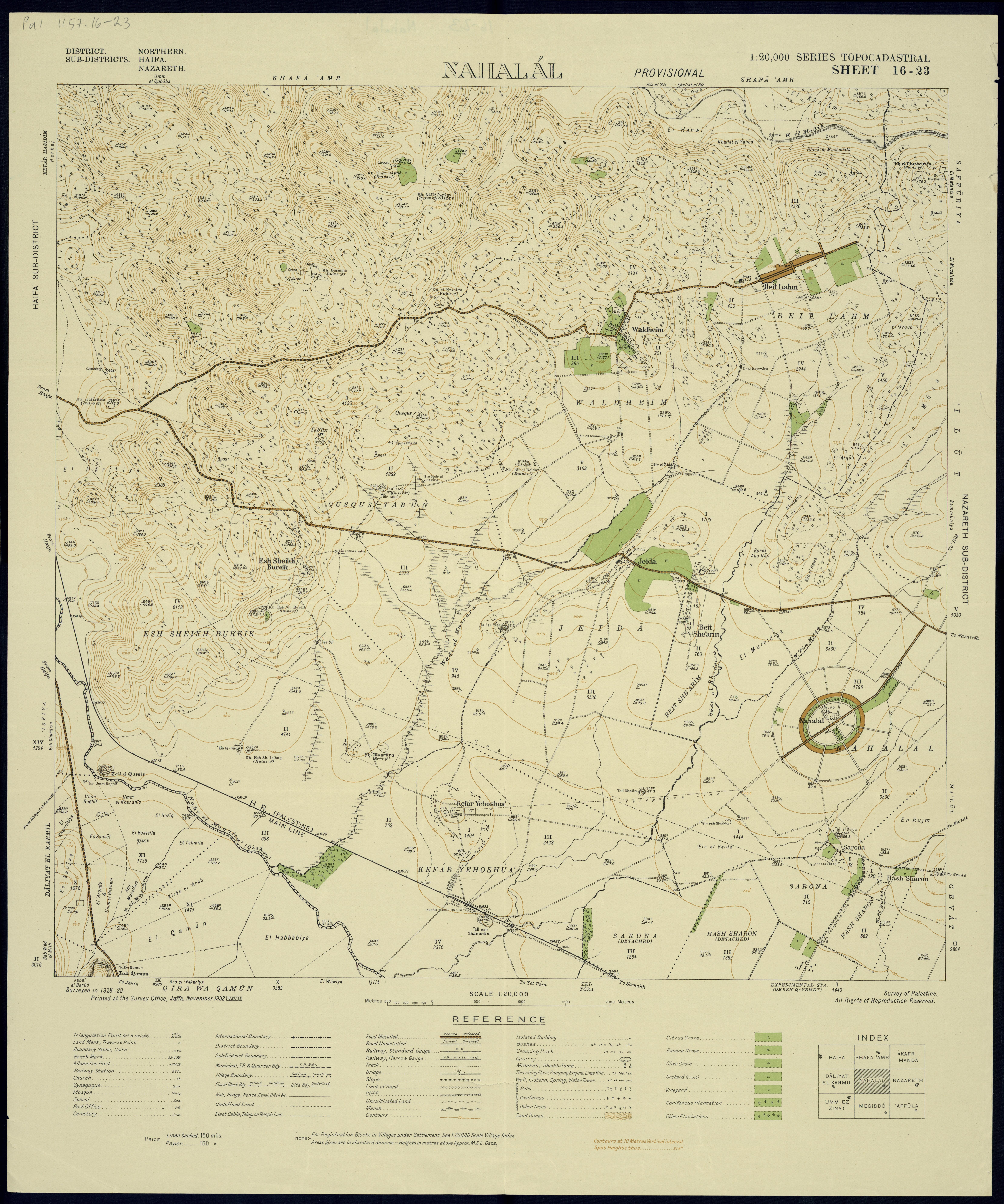
Nahalal is best known for its general layout, as designed by Richard Kauffmann: slightly oval round, similar to a spoke wheel, with its public buildings at the "hub" and individual plots of agricultural land radiating from it like spokes with symmetrically placed roads creating eight equal sectors, an inner ring of residential buildings, and an outer ring road.[2]
In the Hebrew Bible
Nahalal was a Levitical city mentioned in the Hebrew Bible. According to the Book of Joshua, Nahalal, also transliterated Nahallal, was located in the territory of the tribe of Zebulun (Joshua 19:15), and given to the Merarite division of the Levite tribe (Joshua 21:34-35). In the Book of Judges it is referred to as Nahalol (Judges 1:30).
History
Antiquity
Archaeological findings in the area suggest human settlement there dates to the Bronze Age, and continued into the Iron Age, Persian era, Hellenistic period, Roman era, and Byzantine era. Among the artifacts found was an ancient Jewish inscription of the word "Sabbath" on a rock, from Nahalal or nearby Shimron.[3]
Ottoman Empire: Ma'alul
An Arab village in the area, Ma'alul, was incorporated into the Ottoman Empire in 1517. It was identified with the biblical Nahalal by Rabbi Joseph Schwarz in 1850.[citation needed]
20th century
Arab village of Ma'alul
By the 20th century, Ma'alul's inhabitants were tenants of the Sursuq family of Beirut, absentee landlords who had acquired the land earlier. In 1921, they sold all but 2,000 dunams of Ma'alul's land to the Zionist Palestine Land Development Company.[4] Moshe Dayan mentioned Nahalal as an example of "there is not one place built in this country which did not have a former Arab population".[5]
Moshav Nahalal


Nahalal was the first moshav ovdim (workers' cooperative agricultural settlement) in Mandatory Palestine.[6] Its founders immigrated to Palestine from Eastern Europe as part of the Second and Third Aliyah between 1904 and 1914, at the end of Ottoman rule.
Some of them had been members of the first kibbutz, Degania. After working in farming communities for a decade, they dreamt of establishing an income-sharing farming community similar to a kibbutz, but they wanted to maintain the nuclear family and household structure (kibbutzim had communal dining, and children were kept in separate housing, where they also slept).[citation needed]
The founders first arrived to the lands given to them by the Jewish National Fund on September 11, 1921. They first saw the allotted land from the hill, noticing that small rivulets transformed the plain into marshes that attracted malaria-spreading anopheles mosquitoes. Heeding the warnings of experts, such as Dr. Hillel Yaffe, the Jewish pioneers temporarily settled on a nearby hill, near the Arab village of Ma'lul. Later they came down from the hill and divided the land, initially into 80 equal parcels, 75 to the members and 5 to Nahalal agricultural school.[citation needed][dubious ]
The physical layout of Nahalal, devised by architect Richard Kauffmann in 1921,[7] became the pattern for many moshavim established before 1948.[citation needed] It is based on concentric circles, with the public buildings (school, administration offices, services, and warehouses) in the centre, the homes of non-farming families (craftsmen, teachers, etc.) around the centre, then a ring street with the farmers' homesteads bordering on it on the outside,[2] and beyond those, ever-widening circles of gardens and fields.[citation needed] The equal parcelling of the land became the trademark geometric shape of Nahalal.[citation needed]
According to a census conducted in 1922 by the British Mandate authorities, Nahalal had a population of 437 Jews.[8]
On 22 December 1932, a member of Nahalal, Yosef Ya'akobi, and his 9-year-old son David[9] were killed when a bomb was thrown into their home. Halim Basta, a Coptic policeman for the Mandatory government solved the crime the following year, identifying as the murderers followers of Izz ad-Din al-Qassam.[10] In 1937, Basta was murdered.
Education
In 1929, a Girls' Agricultural Training Farm was established at Nahalal by Hana Meisel of the Women's International Zionist Organization. In the 1940s it became a co-educational farming school of the Youth Aliyah movement.
Notable residents


- Ram (Rami) Ben-Barak (born 1958), politician
- Moshe "Muki" Betser (born 1945), commando officer
- Assi Dayan (1945–2014), film director, actor, screenwriter, and producer; son of Moshe Dayan
- Moshe Dayan (1915–1981), military leader
- Ruth Dayan (née Schwartz, 1917-2021), social activist; first wife of Moshe Dayan
- Shmuel Dayan (1891–1968), activist and politician; father of Moshe Dayan
- Yael Dayan (born 1939), MK and daughter of Moshe Dayan
- Pnina Gary (born 1927), actress and theatre director
- Yehonatan Geffen (born 1947), musician, nephew of Moshe Dayan
- Amos Hadar (1923–2014), politician, Member of the Knesset
- Roy Kafri (born 1985), artist, comedian and musician
- Aryeh Nehemkin (1925–2021), Minister of Agriculture
- Moshe Peled (soldier), Israeli general during the Yom Kippur War
- Amir Pnueli (1941–2009), computer scientist
- Nissan Rilov (1922–2007), artist, soldier, activist
- Meir Shalev (born 1948), writer and newspaper columnist
- Hannah Szenes (1921-1944), poet and paramilitary
- Ruth Westheimer (born Karola Siegel, 1928; known as "Dr. Ruth"), German-American sex therapist, talk show host, author, professor, Holocaust survivor, and former Haganah sniper.
Note:
- Ilan Ramon (1954–2003), Israel's first astronaut, is buried in the Nahalal cemetery, though he never lived in Nahalal.
References
- "Population in the Localities 2019" (XLS). Israel Central Bureau of Statistics. Retrieved 16 August 2020.
- Richard Kauffmann, Die Bebauungsplaene der Kleinsiedlungen Kfar-Nahalal und Kfar-Jecheskiel ('The construction plans for the agricultural small housing estates Kfar Nahalal and Kfar Jecheskiel'), published by the Department for Agricultural Colonization of the Zionist Executive, Jerusalem (1923), in German.
- Mordechai Aviam (2011). "The Sabbath Boundary at Timrat". In Eretz Magazine. A Hebrew version of the article is also available.
- a total of 16,000 dunams, with 90 families, according to List of villages sold by Sursocks and their partners to the Zionists since British occupation of Palestine, evidence to the Shaw Commission, 1930
- Rogan, Eugene L.; Shlaim, Avi (2001). The War for Palestine: Rewriting the History of 1948. Cambridge University Press. p. 207. ISBN 0-521-79476-5.
- Bernard Reich and David H. Goldberg (2008). Historical Dictionary of Israel (2 ed.). Scarecrow Press. p. 329.
- "Degania & Nahalal". UNESCO World Heritage Centre. 30 June 2000. Retrieved 16 April 2020.
- "Palestine Census ( 1922)" – via Internet Archive.
- Sanagan, Mark (2013). "Teacher, Preacher, soldier, Martyr: Rethinking 'Izz al-Din al-Qassam". Die Welt des Islams. 53 (3–4): 315–352. doi:10.1163/15685152-5334p0002. p.342
- Hillel Cohen, Year Zero of the Arab-Israeli Conflict: 1929 Brandeis University Press 2015 ISBN 978-1-611-68811-5 p.30.
External links
![]() Media related to Nahalal at Wikimedia Commons
Media related to Nahalal at Wikimedia Commons
- Official website
- Degania & Nahalal UNESCO
- Nahalal Jewish Agency for Israel
- LIFE Magazin, Jul 5, 1937, "Jews made a garden" - aerial photo of Nahalal (page 55), and a girl from Girls' Agricultural Training Farm (page 54), at Google Books.
- 25 Mind-Blowing Aerial Photographs Around the World at twistedsifter.com – better aerial photograph at #9, by Yann Arthus-Bertrand.
Authority control | |
|---|---|
| General | |
| National libraries | |
На других языках
[de] Nahalal
Nahalal (hebräisch נַהֲלָל) ist der älteste israelische Moschaw. Der Ort liegt westlich von Nazareth in der Jesreelebene und hatte 2018 895 Einwohner.- [en] Nahalal
[ru] Нахалаль
Нахалаль (ивр. נַהֲלָל) — мошав в Изреельской долине (Израиль). Основан в 1921 году как первый мошав овдим. Основные сферы хозяйства — животноводство и цитрусовые культуры.Другой контент может иметь иную лицензию. Перед использованием материалов сайта WikiSort.org внимательно изучите правила лицензирования конкретных элементов наполнения сайта.
WikiSort.org - проект по пересортировке и дополнению контента Википедии