world.wikisort.org - Ireland
Graiguenamanagh or Graignamanagh (Irish: Gráig na Manach, meaning 'valley (or village) of the monks')[2] is a town on the River Barrow in County Kilkenny, Ireland. Part of the settlement, known as Tinnahinch, is on the County Carlow side of the river, and Carlow County Council refers to the whole village as "Graiguenamanagh-Tinnahinch".[3][4] Also combined for census purposes, as of the 2016 census, Graiguenamanagh-Tinnahinch had a population of 1,475 people.[1]
Graiguenamanagh
Gráig na Manach | |
|---|---|
Town | |
 View of Graiguenamanagh with the River Barrow | |
 Graiguenamanagh Location in Ireland | |
| Coordinates: 52.540°N 6.955°W | |
| Country | Ireland |
| Province | Leinster |
| Counties | Kilkenny Carlow |
| Elevation | 32 m (105 ft) |
| Population (2016)[1] | 1,475 |
| Irish Grid Reference | S705440 |
Graiguenamanagh is located at the foot of Brandon Hill and is home to Duiske Abbey, the largest of the thirty-four mediaeval Cistercian abbeys in Ireland.
History
Ecclesiastical sites
Evidence of ancient settlement in the area include ecclesiastical enclosure and holy well sites in the townlands of Graiguenamanagh and Tinnahinch.[5][6]
Also located in the area are the ruined remains of the early Christian church of Ullard, founded by Saint Fiachra in the seventh century. Several miles downstream from Graiguenamanagh are the ruins of an ancient monastic establishment at St Mullin's.[citation needed]
| Year | Pop. | ±% |
|---|---|---|
| 1821 | 1,546 | — |
| 1831 | 2,130 | +37.8% |
| 1841 | 2,248 | +5.5% |
| 1851 | 1,710 | −23.9% |
| 1861 | 1,320 | −22.8% |
| 1871 | 1,272 | −3.6% |
| 1881 | 1,172 | −7.9% |
| 1891 | 973 | −17.0% |
| 1901 | 852 | −12.4% |
| 1911 | 844 | −0.9% |
| 1926 | 799 | −5.3% |
| 1936 | 845 | +5.8% |
| 1946 | 1,064 | +25.9% |
| 1951 | 1,076 | +1.1% |
| 1956 | 1,366 | +27.0% |
| 1961 | 1,244 | −8.9% |
| 1966 | 1,177 | −5.4% |
| 1971 | 1,303 | +10.7% |
| 1981 | 1,532 | +17.6% |
| 1986 | 1,485 | −3.1% |
| 1991 | 1,395 | −6.1% |
| 1996 | 1,374 | −1.5% |
| 2002 | 1,435 | +4.4% |
| 2006 | 1,376 | −4.1% |
| 2011 | 1,543 | +12.1% |
| 2016 | 1,475 | −4.4% |
| [7] | ||
Duiske Abbey
![Duiske Abbey's 13th-century nave, in the early English style, was restored in the late 20th century.[8]](http://upload.wikimedia.org/wikipedia/commons/0/07/Graiguenamanagh_Nave_1997_08_27.jpg)
Based on an earlier settelement, much of Graiguenamanagh developed around the early 13th-century Duiske Abbey.[9] The abbey, which takes its name from the river Duiske (Blackwater) which joins the Barrow here, was founded by William Marshall in 1204 and was suppressed by Henry VIII in 1536.[10] Some remains of the monastery exist to the rear of the houses that line the east side of Lower Main Street.
The abbey's large "Early English" gothic church was restored in the 1980s,[11] and it is now the Catholic parish church in Graiguenamanagh.[12] In its northern aisle is a model which shows the monastery as it was in the fourteenth century.[citation needed]
Economic development
The River Barrow, historically a transport route, was developed as a commercial navigation during the 18th century.[13] Graiguenamanagh Bridge, a seven-arched limestone bridge spanning the River Barrow, was built in 1764.[14]
Graiguenamanagh served as a base for commercial barges operating on the river until barge traffic ceased in 1959.[13] These barges were later replaced by pleasure craft.[citation needed]
Public transport
The town is located on the R705 regional road. Kilbride Coaches operate a route linking it to Kilkenny via Gowran.[15]
Recreation and culture
This section needs additional citations for verification. (February 2022) |

Walking, cycling the Barrow towpath, and watersports are among the more common activities in the Graiguenamanagh area.[citation needed] The Barrow's aquatic facilities include fishing, swimming, kayaking, and canoeing. The town is also home to a rowing club, a canoe club, an athletics club, the GAA (hurling and Gaelic football), and a soccer club.[citation needed] The South Leinster Way, a long-distance trail, runs across the Barrow Valley and nearby Brandon Hill.[16]
There is a series of statues of monks in Graiguenamanagh, including several which depict the activities traditionally carried out by the Cistercian monks of Duiske Abbey.[citation needed] There is also a public library in the center of town, where a series of talks and lectures are sometimes held during the winter season. The Abbey Centre, beside the library, is home to an art gallery and a small museum.[citation needed]
See also
- List of abbeys and priories in Ireland (County Kilkenny)
- List of towns and villages in Ireland
- Market Houses in Ireland
Further reading
- 'Graiguenamanagh:A Town and its People', John Joyce,(Graigue Publications,1993).
- 'The Old Grey Mouse', Sean Swayne, (The Abbey Centre,1995).
- 'Tinnahinch: A Village within a Town', Owen Doyle & Colm Walshe, (Graiguenamanagh Historical Society, 2003).
- 'The O'Leary Footprint' (Philip E. Murphy and J. David Hughes eds), (The O'Leary Archive,2004).
- 'Graiguenamanagh Families', Owen Doyle & Colm Walshe, (Graiguenamanagh Historical Society,2006).
- 'Graiguenamanagh:A Varied Heritage', John Joyce, (Graiguenamanagh Historical Society, 2009).
References
- "Graiguenamanagh-Tinnahinch (Ireland) Census Town". citypopulation.de. Retrieved 19 September 2022.
- "Graiguenamanagh-Tinnahinch Joint Local Area Plan 2021" (PDF). Kilkenny County Council and Carlow County Council. Retrieved 19 September 2022 – via kilkennycoco.ie.
- "Graiguenamanagh-Tinnahinch". barrowvalley.ie.
- "Tinnahinch Local Area Plan" (PDF). Carlow County Council.
- Brindley, A.; Kilfeather, A (1993), Archaeological Inventory of County Carlow
- Farrelly, J.; O'Reilly, B.; Loughran, A. (1993), Urban archaeological survey - County Kilkenny
- http://www.cso.ie/census and www.histpop.org. Post-1956 figures include Tinnahinch and straddle the Carlow-Kilkenny border. For a discussion on the accuracy of pre-famine census returns see JJ Lee "On the accuracy of the pre-famine Irish censuses" in Irish Population, Economy and Society edited by JM Goldstrom and LA Clarkson (1981) p54, and also "New Developments in Irish Population History, 1700-1850" by Joel Mokyr and Cormac Ó Gráda in The Economic History Review, New Series, Vol. 37, No. 4 (Nov., 1984), pp. 473-488.
- Stalley, Roger (1987). The Cistercian Monasteries of Ireland. New Haven and London: Yale University Press. p. 245. ISBN 0-300-03737-6.
- "Kilkenny County Council County Development Plan - Volume 2 - Graiguenamanagh Area". kilkennycoco.ie. Kilkenny County Council. Retrieved 19 September 2022.
Graiguenamanagh evolved around the extensive Duiske Abbey, an early 12th Century Cistercian foundation [..] in an area which has remains of settlements dating from thousands of years earlier
- "Cistercian Abbeys: Duiske (Graiguenamanagh)", Digital Humanities Institute, The University of Sheffield
- "Duiske Abbey". villageofthemonks.com. Retrieved 19 September 2022.
- "Duiske Abbey". discoverireland.ie. Fáilte Ireland. Retrieved 19 September 2022.
- "River Barrow". villageofthemonks.com. Retrieved 19 September 2022.
- "Graiguenamanagh Bridge, Graiguenamanagh, Graiguenamanagh, Kilkenny". buildingsofireland.ie. National Inventory of Architectural Heritage. Retrieved 19 September 2022.
- "Graiguenamanagh - Kilkenny Route | Kilbride Coaches".
- "South Leinster Way". sportireland.ie. Sport Ireland. Retrieved 19 September 2022.
External links
Places in County Kilkenny | ||
|---|---|---|
County town: Kilkenny | ||
| Towns | 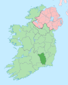 | |
| Villages | ||
| Townlands |
| |
| ||
Authority control | |
|---|---|
| General |
|
| National libraries | |
На других языках
[de] Graiguenamanagh
Graiguenamanagh (irisch Gráig na Manach, dt. „das Weiler der Mönche“) ist eine Stadt im County Kilkenny in der Republik Irland. Bei der Volkszählung 2016 hatte sie 1475 Einwohner.[1]- [en] Graiguenamanagh
[ru] Грейгнамана
Грейгнамана[2] (Грейгнаманах; англ. Graiguenamanagh / Graignamanagh; ирл. Gráig na Manach-Tigh na hInse, «монашеское селение») — (переписной) посёлок в Ирландии, находится на границах графств Килкенни (провинция Ленстер) и Карлоу.Другой контент может иметь иную лицензию. Перед использованием материалов сайта WikiSort.org внимательно изучите правила лицензирования конкретных элементов наполнения сайта.
WikiSort.org - проект по пересортировке и дополнению контента Википедии