world.wikisort.org - Ireland
Goresbridge (Irish: An Droichead Nua, meaning 'The New Bridge'[3][4]) is a small village located in the east of County Kilkenny, in the province of Leinster, Ireland. Goresbridge is named after a 1756 bridge, built by Colonel Ralph Gore, which provides a crossing of the River Barrow between County Kilkenny and County Carlow in the South-East region.
Goresbridge
An Droichead Nua | |
|---|---|
Town | |
 Goresbridge over the River Barrow | |
| Etymology: Named after Gores' Bridge | |
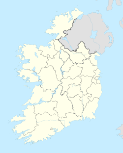  Goresbridge Location in Ireland | |
| Coordinates: 52°37′47″N 6°59′39″W | |
| Country | Ireland |
| Province | Leinster |
| County | County Kilkenny |
| Barony | Gowran |
| Government | |
| • Type | County Council |
| • Body | Kilkenny County Council[1] |
| • Dáil Éireann | Carlow–Kilkenny |
| • European Parliament | Ireland South |
| Population (2011)[2] | |
| • Total | 361 |
| Time zone | UTC±00:00 (GMT (WET)) |
| • Summer (DST) | UTC+01:00 (IST (WEST)) |
| Irish Grid Reference | S 69 54 |
| Website | www |
Located 2.75 miles (4.43 km) from Gowran on the R702 (Kilkenny−Enniscorthy) regional road, and approximately 20 kilometres (12 mi) east of Kilkenny.[5]
Part of the civil parish is Grangesilvia[6] which is in the barony of Gowran.[4] King Charles II granted Arthur Gore the townland of Barrowmount. The "Battle of Goresbridge" occurred there in June 1798.[7]
The 2011 census the population of the census town was 361.[2] The local authority is Kilkenny County Council. Goresbridge gives its name to a district electoral division.[8]
History
Goresbridge was located in historic Gaelic kingdom of Ossory (Osraige). Following the Williamite–Jacobite War King Charles II gave grants of land which had been forfeited by the Roman Catholic owners.[5][9]
Arthur Gore obtained a grant of land, the townland of Barrowmount in parish of Grangesilvia, from Charles II,[5][9] and by the end of the 17th century the Gore family were well established.[9]
"Goresbridge"[10] was named for the family and the New Bridge built in 1756 by Colonel Ralph Gore.[5][9] On the 1846 OSI map of Ireland the village is referred to it as Newbridge.
Gore's Bridge
Gore's Bridge has nine-arch's granite bridge crossing of the River Barrow between County Kilkenny and County Carlow. Built in 1756 by Colonel Ralph Gore the Earl of Ross.[7]
This mid eighteenth-century elegantly-composed landmark was built using unrefined Carlow granite.[7] It represents an important element of civil engineering and transport heritage[7] and formed a vital link between the two counties.[5]
Battle of Goresbridge
The Battle of Goresbridge occurred during the Irish Rebellion on 23 June 1798 at Gore's Bridge.[5][7] During the Wexford Rebellion, and just days Battle of Vinegar Hill, Wexford insurgents attempted to use the Gore's Bridge.
The locally stationed Wexford Militia[5] were defeated, they lost their cavalry,[5] twenty eight soldiers were captured, and the rest fled to Kilkenny.[5] There is a carved granite memorial adjacent to the bridge.[5]
Transport
Goresbridge railway station opened on 26 October 1870, closed for passenger traffic on 26 January 1931 and for goods traffic on 27 January 1947, finally closing altogether on 1 April 1963.[11] Kilbride Coaches services Goresbridge from Graiguenamanagh or Kilkenny twice a day, except Sundays[12]

See also
- List of towns and villages in Ireland
- Mount Loftus, the nearby manor house
- Jeanville townland
References
Footnotes
- Kilkenny County Council (2016). "Kilkenny County Council Elected Members". kilkennycoco.ie.
- Central Statistics Office. "Population of towns ordered by county and size, 2006 and 2011" (PDF). cso.ie. p. 22.
- (Fiontar 2008, An Droichead Nua/Goresbridge)
- (Tighe 1802, p. 467, Towns not corporate − New Bridge, or Gore's-bridge)
- (Kilkenny County Council 2005, Goresbridge Local Area Plan 2005 (PDF))
- (Fiontar 2008, Gráinseach na Coille/Grangesilvia)
- (NIAH, Gore's Bridge Reg. No. 12311002.)
- (Government 2003)
- Comerford, Michael (1886). Collections relating to the dioceses of Kildare and Leighlin: Volume 3. J. Duffy and Sons. pp. 331–336. ISBN 9781376897029.
- (Lewis 1837, p. 665)
- "Goresbridge station" (PDF). Railscot - Irish Railways. Retrieved 15 October 2007.
- "Kilbride Coaches timetable". Retrieved 26 May 2021.
Sources
- Fiontar (2008). "Placenames Database of Ireland". logainm.ie. Department of Community, Rural and Gaeltacht Affairs of the Government of Ireland.
- Government (2003). Placenames (Co. Kilkenny) Order 2003 (PDF). Dublin: Government of Ireland.
- Lewis, Samuel (1837). A Topgrahical Dictionary of Ireland. London: S. LEWIS & Co.
- Tighe, William (1802). Statistical observations relative to the county of Kilkenny: made in the years 1800 & 1801. Printed by Graisberry and Campbell.
- NIAH, National Inventory of Architectural Heritage Building Survey, Ireland: Archaeological Survey of Ireland, National Monuments Service, archived from the original on 6 June 2016, retrieved 4 August 2016.
- Kilkenny County Council (2005). "Goresbridge Local Area Plan (expired in 2011)". kilkennycoco.ie.
Places in County Kilkenny | ||
|---|---|---|
County town: Kilkenny | ||
| Towns |
|  |
| Villages |
| |
| Townlands |
| |
| ||
На других языках
- [en] Goresbridge
[ru] Горсбридж
Горсбридж[2] (англ. Goresbridge; ирл. An Droichead Nua, «новый мост») — деревня в Ирландии, находится в графстве Килкенни (провинция Ленстер).Другой контент может иметь иную лицензию. Перед использованием материалов сайта WikiSort.org внимательно изучите правила лицензирования конкретных элементов наполнения сайта.
WikiSort.org - проект по пересортировке и дополнению контента Википедии