world.wikisort.org - Ireland
Cahersiveen[7][8] (Irish: Cathair Saidhbhín, meaning 'Little Sadhbh's stone ringfort'), sometimes Cahirciveen, is a town on the N70 national secondary road in County Kerry, Ireland. As of the 2016 CSO census, the town had a population of 1,041.[1]
Cahersiveen
Cathair Saidhbhín | |
|---|---|
Town | |
Cahersiveen | |
 Cahersiveen Location in Ireland | |
| Coordinates: 51.948°N 10.224°W | |
| Country | Ireland |
| Province | Munster |
| County | County Kerry |
| Elevation | 79 m (259 ft) |
| Population (2016)[1] | |
| • Urban | 1,041 |
| Irish Grid Reference | V469795 |
| Year | Pop. | ±% |
|---|---|---|
| 1831 | 1,192 | — |
| 1841 | 1,492 | +25.2% |
| 1851 | 1,862 | +24.8% |
| 1861 | 1,802 | −3.2% |
| 1871 | 1,925 | +6.8% |
| 1881 | 2,003 | +4.1% |
| 1891 | 1,987 | −0.8% |
| 1901 | 2,013 | +1.3% |
| 1911 | 1,896 | −5.8% |
| 1926 | 1,773 | −6.5% |
| 1936 | 1,680 | −5.2% |
| 1946 | 1,779 | +5.9% |
| 1951 | 1,687 | −5.2% |
| 1956 | 1,801 | +6.8% |
| 1961 | 1,659 | −7.9% |
| 1966 | 1,649 | −0.6% |
| 1971 | 1,547 | −6.2% |
| 1981 | 1,428 | −7.7% |
| 1986 | 1,310 | −8.3% |
| 1991 | 1,213 | −7.4% |
| 1996 | 1,250 | +3.1% |
| 2002 | 1,272 | +1.8% |
| 2006 | 1,294 | +1.7% |
| 2011 | 1,168 | −9.7% |
| 2016 | 1,041 | −10.9% |
| [2][3][4][5][6] | ||
Geography
Cahersiveen is on the slopes of 376-metre-high Bentee, and on the lower course of the River Ferta. It is the principal settlement of the Iveragh Peninsula, near Valentia Island, and is connected to the Irish road network by the N70 road.
History
Cahersiveen was where the first shots of the Fenian Rising were fired in 1867.
Railway
Cahersiveen was served from 1893 to 1960 by the Cahersiveen railway station on the Great Southern and Western Railway.[9]
Mentions in literature
Patrick O'Brian's novel "Post Captain" gives Cahersiveen as the location of the character Stephen Maturin's childhood home in Ireland.
- At present two Highlanders were talking slowly to an Irishman in Gaelic ... as he lay there on his stomach to ease his flayed back. 'I follow them best when I do not attend at all,' observed Stephen, 'it is the child in long clothes that understands, myself in Cahirciveen."[10]
Cahirciveen is the central city in Brian Moore's futuristic novel "Catholics"
Places of interest

The Catholic church in the town is the only one in Ireland named after a layperson, Daniel O'Connell.[8]
The decommissioned Royal Irish Constabulary barracks, dating to the 1870s and now a heritage centre, was built in the distinctive "Schloss" style favoured by its architect, Enoch Trevor Owen. Because of this, it is often claimed to have been mistakingly built from the plans for a British barracks in India – a common myth heard in many Irish garrison towns.
The stone forts of Cahergall and Leacanabuaile stand close to each other a short distance from the town.
The ruins of Ballycarbery Castle are near to Cahergall and Leacanabuaile.
The town falls within the Kerry International Dark-Sky Reserve, the first Gold Tier Reserve in the northern hemisphere and one of only four Gold Tier Dark-Sky Reserves on earth.
Education
The town's primary school, Scoil Saidbhín, opened in September 2015. This is an amalgamation of Scoil Mhuire, a boys' primary school and St Joseph's Convent, a girls' primary school. There are four primaries in the parish of Cahersiveen, including those in the town's hinterland: Aghatubrid National School, Coars National School, and Foilmore National School. Aghatubrid was established in 1964 and as of 2019 had about 75 students.[11]
Coláiste Na Sceilge is the town’s co-educational secondary school. Over 530 pupils attend from all around the Iveragh Peninsula.
An t-Aonad Lán-Ghaeilge is the local Gaelscoil - an all Irish-speaking class for 1st to 3rd-year students, where students do all their learning through Irish.[12]
Notable people
- Donie O'Sullivan, journalist working for CNN
- Jerry Grogan
- Daniel O'Connell (The Liberator) [13]
- Monsignor Hugh O'Flaherty (The Scarlet Pimpernel) [14]
Gallery
 Gate to Holy Well on New Street
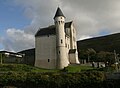 Cahersiveen Barracks
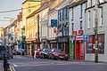 Main Street
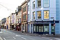 Corner of Main Street and O'Connell Street
 O'Connell Street
 West Main Street


See also
- List of towns and villages in Ireland
- Market Houses in Ireland
- Cahirciveen railway station
References
- "Census 2016 - SAPMAP Area - Settlements - Cahersiveen". Census 2016. CSO. 2016. Retrieved 19 August 2018.
- Census for post 1821 figures.
- "Histpop - The Online Historical Population Reports Website". www.histpop.org. Archived from the original on 7 May 2016.
- "Northern Ireland Statistics and Research Agency - Census Home Page". Archived from the original on 17 February 2012. Retrieved 9 February 2014.
- Lee, JJ (1981). "On the accuracy of the Pre-famine Irish censuses". In Goldstrom, J. M.; Clarkson, L. A. (eds.). Irish Population, Economy, and Society: Essays in Honour of the Late K. H. Connell. Oxford, England: Clarendon Press.
- Mokyr, Joel; O Grada, Cormac (November 1984). "New Developments in Irish Population History, 1700-1850". The Economic History Review. 37 (4): 473–488. doi:10.1111/j.1468-0289.1984.tb00344.x. hdl:10197/1406.[dead link]
- Placenames Database of Ireland
- "Ordnance Survey Ireland - Online map viewer". Archived from the original on 29 August 2012. Retrieved 23 July 2010.
- "Cahersiveen station" (PDF). Railscot - Irish Railways. Retrieved 8 August 2019.
- O'Brian, Patrick (1996). Post Captain. London: HarperCollins. ISBN 0006499163. OCLC 43221921.
- "Aghatubrid National School, Kerry on SchoolDays.ie". www.schooldays.ie. Retrieved 24 November 2020.
- "Coláiste na Sceilge | Welcome | We Respect, we care, we learn, we develop, we belong".
- "Derrynane House". Derrynanehouse.ie. Retrieved 16 August 2022.
- "Hugh O Flaherty Memorial Monsignor Hugh O'Flaherty Biography".
Places in County Kerry | ||
|---|---|---|
County town: Tralee | ||
| Towns |
|  |
| Parishes, Villages and Townlands |
| |
| Islands | ||
| ||
9 'The Kerry Foot' from BLOODROOT (Doire Press, 2017) by poet Annemarie Ni Churreain republished by Summer 2017 The Stinging Fly
На других языках
- [en] Cahersiveen
[ru] Кэрсивин
Кэрсивин[2] (Кахерсивин; англ. Cahirciveen; ирл. Cathair Saidhbhín) — (переписной) посёлок в Ирландии, находится в графстве Керри (провинция Манстер).Другой контент может иметь иную лицензию. Перед использованием материалов сайта WikiSort.org внимательно изучите правила лицензирования конкретных элементов наполнения сайта.
WikiSort.org - проект по пересортировке и дополнению контента Википедии