world.wikisort.org - Ireland
Ballinskelligs, officially Baile an Sceilg (Irish for "town (townland) of the craggy rock"),[2][3] is a townland in the civil parish of Prior, County Kerry, Ireland. It may also refer to the wider district around the townland.[4] It is located in the south-west of the Iveragh peninsula (Uíbh Ráthach) and is within the Gaeltacht. According to the 2016 census about 10% of the population of the electoral division speak Irish on a daily basis outside the education system[5].The townland was in the Poor law union of Cahersiveen.
Ballinskelligs
Baile an Sceilg | |
|---|---|
Village | |
 | |
 Ballinskelligs Location in Ireland | |
| Coordinates: 51°49′33″N 10°16′20″W | |
| Country | Ireland |
| Province | Munster |
| County | County Kerry |
| Population (2011) | |
| • Total | 375 (Electoral District)[1] |
| Irish Grid Reference | V429657 |
| Website | http://www.visitballinskelligs.ie |
| Official name: Baile an Sceilg | |
The rock(s) referred to in the area’s Irish name are the Skellig Islands—Skellig Michael and Little Skellig—an ancient monastic colony which lies off the coast from Ballinskelligs. The town is also the site of a beach.[6]
Notable features

Ballinskelligs Castle is situated on the western shore of Ballinskelligs Bay, on a narrow promontory which is subject to heavy erosion.[7][8] The castle was constructed by the MacCarthy Mór dynasty in the 16th century to protect the bay from pirates, and possibly in order to charge a tariff on incoming trade vessels.[7]
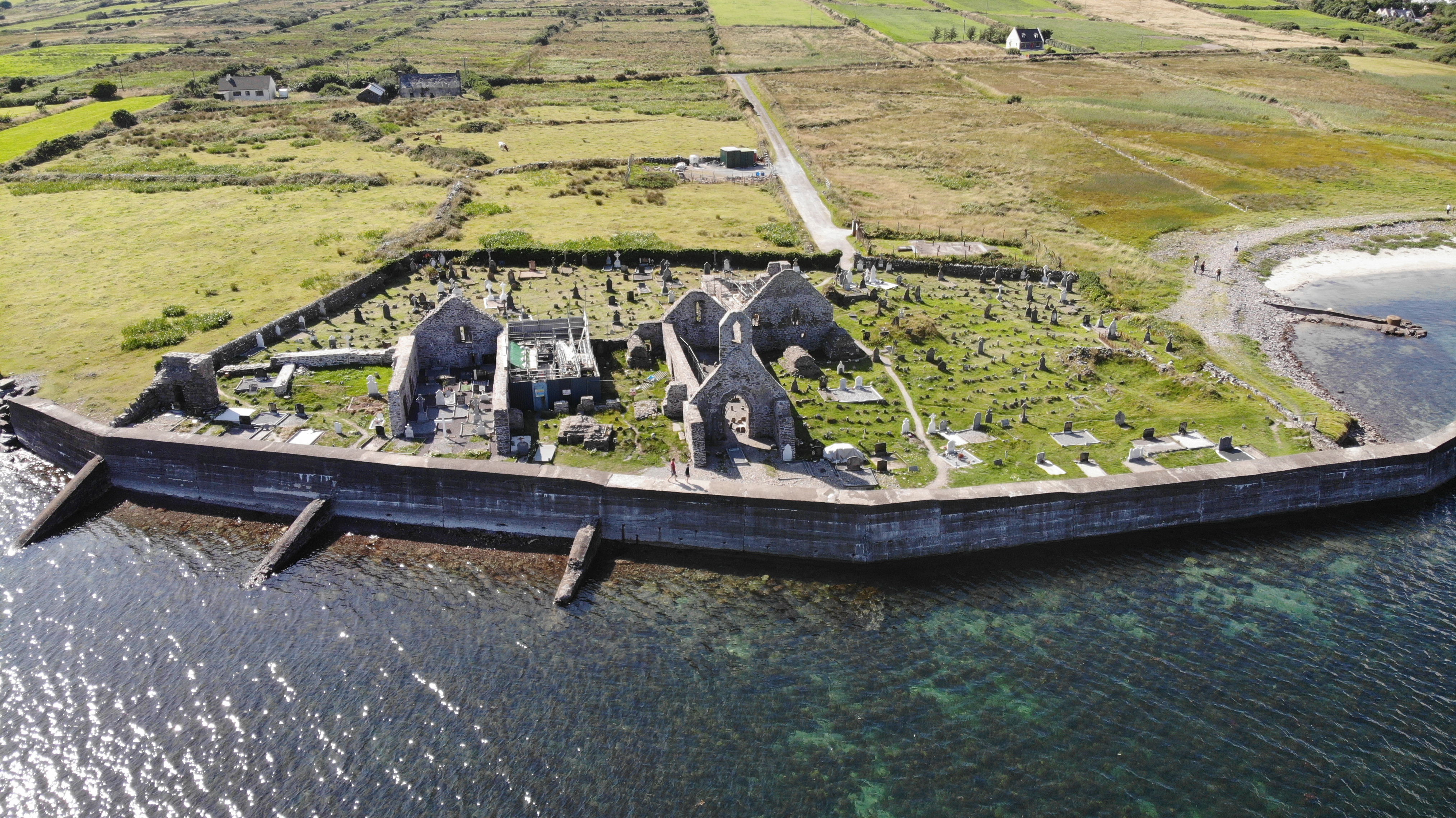
Ballinskelligs Priory was an Arrouaisian house of Augustinian canons.[9]
Within Ballinskelligs are the two parts of the Cill Rialaig project, the Artist Retreat in the former village of Cill Rialaig, and the Arts Centre in the village of Dun Geagan. The project is led since foundation in 1991 by local resident Noelle Campbell-Sharp of Canuig House.[citation needed]
See also
- List of abbeys and priories in Ireland (County Kerry)
- List of towns and villages in Ireland
References
- "Table 10: Population in each county, city, rural area and electoral division within the Gaeltacht, 2006 and 2011" (PDF). Census 2011. Central Statistics Office. p. 130.
- Placenames Database of Ireland
- Deidre Flanagan et al.: Irish Place Names, Gill & Macmillan, 1994, ISBN 0-7171-2066-X, p. 172
- "Ballinskelligs - Where is Ballinskelligs?". Visit Ballinskelligs. Retrieved 23 August 2019.
...what often confuses first time visitors is that Ballinskelligs isn’t a town or a village, it’s an area made up of small villages...
- "ArcGIS Web Application". census.cso.ie. Retrieved 15 November 2020.
- Lord Killanin and Michael V. Duignan: The Shell Guide to Ireland, Ebury Press, London 1967, p. 86
- Ballinskelligs Castle Committee. "Ballinskelligs Castle". Archived from the original on 11 February 2013. Retrieved 20 August 2012.
- Sheehan, John (1988). "Ballinskelligs Castle, Ballinskelligs". Department of the Environment, Heritage and Local Government. Retrieved 21 August 2012.
- Saints and Stones. "Ballinskelligs Priory". Retrieved 21 August 2012.
| Wikimedia Commons has media related to Ballinskelligs. |
Places in County Kerry | ||
|---|---|---|
County town: Tralee | ||
| Towns |
|  |
| Parishes, Villages and Townlands |
| |
| Islands |
| |
| ||
На других языках
- [en] Ballinskelligs
[ru] Баллинскеллигс
Баллинскеллигс[1] (англ. Ballinskelligs; ирл. Baile na Sceilge)[2] — деревня в Ирландии, находится в графстве Керри (провинция Манстер). Является частью Гэлтахта.Другой контент может иметь иную лицензию. Перед использованием материалов сайта WikiSort.org внимательно изучите правила лицензирования конкретных элементов наполнения сайта.
WikiSort.org - проект по пересортировке и дополнению контента Википедии