world.wikisort.org - Indonesia
Pringsewu Regency is a regency of Lampung Province, Sumatra, Indonesia. It has an area of 625 km² and had a population of 364,825 people at the 2010 Census[2] and 405,466 at the 2020 Census;[3] the official estimate as at mid 2021 was 406,823.[4] The regency seat is the town of Pringsewu, located 37 kilometres from the provincial capital of Bandar Lampung. The regency was created on 29 October 2008 from the former eastern part of Tanggamus Regency.[5]
Pringsewu Regency
(Kabupaten Pringsewu) | |
|---|---|
Regency | |
 A paddy field in Gadingrejo, Pringsewu | |
 Coat of arms | |
| Motto(s): Jejama Secancanan (Together on mutual cooperation) | |
 Location within Lampung | |
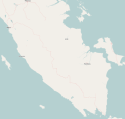 Pringsewu Regency Location in Southern Sumatra, Sumatra and Indonesia  Pringsewu Regency Pringsewu Regency (Sumatra)  Pringsewu Regency Pringsewu Regency (Indonesia) | |
| Coordinates: 5.4221°S 104.9345°E | |
| Country | Indonesia |
| Province | Lampung |
| Regency seat | Pringsewu |
| Government | |
| • Regent | Sujadi |
| • Vice Regent | Fauzi |
| Area | |
| • Total | 625.00 km2 (241.31 sq mi) |
| Population (mid 2021 estimate)[1] | |
| • Total | 406,823 |
| • Density | 650/km2 (1,700/sq mi) |
| Time zone | UTC+7 (IWST) |
| Area code | (+62) 729 |
| Website | pringsewukab |
The regency name came from Javanese language terms "Thousand (sewu) bamboo (pring)", as the location of the town was once a bamboo forest.[6]
Administrative districts
Administratively at 2010 the regency was divided into eight districts (kecamatan). However, since 2010 a ninth district (Pangelaran Utara) has been created from part of the existing Pangelaran District, bringing the total to nine districts. Each district has the same name as the district's administrative centre. These are tabulated below with their areas and their populations at the 2010 Census[7] and the 2020 Census,[8] together with the official estimates as at mid 2021.[9] The table also includes the number of administrative villages (rural desa and urban kelurahan) in each district and its post code.
| Name | Area in km2 | Pop'n Census 2010 | Pop'n Census 2020 | Pop'n Estimate mid 2021 | No. of villages | Post code |
|---|---|---|---|---|---|---|
| Pardasuka | 94.64 | 32,131 | 35,174 | 35,292 | 13 | 35381 |
| Ambarawa | 30.99 | 32,283 | 36,387 | 36,509 | 8 | 35376 |
| Pangelaran | 72.47 | 58,945 | 52,042 | 52,216 | 22 | 35375 |
| Pangelaran Utara (North Pangelaran) | 100.28 | (a) | 15,301 | 15,352 | 10 | 35370 |
| Pringsewu (district) | 53.29 | 76,082 | 81,776 | 82,050 | 15 | 35371 |
| Gadingrejo | 85.71 | 69,307 | 77,727 | 77,987 | 23 | 35372 |
| Sukoharjo | 72.95 | 44,696 | 49,704 | 49,870 | 16 | 35673 |
| Banyumas | 39.85 | 18,996 | 21,292 | 21,363 | 11 | 35373 |
| Adi Luwih | 74.82 | 32,929 | 36,063 | 36,184 | 13 | 35674 |
| Totals | 625.00 | 364,825 | 405,466 | 406,823 | 131 |
Note: (a) the 2010 population for the new Pangelaran Utara District is included with the figure for Pangelaran District, from which it was separated.
References
- Badan Pusat Statistik, Jakarta, 2022.
- Biro Pusat Statistik, Jakarta, 2011.
- Badan Pusat Statistik, Jakarta, 2021.
- Badan Pusat Statistik, Jakarta, 2022.
- "Regency Pringsewu". Visit to Lampung. Retrieved 22 February 2011.
- Benoit, D.; Marc Pain (1989). Transmigration et migrations spontanées en Indonésie: Transmigration and spontaneous migrations in Indonesia. IRD Editions. ISBN 9782709909709.
- Biro Pusat Statistik, Jakarta, 2011.
- Badan Pusat Statistik, Jakarta, 2021.
- Badan Pusat Statistik, Jakarta, 2022.
Regencies and cities of Lampung | ||
|---|---|---|
Capital: Bandar Lampung | ||
| Regencies | ||
| Cities | ||
На других языках
[de] Pringsewu (Regierungsbezirk)
Pringsewu ist ein indonesischer Regierungsbezirk (Kabupaten) in der indonesischen Provinz Lampung auf der Insel Sumatra. Stand 2020 leben hier circa 400.000 Menschen.[1] Der Regierungssitz des Kabupaten Pringsewu ist der gleichnamige Ort Pringsewu.- [en] Pringsewu Regency
Другой контент может иметь иную лицензию. Перед использованием материалов сайта WikiSort.org внимательно изучите правила лицензирования конкретных элементов наполнения сайта.
WikiSort.org - проект по пересортировке и дополнению контента Википедии