world.wikisort.org - India
Mandsaur is a city and a municipality in Mandsaur district located on Border of Mewar and Malwa region of Madhya Pradesh state of central India. It is the administrative headquarters of Mandsaur District. The ancient Pashupatinath Temple is located in Mandsaur.
This article needs additional citations for verification. (August 2022) |
Mandsaur | |
|---|---|
City(Town) | |
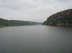
 Gandhi sagar dam | |
| Nickname: dashpur | |
 Mandsaur  Mandsaur | |
| Coordinates: 24.072°N 75.069°E | |
| Country | India |
| State | Madhya Pradesh |
| District | Mandsaur district |
| Government | |
| • Type | BJP |
| • Body | Municipal Council Mandsaur |
| • Mayor | Shri Gotam singh(IAS) |
| Area | |
| • Total | 50 km2 (20 sq mi) |
| Population (2011)[1] | |
| • Total | 141,667 |
| • Density | 2,800/km2 (7,300/sq mi) |
| Demonym(s) | Mandsauri, Mandsaurian |
| Demographics | |
| • Official language | Hindi |
| • Literacy rate | 71.64% |
| Time zone | UTC+5:30 (IST) |
| PIN | 458001/2 |
| Telephone code | 07422 |
| Vehicle registration | MP-14 |
| Website | www |
History
Aulikaras of Dashapura
Epigraphical discoveries have brought to light two ancient royal houses, who call themselves as Aulikaras and ruled from Dashapura (present-day Mandsaur). The first dynasty, who ruled from Dashapura from the beginning comprised the following kings in the order of succession: Jayavarma, Simhavarma, Naravarma, Vishvavarma and Bandhuvarma. The Risthal stone slab inscription discovered in 1983 has brought to light another Aulikara dynasty, which comprised the following kings in the order of succession: Drumavardhana, Jayavardhana Ajitavardhana, Vibhishanavardhana, Rajyavardhana and Prakashadharma. After Parakshadharma, the ruler of Mandsaur was Yashodharma, who is identified with Vishnuvardhana, who erected a pillar of victory at Bayana due to which Bayana's name became Vijaygarh. In all probabilities, he was the son and immediate successor of Prakashadharma.[2]
Yashodharman rule


Sondani (सोंधनी) is a small village at a distance of about 4 km from Mandsaur situated on Mahu-Nimach Highway towards Mahu. In a part of the inscription Yasodharman praises himself for having defeated king Mihirakula:[3]
"He (Yasodharman) to whose two feet respect was paid, with complimentary presents of the flowers from the lock of hair on the top of (his) head, by even that (famous) king Mihirakula, whose forehead was pained through being bent low down by the strength of (his) arm in (the act of compelling) obeisance"
— Sondani pillar inscription[4]
Gurjara-Pratihara Dynasty
The Gurjara Pratihara empire was extended up to Mandasor during the reign of Mahendrapala II.[5]
Medieval era
There are two gardens in which there is a pillar of torandwar. It is believed to be pillar of Surya Mandir of the inscription of Bandhu Varma. There is a Shiva statue also in the garden.[6]
Princely State
In 19th century before India's independence in 1947, Mandsaur was part of the princely state of Gwalior. It gave its name to the treaty with the Holkar Maharaja of Indore, who concluded the Third Anglo-Maratha War and the Pindari War in 1818. At the turn of the 20th century it was a centre of the Malwa opium trade.
Mention in Kalidas Manuscript
Mention of Dashpur can be found in Kalidas poem Meghdoot (Purva-megha) 47th stanza. Kalidas writes about the beauty of the eyes of women from Dashpur in his aesthetic piece of words.
Geography
Mandsaur District forms the northern projection of Madhya Pradesh from its western Division, i.e., Ujjain Commissioner's Division. It lies between the parallels of latitude 230 45' 50" North and 250 2' 55" North, and between the meridians of longitude 740 42' 30" East and 750 50' 20" East.
The District is an average size district of Madhya Pradesh. It extends for about 142 km (88 mi) from north to south and 124 km (77 mi) from east to west. The total area is 5,521 km2 (2,132 sq mi) with a population of 1,16,483 in 2001.
Demographics
As of 2011[update] India census,[1] Mandsaur had a population of 141,468 male population was 72,370 and female population was 69,098, giving a sex-ration of 898. Mandsaur had an effective literacy rate of 86.79%, higher than the national average: male literacy was 92.74, and female literacy was 80.60%. 15,721 (11.1%) of the population was under 6 years of age.
See also
- Mandsaur Institute of Technology
References
- "Cities having population 1 lakh and above, Census 2011" (PDF). censusindia.gov. Retrieved 20 November 2020.
- Agarwal, Ashvini (1989). Rise and Fall of the Imperial Guptas, Delhi:Motilal Banarsidass, ISBN 81-208-0592-5, pp.250-6
- Coin Cabinet of the Kunsthistorisches Museum Vienna
- Punjab Monitor, April 2013 , from Fleet, John F. Corpus Inscriptionum Indicarum: Inscriptions of the Early Guptas. Vol. III. Calcutta: Government of India, Central Publications Branch, 1888, 147-148.
- Rama Shankar Tripathi (1989). History of Kanauj: To the Moslem Conquest. Motilal Banarsidass. p. 269. ISBN 978-81-208-0404-3.
- Usha Agarwal:Mandsaur Zile ke Puratatvik samarakon ki paryatan ki drishti se sansadhaniyata - Ek Adhyayan, Chrag Prakashan Udaipur, 2007, p. 19
- This article incorporates text from a publication now in the public domain: Chisholm, Hugh, ed. (1911). "Mandasor". Encyclopædia Britannica. Vol. 17 (11th ed.). Cambridge University Press. p. 559.
На других языках
[de] Mandsaur
Mandsaur oder Mandasor (Hindi: .mw-parser-output .Deva{font-size:120%}@media all and (min-width:800px){.mw-parser-output .Deva{font-size:calc(120% - ((100vw - 800px)/80))}}@media all and (min-width:1000px){.mw-parser-output .Deva{font-size:100%}}मंदसौर) ist eine Großstadt im äußersten Westen des indischen Bundesstaats Madhya Pradesh. Sie war einst eine wichtige Stadt im Grenzgebiet zwischen den Fürstentümern bzw. Sultanaten von Malwa und Mewar und ist heute die Hauptstadt eines Grenzdistrikts zu Rajasthan.- [en] Mandsaur
Другой контент может иметь иную лицензию. Перед использованием материалов сайта WikiSort.org внимательно изучите правила лицензирования конкретных элементов наполнения сайта.
WikiSort.org - проект по пересортировке и дополнению контента Википедии