world.wikisort.org - India
Hardaspur is a village in Amawan block of Rae Bareli district, Uttar Pradesh, India.[2] As of 2011, its population is 2,974, in 570 households.[2] It has 3 primary schools and one small clinic.[2]
Hardaspur
Hardāspur | |
|---|---|
Village | |
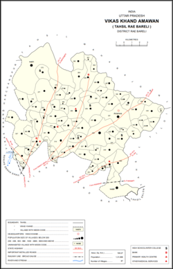 Map showing Hardaspur (#305) in Amawan CD block | |
 Hardaspur Location in Uttar Pradesh, India | |
| Coordinates: 26.278634°N 81.2499°E[1] | |
| Country India | |
| State | Uttar Pradesh |
| District | Raebareli |
| Area | |
| • Total | 2.394 km2 (0.924 sq mi) |
| Population (2011)[2] | |
| • Total | 2,974 |
| • Density | 1,200/km2 (3,200/sq mi) |
| Languages | |
| • Official | Hindi |
| Time zone | UTC+5:30 (IST) |
| Vehicle registration | UP-35 |
Hardaspur was historically the seat of a small taluqdari estate held by a Kayasth family who had a close association with the Bais rajas of Daundia Khera.[3] They claimed descent from one Ram Lal, who was supposedly the Diwan to the first Bais ruler, Abhai Chand, and several of his descendants held the same office for later Bais rajas.[3] One of them, Nabh Chand, is said to have been adopted by the Bais raja Tilok Chand, and so his descendants were styled Thakur.[3] One of them, Har Das, founded the village of Hardaspur around the time of Akbar; his brother Rath Rai was made qanunqo of the pargana of Rae Bareli.[3]
The Kayasth taluqdars of Hardaspur never gained a large territory because they were surrounded by powerful Rajput taluqdars and often in conflict with their Muslim neighbours.[3] In the 1800s, the taluqdar Baij Nath obtained the sanad for the Hardaspur estate, which comprised nine villages at the time.[3] At the turn of the 20th century, the Hardaspur estate was held by Thakurain Jugraj Kunwar, the widow of Baij Nath's grandson; by then it only consisted of two villages in the pargana of Rae Bareli.[3]
The 1961 census recorded Hardaspur as comprising 3 hamlets, with a total population of 1,141 people (579 male and 562 female), in 250 households and 231 physical houses.[4] The area of the village was given as 582 acres.[4]
The 1981 census recorded Hardaspur as having a population of 1,692 people, in 304 households, and having an area of 239.58 hectares.[5] The main staple foods were given as wheat and rice.[5]
References
- "Geonames Search". Do a radial search using these coordinates here.
- "Census of India 2011: Uttar Pradesh District Census Handbook - Rae Bareli, Part A (Village and Town Directory)" (PDF). Census 2011 India. pp. 185–201. Retrieved 5 August 2021.
- Nevill, H.R. (1905). Rai Bareli: A Gazetteer, Being Volume XXXIX Of The District Gazetteers Of The United Provinces Of Agra And Oudh. Allahabad: Government Press. pp. 94–5. Retrieved 3 December 2021.
- Census 1961: District Census Handbook, Uttar Pradesh (39 - Raebareli District) (PDF). Lucknow. 1965. pp. xxxvi-xxxvii of section "Rae Bareli Tahsil". Retrieved 5 August 2021.
- Census 1981 Uttar Pradesh: District Census Handbook Part XIII-A: Village & Town Directory, District Rae Bareli (PDF). 1982. pp. 80–1. Retrieved 5 August 2021.
This Raebareli district location article is a stub. You can help Wikipedia by expanding it. |
Другой контент может иметь иную лицензию. Перед использованием материалов сайта WikiSort.org внимательно изучите правила лицензирования конкретных элементов наполнения сайта.
WikiSort.org - проект по пересортировке и дополнению контента Википедии