world.wikisort.org - India
Dalhousie (Hindi: ḍalhauzī, pronounced [ɖəlɦɔːziː]) is a hill station, near town of Chamba in Chamba district in the Indian state of Himachal Pradesh. It is situated on five hills and has an elevation of 1,970 m (6,460 ft) above sea level.[1]
Dalhousie
ḍalhauzī | |
|---|---|
Hill Station | |
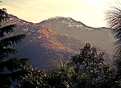
 Hill Station of Dalhousie in Chamba district, Himachal Pradesh, India | |
 Dalhousie  Dalhousie | |
| Coordinates: 32.53°N 75.98°E | |
| Country | |
| State | |
| District | Chamba |
| Named for | Lord Dalhousie |
| Elevation | 1,970 m (6,460 ft) |
| Population (2011) | |
| • Total | 7,051 |
| • Rank | 25 in HP |
| Time zone | UTC+5:30 (IST) |
| PIN | 176304 |
| Telephone code | +91 1899 |
| Vehicle registration | HP-47 |
Etymology
Dalhousie Town was named after The Earl of Dalhousie, who was the British Governor-General in India while establishing this place as a summer retreat.[2]
Climate
Dalhousie has a humid subtropical climate. Late summer and early spring see torrential rainfall due to monsoonal influence. The city sees over 90 frost days per year and 20-30 snowy days. The average night temperature during the season is around 4 °C (39 °F), while the maximum is close to 11 °C (52 °F).
| Climate data for Dalhousie, India (1961–1990, rainfall 1951–2000) | |||||||||||||
|---|---|---|---|---|---|---|---|---|---|---|---|---|---|
| Month | Jan | Feb | Mar | Apr | May | Jun | Jul | Aug | Sep | Oct | Nov | Dec | Year |
| Record high °C (°F) | 21.7 (71.1) |
29.4 (84.9) |
30.7 (87.3) |
32.6 (90.7) |
34.4 (93.9) |
35.5 (95.9) |
32.8 (91.0) |
28.4 (83.1) |
28.0 (82.4) |
27.9 (82.2) |
25.7 (78.3) |
23.9 (75.0) |
35.5 (95.9) |
| Average high °C (°F) | 11.5 (52.7) |
12.7 (54.9) |
17.3 (63.1) |
21.3 (70.3) |
24.9 (76.8) |
26.6 (79.9) |
23.6 (74.5) |
22.7 (72.9) |
22.8 (73.0) |
22.0 (71.6) |
17.8 (64.0) |
14.4 (57.9) |
19.8 (67.6) |
| Average low °C (°F) | 2.3 (36.1) |
2.7 (36.9) |
6.3 (43.3) |
10.5 (50.9) |
13.8 (56.8) |
16.2 (61.2) |
15.7 (60.3) |
15.5 (59.9) |
13.9 (57.0) |
10.9 (51.6) |
6.9 (44.4) |
4.4 (39.9) |
9.9 (49.8) |
| Record low °C (°F) | −8.6 (16.5) |
−8.0 (17.6) |
−1.2 (29.8) |
0.6 (33.1) |
2.0 (35.6) |
8.0 (46.4) |
8.3 (46.9) |
11.1 (52.0) |
8.0 (46.4) |
−2.2 (28.0) |
0.1 (32.2) |
−8.0 (17.6) |
−8.6 (16.5) |
| Average rainfall mm (inches) | 155.1 (6.11) |
122.2 (4.81) |
155.7 (6.13) |
96.2 (3.79) |
62.5 (2.46) |
130.8 (5.15) |
588.0 (23.15) |
573.2 (22.57) |
245.7 (9.67) |
73.0 (2.87) |
37.7 (1.48) |
70.9 (2.79) |
2,311 (90.98) |
| Average rainy days (≥ 2.5 mm) | 6.5 | 5.9 | 6.5 | 5.3 | 4.2 | 6.4 | 18.3 | 19.8 | 8.8 | 2.7 | 1.8 | 3.4 | 89.6 |
| Average relative humidity (%) (at 17:30 IST) | 72 | 67 | 64 | 57 | 50 | 54 | 78 | 85 | 79 | 70 | 70 | 68 | 68 |
| Source: India Meteorological Department[3] | |||||||||||||
See also
References
- Gopal, Madan (1990). K.S. Gautam (ed.). India through the ages. Publication Division, Ministry of Information and Broadcasting, Government of India. p. 177.
- "Dalhousie: perfect summer getaway". Bangalore Mirror. 4 March 2010. Archived from the original on 6 March 2010. Retrieved 1 May 2013.
- "Climate of Himachal Pradesh" (PDF). Climatological Summaries of States Series - No. 15. India Meteorological Department. January 2010. pp. 36–42. Archived from the original (PDF) on 20 February 2020. Retrieved 8 March 2020.
- "Snowfall throws shooting schedule of Lootera out of gear".
External links
Wikimedia Commons has media related to Dalhousie, India.
 Dalhousie, India travel guide from Wikivoyage
- More information about Dalhousie.
На других языках
[de] Dalhousie (Indien)
Dalhousie (Hindi .mw-parser-output .Deva{font-size:120%}@media all and (min-width:800px){.mw-parser-output .Deva{font-size:calc(120% - ((100vw - 800px)/80))}}@media all and (min-width:1000px){.mw-parser-output .Deva{font-size:100%}}डलहौज़ी) ist eine etwa 7500 Einwohner zählende Kleinstadt im Chamba-Distrikt im nordindischen Bundesstaat Himachal Pradesh.- [en] Dalhousie, India
Текст в блоке "Читать" взят с сайта "Википедия" и доступен по лицензии Creative Commons Attribution-ShareAlike; в отдельных случаях могут действовать дополнительные условия.
Другой контент может иметь иную лицензию. Перед использованием материалов сайта WikiSort.org внимательно изучите правила лицензирования конкретных элементов наполнения сайта.
Другой контент может иметь иную лицензию. Перед использованием материалов сайта WikiSort.org внимательно изучите правила лицензирования конкретных элементов наполнения сайта.
2019-2025
WikiSort.org - проект по пересортировке и дополнению контента Википедии
WikiSort.org - проект по пересортировке и дополнению контента Википедии