world.wikisort.org - Germany
Söhrewald is a municipality in the district of Kassel, in Hesse, Germany. It is located 13 kilometers southeast of Kassel. The municipality was formed by the former independent municipalities Eiterhagen, Wattenbach and Wellerode in 1970.
Söhrewald | |
|---|---|
Municipality | |
 Coat of arms | |
Location of Söhrewald within Kassel district 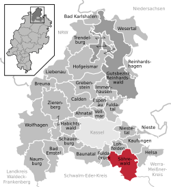 | |
 Söhrewald  Söhrewald | |
| Coordinates: 51°13′N 09°37′E | |
| Country | Germany |
| State | Hesse |
| Admin. region | Kassel |
| District | Kassel |
| Government | |
| • Mayor (2016–22) | Michael Steisel[1] |
| Area | |
| • Total | 58.9 km2 (22.7 sq mi) |
| Elevation | 350 m (1,150 ft) |
| Population (2020-12-31)[2] | |
| • Total | 4,636 |
| • Density | 79/km2 (200/sq mi) |
| Time zone | UTC+01:00 (CET) |
| • Summer (DST) | UTC+02:00 (CEST) |
| Postal codes | 34320 |
| Dialling codes | 05608 |
| Vehicle registration | KS |
| Website | www.soehrewald.de |
Geography
Söhrewald borders in the north to the municipality Lohfelden, in the northeast to the municipality Kaufungen and Helsa all three in the district of Kassel), in the east to the city of Hessisch Lichtenau (Werra-Meißner-Kreis), in the south with the city of Melsungen, in the southeast to the municipality Körle and in the west to the municipality Guxhagen (all the three in the district of Schwalm-Eder)
References
- Direkt gewählte (Ober-) Bürgermeister/-innen der hessischen Städte und Gemeinden, accessed 7 July 2021.
- "Bevölkerung in Hessen am 31.12.2020 nach Gemeinden". Hessisches Statistisches Landesamt (in German). June 2021.
Towns and municipalities in Kassel district | ||
|---|---|---|
 | ||
Authority control | |
|---|---|
| General |
|
| National libraries | |
This Hesse location article is a stub. You can help Wikipedia by expanding it. |
На других языках
- [en] Söhrewald
[ru] Зёревальд (посёлок)
Зёревальд (нем. Söhrewald) — коммуна в Германии, в земле Гессен. Подчиняется административному округу Кассель. Входит в состав района Кассель. Население составляет 4987 человек (на 31 декабря 2010 года).[1] Занимает площадь 58,9 км². Официальный код — 06 6 33 024.Текст в блоке "Читать" взят с сайта "Википедия" и доступен по лицензии Creative Commons Attribution-ShareAlike; в отдельных случаях могут действовать дополнительные условия.
Другой контент может иметь иную лицензию. Перед использованием материалов сайта WikiSort.org внимательно изучите правила лицензирования конкретных элементов наполнения сайта.
Другой контент может иметь иную лицензию. Перед использованием материалов сайта WikiSort.org внимательно изучите правила лицензирования конкретных элементов наполнения сайта.
2019-2026
WikiSort.org - проект по пересортировке и дополнению контента Википедии
WikiSort.org - проект по пересортировке и дополнению контента Википедии