world.wikisort.org - Germany
Grebenstein (German pronunciation: [ˈɡʁeːbm̩ˌʃtaɪ̯n] (![]() listen)) is a town in the district of Kassel, in Hesse, Germany. It is located 16 km northwest of Kassel on the German Timber-Frame Road. In 1762 it was the scene of a skirmish between British and French troops during the Seven Years' War.
listen)) is a town in the district of Kassel, in Hesse, Germany. It is located 16 km northwest of Kassel on the German Timber-Frame Road. In 1762 it was the scene of a skirmish between British and French troops during the Seven Years' War.
Grebenstein | |
|---|---|
Town | |
|
Coat of arms | |
Location of Grebenstein within Kassel district  | |
 Grebenstein  Grebenstein | |
| Coordinates: 51°27′N 09°25′E | |
| Country | Germany |
| State | Hesse |
| Admin. region | Kassel |
| District | Kassel |
| Government | |
| • Mayor (2016–22) | Danny Sutor[1] |
| Area | |
| • Total | 49.85 km2 (19.25 sq mi) |
| Elevation | 249 m (817 ft) |
| Population (2020-12-31)[2] | |
| • Total | 5,720 |
| • Density | 110/km2 (300/sq mi) |
| Time zone | UTC+01:00 (CET) |
| • Summer (DST) | UTC+02:00 (CEST) |
| Postal codes | 34393 |
| Dialling codes | 05674 |
| Vehicle registration | KS or HOG |
| Website | www |
Gallery
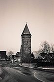 One of the historic towers on the town wall
 Parish church, 2005


References
- Direkt gewählte (Ober-) Bürgermeister/-innen der hessischen Städte und Gemeinden, accessed 5 July 2021.
- "Bevölkerung in Hessen am 31.12.2020 nach Gemeinden". Hessisches Statistisches Landesamt (in German). June 2021.
External links
- City's Homepage (in German)
Wikimedia Commons has media related to Grebenstein, Germany.
Towns and municipalities in Kassel district | ||
|---|---|---|
 | ||
Authority control | |
|---|---|
| General | |
| National libraries | |
| Other |
|
This Hesse location article is a stub. You can help Wikipedia by expanding it. |
На других языках
- [en] Grebenstein
[ru] Гребенштайн
Гребенштайн (нем. Grebenstein) — город в Германии, в земле Гессен. Подчинён административному округу Кассель. Входит в состав района Кассель. Население составляет 5936 человек (на 31 декабря 2010 года).[1] Занимает площадь 49,85 км². Официальный код — 06 6 33 010.Текст в блоке "Читать" взят с сайта "Википедия" и доступен по лицензии Creative Commons Attribution-ShareAlike; в отдельных случаях могут действовать дополнительные условия.
Другой контент может иметь иную лицензию. Перед использованием материалов сайта WikiSort.org внимательно изучите правила лицензирования конкретных элементов наполнения сайта.
Другой контент может иметь иную лицензию. Перед использованием материалов сайта WikiSort.org внимательно изучите правила лицензирования конкретных элементов наполнения сайта.
2019-2026
WikiSort.org - проект по пересортировке и дополнению контента Википедии
WikiSort.org - проект по пересортировке и дополнению контента Википедии