world.wikisort.org - Germany
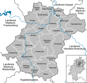
Schwalm-Eder-Kreis is a Kreis (district) in the north of Hesse, Germany. Neighbouring districts are Kassel, Werra-Meißner, Hersfeld-Rotenburg, Vogelsberg, Marburg-Biedenkopf, and Waldeck-Frankenberg.
Schwalm-Eder-Kreis | |
|---|---|
District | |
 Flag  Coat of arms | |
 | |
| Country | Germany |
| State | Hesse |
| Adm. region | Kassel |
| Capital | Homberg (Efze) |
| Area | |
| • Total | 1,538.56 km2 (594.04 sq mi) |
| Population (31 December 2020)[1] | |
| • Total | 179,840 |
| • Density | 120/km2 (300/sq mi) |
| Time zone | UTC+01:00 (CET) |
| • Summer (DST) | UTC+02:00 (CEST) |
| Vehicle registration | HR, FZ, MEG, ZIG |
| Website | http://www.schwalm-eder-kreis.de |
History
In 1821 districts were created in Hesse. They included the districts of Fritzlar, Homberg, Melsungen, and Ziegenhain. In 1932 the districts of Fritzlar and Homberg were merged; in 1974 the three districts of Fritzlar-Homberg, Melsungen, and Ziegenhain were merged into the Schwalm-Eder district.
The district is twinned with the Finnish city of Kajaani, the British district of Sedgemoor, and the Polish district of Piła.
Geography
The Schwalm and Eder rivers give the district its name. After they merge close to Felsberg, the Eder enters the Fulda to the north at Edermunde. The southeast of the district includes a portion of the Knüllgebirge range of low mountains; the highest elevation is 634 metres (2,080 ft). In the north are the hills of the Homberger Hochland. The centre of the district is largely rural, and is surrounded by the mountains of the Knüll, the Stölzinger Gebirge, and the Kellerwald with the 675 metre-high Wüstegarten mountain, the highest peak in the district.
Geology
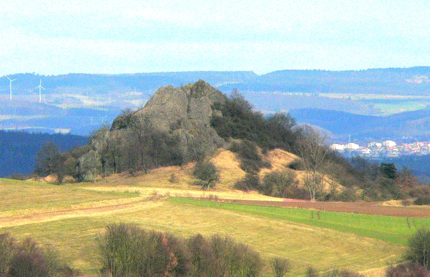
In the east, the geology of the Knüllgebirge is dominated by the clastic Triassic strata of the Middle Buntsandstein, as is the western region around the Gilserberg.[2]
Soils of weathered Buntsandstein are generally acidic to slightly basic and nutrient-poor. For the most part the land is forested.
In the district of Fritzlar there are outcrops of younger Upper Buntsandstein, known as the Röt Formation, because of its red colour. These strata consist of clay beds and various kinds of calcareous beds, interbedded with clayey marls.
Coat of arms
The coat of arms shows the lion of Hesse (azure a lion rampant crowned, barry of six argent and gules, armed or). Below are wavy lines (three bars wavy argent) that symbolise the three main rivers in the district, the Schwalm, the Eder, and the Fulda.
Towns and municipalities
| Towns | Municipalities | |
|---|---|---|
See also
- Schwalm (region)
References
- "Bevölkerung in Hessen am 31.12.2020 nach Gemeinden". Hessisches Statistisches Landesamt (in German). June 2021.
- "Geologie - Landesgeschichtliches Informationssystem Hessen". Retrieved 28 October 2014.
External links
![]() Media related to Schwalm-Eder-Kreis at Wikimedia Commons
Media related to Schwalm-Eder-Kreis at Wikimedia Commons
- Official website (German)
| Urban districts | |
|---|---|
| Rural districts |
|
Districts of German states (Full list)
| |
На других языках
[de] Schwalm-Eder-Kreis
Der Schwalm-Eder-Kreis ist ein Landkreis im Regierungsbezirk Kassel in Nordhessen. Die Kreisstadt ist Homberg (Efze). Flächenmäßig ist er der zweitgrößte Landkreis Hessens nach dem Landkreis Waldeck-Frankenberg. Er wurde 1974 im Rahmen der Gebietsreform in Hessen aus den Altkreisen Fritzlar-Homberg, Melsungen und Ziegenhain (letzterer außer der damaligen Gemeinde Mengsberg) sowie der Stadt Züschen aus dem ehemaligen Landkreis Waldeck gebildet.- [en] Schwalm-Eder-Kreis
[es] Schwalm-Eder-Kreis
El distrito Schwalm-Eder es un Landkreis (distrito rural) en la Región de Kassel en el norte del estado de Hesse (Alemania). Los municipios vecinos por el norte son el distrito de Kassel, al noroeste el distrito Werra-Meißer, al este el distrito de Hersfeld-Rotemburgo, al sur es fronterizo con el distrito de Vogelsberg, al sudeste el distrito Marburgo-Biedenkopf y al oeste el distrito de Waldeck-Frankenberg. La capital del distrito recae sobre la ciudad de Homberg.[ru] Швальм-Эдер (район)
Швальм-Эдер (нем. Schwalm-Eder-Kreis) — район в Германии. Центр района — город Хомберг. Район входит в землю Гессен. Подчинён административному округу Кассель. Занимает площадь 1538 км². Население — 183,3 тыс. чел. (2010). Плотность населения — 119 человек/км². Официальный код района — 06 6 34.Другой контент может иметь иную лицензию. Перед использованием материалов сайта WikiSort.org внимательно изучите правила лицензирования конкретных элементов наполнения сайта.
WikiSort.org - проект по пересортировке и дополнению контента Википедии