world.wikisort.org - Germany
The Fulda District (German: Landkreis Fulda; German pronunciation: [ˈfʊlda]) is a Kreis (district) in the north-east of Hesse, Germany. Neighboring districts are Hersfeld-Rotenburg, Wartburgkreis, Schmalkalden-Meiningen, Rhön-Grabfeld, Bad Kissingen, Main-Kinzig, Vogelsbergkreis.
This article may be expanded with text translated from the corresponding article in German. (April 2021) Click [show] for important translation instructions.
|
Fulda Landkreis Fulda | |
|---|---|
District | |
 Flag  Coat of arms | |
 | |
| Country | Germany |
| State | Hesse |
| Adm. region | Kassel |
| Capital | Fulda |
| Area | |
| • Total | 1,380.39 km2 (532.97 sq mi) |
| Population (31 December 2020)[1] | |
| • Total | 223,023 |
| • Density | 160/km2 (420/sq mi) |
| Time zone | UTC+01:00 (CET) |
| • Summer (DST) | UTC+02:00 (CEST) |
| Vehicle registration | FD |
| Website | http://www.landkreis-fulda.de |
History
The district was created in 1821, when the duchy of Fulda became a province of Hesse, and was split into four districts. In 1866 the north of Hesse became a part of Prussia, including the Gersfeld area which previously belonged to Bavaria. In 1927 the city of Fulda left the district to become a district-free city, and in 1932 the remaining district was merged with the district of Gersfeld. In 1972, the previously small municipalities were merged into 23 bigger ones, and in 1974 the city of Fulda lost its status as district-free city and joined the district again. In 1972 the major part of the Hünfeld district was added to the district.
Geography

The district is located in the Rhön and Vogelsberg mountains. The main river of the district is the Fulda.
Coat of arms
The left side of the coat of arms shows a black cross, the sign of the monastery of Fulda. The lion on the right side is taken from the Hesse coat of arms, symbolizing that the district was part of Hesse 1821–1866, and again after 1945. The coat of arms was granted in 1936.
Towns and municipalities
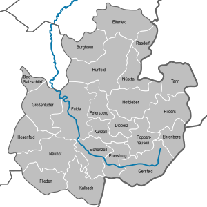
| Towns | Municipalities | |
|---|---|---|
References
- "Bevölkerung in Hessen am 31.12.2020 nach Gemeinden". Hessisches Statistisches Landesamt (in German). June 2021.
External links
- Official website (German)
- allround Informationportal of Fulda
- 360 degree virtual tour through the hessian rhoen
| Urban districts | |
|---|---|
| Rural districts |
|
Districts of German states (Full list)
| |
Authority control | |
|---|---|
| General | |
| National libraries | |
На других языках
[de] Landkreis Fulda
Der Landkreis Fulda liegt im Regierungsbezirk Kassel in Osthessen am östlichen Rand der Metropolregion Rhein-Main.- [en] Fulda (district)
[es] Distrito de Fulda
El Distrito de Fulda (en alemán: Landkreis Fulda) es un distrito rural (Landkreis) en la región administrativa de Kassel (Regierungsbezirk Kassel) del estado de Hesse (Hessen), en la República Federal de Alemania.[ru] Фульда (район)
Фульда (нем. Fulda) — район в Германии. Центр района — город Фульда. Район входит в землю Гессен. Подчинён административному округу Кассель. Занимает площадь 1380 км². Население — 217,4 тыс. чел. (2010). Плотность населения — 157 человек/км². Официальный код района — 06 6 31.Другой контент может иметь иную лицензию. Перед использованием материалов сайта WikiSort.org внимательно изучите правила лицензирования конкретных элементов наполнения сайта.
WikiSort.org - проект по пересортировке и дополнению контента Википедии