world.wikisort.org - Germany
Dahlem is a municipality in the district of Euskirchen. It has the lowest population density and population of all municipalities of in the state of North Rhine-Westphalia, Germany. It is located in the Eifel hills, approx. 35 km south-west of Euskirchen. The small medieval town Kronenburg is part of the municipality.
Dahlem | |
|---|---|
Municipality | |
 | |
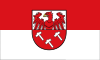 Flag  Coat of arms | |
Location of Dahlem within Euskirchen district 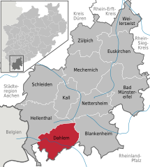 | |
 Dahlem  Dahlem | |
| Coordinates: 50°22′59″N 06°32′59″E | |
| Country | Germany |
| State | North Rhine-Westphalia |
| Admin. region | Köln |
| District | Euskirchen |
| Government | |
| • Mayor (2020–25) | Jan Lembach[1] (CDU) |
| Area | |
| • Total | 95.18 km2 (36.75 sq mi) |
| Elevation | 539 m (1,768 ft) |
| Population (2020-12-31)[2] | |
| • Total | 4,301 |
| • Density | 45/km2 (120/sq mi) |
| Time zone | UTC+01:00 (CET) |
| • Summer (DST) | UTC+02:00 (CEST) |
| Postal codes | 53949 |
| Dialling codes | 02447 |
| Vehicle registration | EU |
| Website | www.dahlem.de |
Geography
Dahlem is located in the northern Eifel region in the High Fens – Eifel Nature Park between Blankenheim in the Northeast and Stadtkyll the southwest. The Kyll flows through the region from the Glaadtbach. The Heidenköpfe lie in the Ripsdorfer forest to the east.
References
- Wahlergebnisse in NRW Kommunalwahlen 2020, Land Nordrhein-Westfalen, accessed 19 June 2021.
- "Bevölkerung der Gemeinden Nordrhein-Westfalens am 31. Dezember 2020" (in German). Landesbetrieb Information und Technik NRW. Retrieved 21 June 2021.
External links
![]() Media related to Dahlem (Nordeifel) at Wikimedia Commons
Media related to Dahlem (Nordeifel) at Wikimedia Commons
Towns and municipalities in Euskirchen (district) | ||
|---|---|---|
 | ||
| Authority control: National libraries |
|---|
This Euskirchen district location article is a stub. You can help Wikipedia by expanding it. |
На других языках
[de] Dahlem (Nordeifel)
Dahlem in der Eifel ist eine Gemeinde im Kreis Euskirchen. Sie hat die zweitkleinste Einwohnerzahl[2] und die niedrigste Bevölkerungsdichte aller Gemeinden von Nordrhein-Westfalen.- [en] Dahlem, North Rhine-Westphalia
[ru] Далем (Северный Айфель)
Далем (нем. Dahlem) — коммуна в Германии, в земле Северный Рейн-Вестфалия.Текст в блоке "Читать" взят с сайта "Википедия" и доступен по лицензии Creative Commons Attribution-ShareAlike; в отдельных случаях могут действовать дополнительные условия.
Другой контент может иметь иную лицензию. Перед использованием материалов сайта WikiSort.org внимательно изучите правила лицензирования конкретных элементов наполнения сайта.
Другой контент может иметь иную лицензию. Перед использованием материалов сайта WikiSort.org внимательно изучите правила лицензирования конкретных элементов наполнения сайта.
2019-2025
WikiSort.org - проект по пересортировке и дополнению контента Википедии
WikiSort.org - проект по пересортировке и дополнению контента Википедии