world.wikisort.org - Germany
Bad Sulza is a town in the Weimarer Land district, in Thuringia, Germany. It is situated on the river Ilm, 15 km southwest of Naumburg, and 18 km north of Jena. The former municipality Ködderitzsch was merged into Bad Sulza in January 2019, and Saaleplatte in December 2019.
Bad Sulza | |
|---|---|
Town | |
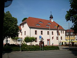
 Town hall | |
 Coat of arms | |
Location of Bad Sulza within Weimarer Land district  | |
 Bad Sulza  Bad Sulza | |
| Coordinates: 51°5′15″N 11°37′20″E | |
| Country | Germany |
| State | Thuringia |
| District | Weimarer Land |
| Government | |
| • Mayor (2018–24) | Dirk Schütze[1] |
| Area | |
| • Total | 91.14 km2 (35.19 sq mi) |
| Elevation | 140 m (460 ft) |
| Population (2020-12-31)[2] | |
| • Total | 7,678 |
| • Density | 84/km2 (220/sq mi) |
| Time zone | UTC+01:00 (CET) |
| • Summer (DST) | UTC+02:00 (CEST) |
| Postal codes | 99518, 99510 (Flurstedt, Gebstedt, Wickerstedt) |
| Dialling codes | 036461 |
| Vehicle registration | AP, APD |
| Website | www.bad-sulza.de |
History
Within the German Empire (1871-1918), Bad Sulza was part of the Grand Duchy of Saxe-Weimar-Eisenach.
Notable citizens
- Johann Agricola (1590-1668), superintendent of the salt plant from 1622 to 1631, used the healing power of Sulza brine for therapeutic purposes.
- Adolf Piltz (1855-1940), German mathematician notable for his work in number theory.
Associated with the city
- Thomas Naogeorgus (actually Kirchmair) (1508-1563), theologian, Neo-Latin poet and playwright
Links
![]() Media related to Bad Sulza at Wikimedia Commons
Media related to Bad Sulza at Wikimedia Commons
References
- Gewählte Bürgermeister - aktuelle Landesübersicht, Freistaat Thüringen, accessed 14 July 2021.
- "Bevölkerung der Gemeinden, erfüllenden Gemeinden und Verwaltungsgemeinschaften in Thüringen Gebietsstand: 31.12.2020". Thüringer Landesamt für Statistik (in German). June 2021.
На других языках
- [en] Bad Sulza
[ru] Бад-Зульца
Бад-Зу́льца (нем. Bad Sulza) — город в Германии, курорт, расположен в земле Тюрингия.Текст в блоке "Читать" взят с сайта "Википедия" и доступен по лицензии Creative Commons Attribution-ShareAlike; в отдельных случаях могут действовать дополнительные условия.
Другой контент может иметь иную лицензию. Перед использованием материалов сайта WikiSort.org внимательно изучите правила лицензирования конкретных элементов наполнения сайта.
Другой контент может иметь иную лицензию. Перед использованием материалов сайта WikiSort.org внимательно изучите правила лицензирования конкретных элементов наполнения сайта.
2019-2025
WikiSort.org - проект по пересортировке и дополнению контента Википедии
WikiSort.org - проект по пересортировке и дополнению контента Википедии
