world.wikisort.org - France
Meymac (French pronunciation: [memak]; Occitan: Maismac) is a commune in the department of Corrèze, in central France.
This article may be expanded with text translated from the corresponding article in French. (January 2009) Click [show] for important translation instructions.
|
Meymac | |
|---|---|
Commune | |
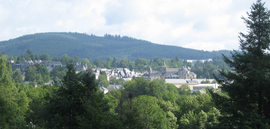 A general view of Meymac | |
 Coat of arms | |
Location of Meymac  | |
 Meymac  Meymac | |
| Coordinates: 45°32′12″N 2°08′52″E | |
| Country | France |
| Region | Nouvelle-Aquitaine |
| Department | Corrèze |
| Arrondissement | Ussel |
| Canton | Plateau de Millevaches |
| Intercommunality | Haute-Corrèze Communauté |
| Government | |
| • Mayor (2020–2026) | Philippe Brugère |
| Area 1 | 87.15 km2 (33.65 sq mi) |
| Population | 2,308 |
| • Density | 26/km2 (69/sq mi) |
| Time zone | UTC+01:00 (CET) |
| • Summer (DST) | UTC+02:00 (CEST) |
| INSEE/Postal code | 19136 /19250 |
| Elevation | 593–973 m (1,946–3,192 ft) |
| 1 French Land Register data, which excludes lakes, ponds, glaciers > 1 km2 (0.386 sq mi or 247 acres) and river estuaries. | |
History
During the Hundred Years' War it was pillaged by Rodrigo de Villandrando.
Geography
The commune lies just south of the Millevaches Plateau and northwest of the Cantal mountains.
The Luzège has its source in the northern part of the commune; it flows south through the middle of the commune and crosses the town. The Triouzoune forms most of the commune's eastern boundary.
Meymac station has rail connections to Limoges, Brive-la-Gaillarde, Ussel and Bordeaux.
Population
| Year | Pop. | ±% |
|---|---|---|
| 1962 | 2,411 | — |
| 1968 | 2,410 | −0.0% |
| 1975 | 2,434 | +1.0% |
| 1982 | 2,523 | +3.7% |
| 1990 | 2,796 | +10.8% |
| 1999 | 2,623 | −6.2% |
| 2008 | 2,625 | +0.1% |

Sights
- Arboretum du Puy Chabrol
- Douglaseraie des Farges
- Mont Bessou viewing tower
See also
References
- "Populations légales 2019". The National Institute of Statistics and Economic Studies. 29 December 2021.
External links
| Wikimedia Commons has media related to Meymac. |
- (in French) Meymac and the Mont Bessou, its observation tower, photos of the panorama and the surroundings
This Corrèze geographical article is a stub. You can help Wikipedia by expanding it. |
На других языках
- [en] Meymac
[ru] Мемак
Мема́к (фр. Meymac, окс. Maismac) — коммуна во Франции, находится в регионе Лимузен. Департамент — Коррез. Административный центр кантона Мемак. Округ коммуны — Юссель.Текст в блоке "Читать" взят с сайта "Википедия" и доступен по лицензии Creative Commons Attribution-ShareAlike; в отдельных случаях могут действовать дополнительные условия.
Другой контент может иметь иную лицензию. Перед использованием материалов сайта WikiSort.org внимательно изучите правила лицензирования конкретных элементов наполнения сайта.
Другой контент может иметь иную лицензию. Перед использованием материалов сайта WikiSort.org внимательно изучите правила лицензирования конкретных элементов наполнения сайта.
2019-2026
WikiSort.org - проект по пересортировке и дополнению контента Википедии
WikiSort.org - проект по пересортировке и дополнению контента Википедии