world.wikisort.org - France
Hérisson (French pronunciation: [eʁisɔ̃]; Occitan: Eiriçon) is a town in the Allier department in central France.
This article may be expanded with text translated from the corresponding article in French. (December 2008) Click [show] for important translation instructions.
|
Hérisson | |
|---|---|
Commune | |
 A general view of Hérisson | |
 Coat of arms | |
Location of Hérisson  | |
 Hérisson  Hérisson | |
| Coordinates: 46°30′34″N 2°42′44″E | |
| Country | France |
| Region | Auvergne-Rhône-Alpes |
| Department | Allier |
| Arrondissement | Montluçon |
| Canton | Huriel |
| Intercommunality | Pays de Tronçais |
| Government | |
| • Mayor (2020–2026) | Stéphanie Cusin-Panit[1] |
| Area 1 | 32.57 km2 (12.58 sq mi) |
| Population | 620 |
| • Density | 19/km2 (49/sq mi) |
| Time zone | UTC+01:00 (CET) |
| • Summer (DST) | UTC+02:00 (CEST) |
| INSEE/Postal code | 03127 /03190 |
| Elevation | 177–327 m (581–1,073 ft) (avg. 199 m or 653 ft) |
| 1 French Land Register data, which excludes lakes, ponds, glaciers > 1 km2 (0.386 sq mi or 247 acres) and river estuaries. | |
Population
| Year | Pop. | ±% |
|---|---|---|
| 1962 | 916 | — |
| 1968 | 1,043 | +13.9% |
| 1975 | 979 | −6.1% |
| 1982 | 872 | −10.9% |
| 1990 | 801 | −8.1% |
| 1999 | 709 | −11.5% |
| 2008 | 676 | −4.7% |
| 2012 | 636 | −5.9% |
| Source: INSEE | ||
Notable people
- Henri Harpignies (28 June 1819 – 28 August 1916), 19th century painter of the Barbizon school who made many pictures of Hérisson and the surroundings.
- Louis Bignon (26 June 1816 - 18 May 1906), restaurateur, who made the Café Riche the most fashionable in Paris.
- Olivier Perrier (born 15 September 1940), actor, codirector of the "Théâtre des Fédérés".
Gallery
 Church of Notre-Dame
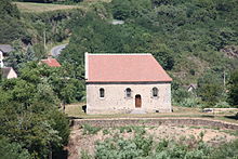 Chapelle du Calvaire
 Église de Châteloy


 Église de Châteloy: Interior
 Église de Châteloy: Fresco
 Old church of église Saint-Sauveur
 Porte de Varenne


See also
References
- "Répertoire national des élus: les maires". data.gouv.fr, Plateforme ouverte des données publiques françaises (in French). 2 December 2020.
- "Populations légales 2019". The National Institute of Statistics and Economic Studies. 29 December 2021.
Wikimedia Commons has media related to Hérisson.
| Authority control |
|
|---|
This Allier geographical article is a stub. You can help Wikipedia by expanding it. |
На других языках
- [en] Hérisson
[ru] Эриссон (Алье)
Эриссо́н (фр. Hérisson) — коммуна во Франции, находится в регионе Овернь. Департамент коммуны — Алье. Административный центр кантона Эриссон. Округ коммуны — Монлюсон.Текст в блоке "Читать" взят с сайта "Википедия" и доступен по лицензии Creative Commons Attribution-ShareAlike; в отдельных случаях могут действовать дополнительные условия.
Другой контент может иметь иную лицензию. Перед использованием материалов сайта WikiSort.org внимательно изучите правила лицензирования конкретных элементов наполнения сайта.
Другой контент может иметь иную лицензию. Перед использованием материалов сайта WikiSort.org внимательно изучите правила лицензирования конкретных элементов наполнения сайта.
2019-2026
WikiSort.org - проект по пересортировке и дополнению контента Википедии
WikiSort.org - проект по пересортировке и дополнению контента Википедии