world.wikisort.org - France
Gentioux-Pigerolles (French pronunciation: [ʒãsju piʒʁɔl]; Occitan: Genciòus) is a commune in the Creuse department in the Nouvelle-Aquitaine region in central France.
Gentioux-Pigerolles | |
|---|---|
Commune | |
 The church seen from behind the Royal Notary hotel | |
 Coat of arms | |
Location of Gentioux-Pigerolles  | |
 Gentioux-Pigerolles  Gentioux-Pigerolles | |
| Coordinates: 45°47′07″N 1°59′42″E | |
| Country | France |
| Region | Nouvelle-Aquitaine |
| Department | Creuse |
| Arrondissement | Aubusson |
| Canton | Felletin |
| Intercommunality | CC Creuse Grand Sud |
| Government | |
| • Mayor (2021–2026) | Benjamin Simons[1] |
| Area 1 | 79.29 km2 (30.61 sq mi) |
| Population | 378 |
| • Density | 4.8/km2 (12/sq mi) |
| Time zone | UTC+01:00 (CET) |
| • Summer (DST) | UTC+02:00 (CEST) |
| INSEE/Postal code | 23090 /23340 |
| Elevation | 653–929 m (2,142–3,048 ft) (avg. 800 m or 2,600 ft) |
| 1 French Land Register data, which excludes lakes, ponds, glaciers > 1 km2 (0.386 sq mi or 247 acres) and river estuaries. | |
Geography
An area of lakes, forestry, quarries and farming, comprising three villages and several hamlets situated in the upper valleys of both the Maulde and Thaurion rivers, some 15 miles (24 km) southwest of Aubusson, at the junction of the D8, D992, D35 and the D16 roads. The commune is in the national park of the Millevaches (1000 lakes, not cows).
Population
| Year | Pop. | ±% |
|---|---|---|
| 1962 | 634 | — |
| 1968 | 535 | −15.6% |
| 1975 | 419 | −21.7% |
| 1982 | 371 | −11.5% |
| 1990 | 367 | −1.1% |
| 1999 | 389 | +6.0% |
| 2008 | 380 | −2.3% |
Sights

- The three 12th-century churches at Gentioux, Pallier and Pigerolles.
- A dolmen.
- A Roman bridge over the Thaurion at Senoueix.

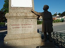
- War memorial: after World War I, some towns in France set up pacifist war memorials. Instead of commemorating the glorious dead, these memorials denounce war with figures of grieving widows and children rather than soldiers. Such memorials provoked anger among veterans and the military in general. The most famous one is located in Gentioux. Below the column which lists the name of the fallen, stands an orphan in bronze pointing to an inscription ‘Maudite soit la guerre’ (war be damned). Feelings ran so high that the memorial was not officially inaugurated until 1990 and soldiers at the nearby army camp were under orders to turn their heads when they walked past.
- An 18th-century house at Pallier, once owned by the notary royal.
- The chapel of Villemoneix, dating from the 18th century.
Gallery
See also
References
- "Répertoire national des élus: les maires" (in French). data.gouv.fr, Plateforme ouverte des données publiques françaises. 4 May 2022.
- "Populations légales 2019". The National Institute of Statistics and Economic Studies. 29 December 2021.
External links
Wikimedia Commons has media related to Gentioux-Pigerolles.
- Website Of the Ski Association of Pigerolles (in French)
На других языках
[de] Gentioux-Pigerolles
Vorlage:Infobox Gemeinde in Frankreich/Wartung/abweichendes Wappen in Wikidata- [en] Gentioux-Pigerolles
[fr] Gentioux-Pigerolles
Gentioux-Pigerolles [ ʒãsju piʒ(ə)ʁɔl][1] (Genciòus e Pijairòu en occitan) est une commune française située dans le département de la Creuse en région Nouvelle-Aquitaine. Sous l'Ancien Régime, le village appartenait au comté de la Marche.[it] Gentioux-Pigerolles
Gentioux-Pigerolles è un comune francese di 397 abitanti situato nel dipartimento della Creuse nella regione della Nuova Aquitania.[ru] Жансью-Пижроль
Жансью́-Пижро́ль (фр. Gentioux-Pigerolles, окс. Genciòus e Pijairòu) — коммуна во Франции, находится в регионе Лимузен. Департамент коммуны — Крёз. Входит в состав кантона Жансью-Пижроль. Округ коммуны — Обюссон.Текст в блоке "Читать" взят с сайта "Википедия" и доступен по лицензии Creative Commons Attribution-ShareAlike; в отдельных случаях могут действовать дополнительные условия.
Другой контент может иметь иную лицензию. Перед использованием материалов сайта WikiSort.org внимательно изучите правила лицензирования конкретных элементов наполнения сайта.
Другой контент может иметь иную лицензию. Перед использованием материалов сайта WikiSort.org внимательно изучите правила лицензирования конкретных элементов наполнения сайта.
2019-2025
WikiSort.org - проект по пересортировке и дополнению контента Википедии
WikiSort.org - проект по пересортировке и дополнению контента Википедии


