world.wikisort.org - Czech
Prášily (German: Stubenbach) is a municipality and village in Klatovy District in the Plzeň Region of the Czech Republic. It has about 100 inhabitants.
Prášily | |
|---|---|
Municipality | |
 Entrance to Prášily from the direction of Srní | |
 Flag  Coat of arms | |
 Prášily Location in the Czech Republic | |
| Coordinates: 49°6′19″N 13°22′41″E | |
| Country | |
| Region | Plzeň |
| District | Klatovy |
| Founded | 1732 |
| Area | |
| • Total | 112.33 km2 (43.37 sq mi) |
| Elevation | 880 m (2,890 ft) |
| Population (2022-01-01)[1] | |
| • Total | 146 |
| • Density | 1.3/km2 (3.4/sq mi) |
| Time zone | UTC+1 (CET) |
| • Summer (DST) | UTC+2 (CEST) |
| Postal code | 342 01 |
| Website | www |
Administrative parts
The village of Nová Hůrka is an administrative part of Prášily.
Geography
Prášily is located about 34 kilometres (21 mi) south of Klatovy, 72 km (45 mi) south of Plzeň, and 132 km (82 mi) southwest of Prague. It lies in the Bohemian Forest.
With the area of 112.33 km2 it is the largest municipality in the country without the town status by size, even though most of Prášily's territory is covered by forests.[2]
Notable people
- Gunther of Bohemia (c. 955–1045), Catholic hermit and diplomat; died in the hermitage on Březník mountain
Gallery
 Sweetshop "Pampeliška"
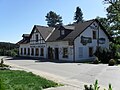 "Hostinec u Michala" inn
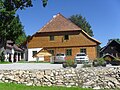 "Brücknerův dům" (Brückner House)
 Memorial of villages destroyed by Czechoslovak army in 1950s
 Classic local timber house


References
- "Population of Municipalities – 1 January 2022". Czech Statistical Office. 2022-04-29.
- Hejna, Petr (23 October 2017). "Šumavské Prášily oplývají četnými zajímavostmi i drží několik prvenství". Novinky.cz.
External links
Wikimedia Commons has media related to Prášily.
Authority control | |
|---|---|
| General |
|
| National libraries | |
This Plzeň Region location article is a stub. You can help Wikipedia by expanding it. |
Текст в блоке "Читать" взят с сайта "Википедия" и доступен по лицензии Creative Commons Attribution-ShareAlike; в отдельных случаях могут действовать дополнительные условия.
Другой контент может иметь иную лицензию. Перед использованием материалов сайта WikiSort.org внимательно изучите правила лицензирования конкретных элементов наполнения сайта.
Другой контент может иметь иную лицензию. Перед использованием материалов сайта WikiSort.org внимательно изучите правила лицензирования конкретных элементов наполнения сайта.
2019-2026
WikiSort.org - проект по пересортировке и дополнению контента Википедии
WikiSort.org - проект по пересортировке и дополнению контента Википедии