world.wikisort.org - Colombia
Ubalá is a municipality and town of Colombia in the department of Cundinamarca. It is located in the Eastern Ranges of the Colombian Andes. It is the only municipality of Cundinamarca that is split in two parts.
Ubalá | |
|---|---|
Municipality and town | |
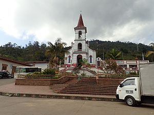
 Church of Ubalá | |
 Flag  Seal | |
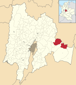 Location of the municipality and town inside Cundinamarca Department of Colombia | |
 Ubalá Location in Colombia | |
| Coordinates: 4°44′38″N 73°32′5″W | |
| Country | |
| Department | |
| Province | Guavio Province |
| Founded | 23 October 1846 |
| Founded by | Ospina Rodríguez |
| Government | |
| • Mayor | Danilo Antonio Salinas Martínez (2016-2019) |
| Area | |
| • Municipality and town | 505 km2 (195 sq mi) |
| Elevation | 1,949 m (6,394 ft) |
| Population (2015) | |
| • Municipality and town | 10,718 |
| • Density | 21/km2 (55/sq mi) |
| • Urban | 1,280 |
| Time zone | UTC-5 (Colombia Standard Time) |
| Website | Official website |
Climate
| Ubalá - 1949 m
| ||||||||||||||||||||||||||||||||||||||||||||||||||||||||||||
|---|---|---|---|---|---|---|---|---|---|---|---|---|---|---|---|---|---|---|---|---|---|---|---|---|---|---|---|---|---|---|---|---|---|---|---|---|---|---|---|---|---|---|---|---|---|---|---|---|---|---|---|---|---|---|---|---|---|---|---|---|
| Climate chart (explanation) | ||||||||||||||||||||||||||||||||||||||||||||||||||||||||||||
| ||||||||||||||||||||||||||||||||||||||||||||||||||||||||||||
| ||||||||||||||||||||||||||||||||||||||||||||||||||||||||||||
Etymology
In the Chibcha language of the Muisca, Ubalá means "Place on the hillside" or "At the foot of the hillside".[1]
History
The region west to Ubalá was inhabited by the Muisca before the Spanish conquistadores entered the Altiplano Cundiboyacense. To the east of Ubalá the indigenous Tegua were living and to the south the Guayupe.
Ubalá was properly founded on October 23rd, 1846 by Ospina Rodríguez.
Economy
Main economical activity of Ubalá is mining, predominantly emeralds, iron ore, sandstones, clay and salt.
Gallery
 Church view
 Church close-up
 Mining iron ore
 Laguna Verde
 Rural part of Ubalá


 Guavio artificial lake
 Guavio river
 Guavio lake
 Edge of Guavio lake


References
Wikimedia Commons has media related to Ubalá.
- (in Spanish) Etymology Ubalá
Provinces and Municipalities in Cundinamarca Department | |
|---|---|
| Almeidas Province | |
| Upper Magdalena Province | |
| Lower Magdalena Province |
|
| Gualivá Province | |
| Guavio Province | |
| Central Magdalena Province | |
| Medina Province | |
| Eastern Province | |
| Rionegro Province | |
| Central Savanna Province | |
| Western Savanna Province |
|
| Soacha Province | |
| Sumapaz Province | |
| Tequendama Province |
|
| Ubaté Province | |
| Metropolitan Area of Bogotá |
|
Mining in Colombia | ||
|---|---|---|
| Gold |
|  |
| Silver | ||
| Platinum | ||
| Nickel |
| |
| Coltan | ||
| Emeralds | ||
| Coal |
| |
| Salt | ||
| Sources | ||
Colombian emeralds | |||||
|---|---|---|---|---|---|
| Geology |
|  | |||
| History |
| ||||
| Main mining areas |
| ||||
| Individual mines |
| ||||
| Individual emeralds (ct) |
| ||||
| Related articles |
| ||||
| |||||
На других языках
- [en] Ubalá
[es] Ubalá
Ubalá es un municipio colombiano del departamento de Cundinamarca, ubicado en la Provincia del Guavio, a 126 km al oriente de Bogotá, y a una altura de 1949 m s. n. m.Текст в блоке "Читать" взят с сайта "Википедия" и доступен по лицензии Creative Commons Attribution-ShareAlike; в отдельных случаях могут действовать дополнительные условия.
Другой контент может иметь иную лицензию. Перед использованием материалов сайта WikiSort.org внимательно изучите правила лицензирования конкретных элементов наполнения сайта.
Другой контент может иметь иную лицензию. Перед использованием материалов сайта WikiSort.org внимательно изучите правила лицензирования конкретных элементов наполнения сайта.
2019-2026
WikiSort.org - проект по пересортировке и дополнению контента Википедии
WikiSort.org - проект по пересортировке и дополнению контента Википедии