world.wikisort.org - Colombia
Tabio is a municipality and town of Colombia in the department of Cundinamarca. It is located at 45 km (28 mi) from Bogotá. The town was officially founded April 8, 1603, by Diego Gómez de Mena, on grounds that were the property of the native Muisca who inhabited the area. Tabio borders Zipaquirá in the north, Cajicá in the east, Subachoque in the west and Tenjo in the south.[1]
Tabio | |
|---|---|
Municipality and town | |
 Central square of Tabio | |
 Flag  Seal | |
 Location of the municipality and town inside Cundinamarca Department of Colombia | |
 Tabio Location in Colombia | |
| Coordinates: 4°54′57″N 74°5′54″W | |
| Country | |
| Department | |
| Province | Central Savanna Province |
| Founded | 8 April 1603 |
| Founded by | Diego Gómez de Mena |
| Government | |
| • Mayor | Rubén Darío Acero García (2016-2019) |
| Area | |
| • Municipality and town | 74.5 km2 (28.8 sq mi) |
| • Urban | 0.43 km2 (0.17 sq mi) |
| Elevation | 2,569 m (8,428 ft) |
| Population (2015) | |
| • Municipality and town | 27,033 |
| • Density | 360/km2 (940/sq mi) |
| • Urban | 13,145 |
| Time zone | UTC-5 (Colombia Standard Time) |
| Website | Official website |
Etymology
The name Tabio comes from the Chibcha word Teib meaning "dent" or "hole", which refers to its geographical location, next to the mouth of the Río Frío (also called Sinca).[1]
History
The Muisca occupied the current location of Tabio before the Spanish conquest, and were largely devoted to agriculture. The Muisca tribe comprised two confederations of small tribes, the Hunza of the northern area, whose sovereign was called zaque, and the Bacatá of the southern area, whose sovereign was the zipa, and which included the territory of Tabio.
The natural hot springs in Tabio were famous among the Muisca, and they were said to have a temple there devoted to the Goddess of Waters. Under the Spanish conquest, the native Muisca were expropriated and the area was put under a colonial rule that issued the foundation of Tabio in 1603.[1]
Economy
Secondary and tertiary economic sectors are relatively underdeveloped in Tabio. Main industrial crops are devoted to floriculture. Potatoes, corn, peas, and carrots are also cultivated.[1]
Tourism
Tabio is well known for its natural hot springs, which are said to have therapeutic properties. It is also known for the annual festival of torbellino, a traditional Andean Colombian dance.[1]
Gallery
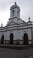 Church of Tabio
 Municipal Forum
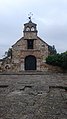 Chapel of St. Barbara
 hot springs


References
- (in Spanish) Official website Tabio
Provinces and Municipalities in Cundinamarca Department | |
|---|---|
| Almeidas Province |
|
| Upper Magdalena Province | |
| Lower Magdalena Province |
|
| Gualivá Province |
|
| Guavio Province |
|
| Central Magdalena Province | |
| Medina Province |
|
| Eastern Province |
|
| Rionegro Province |
|
| Central Savanna Province |
|
| Western Savanna Province |
|
| Soacha Province |
|
| Sumapaz Province |
|
| Tequendama Province |
|
| Ubaté Province |
|
| Metropolitan Area of Bogotá |
|
На других языках
- [en] Tabio
[es] Tabio
Tabio es un municipio colombiano ubicado en el departamento de Cundinamarca. Forma parte de la provincia de Sabana Centro. Se sitúa a 31 kilómetros de Bogotá (desde el Portal de la 80; y 28 kilómetros desde el Portal del Norte). Cuenta con una población de más de 27 000 habitantes en 2015 (proyección). Integra el área metropolitana de Bogotá según el censo oficial del DANE de 2005.Другой контент может иметь иную лицензию. Перед использованием материалов сайта WikiSort.org внимательно изучите правила лицензирования конкретных элементов наполнения сайта.
WikiSort.org - проект по пересортировке и дополнению контента Википедии