world.wikisort.org - Colombia
La Pintada (Spanish pronunciation: [la pinˈtaða]); is a town and municipality in the southwest region of the Antioquia department. It is located seventy nine miles away from Medellín and is at an altitude of six hundred meters over sea level. It borders the Fredonia and Santa Bárbara municipalities to the north. The Cauca River goes through the municipality.
This article does not cite any sources. (January 2013) |
La Pintada | |
|---|---|
Municipality and town | |
 | |
 Flag | |
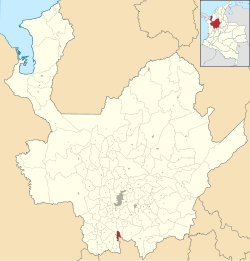 Location of the municipality and town of La Pintada in the Antioquia Department of Colombia | |
 La Pintada Location in Colombia | |
| Coordinates: 5°44′31″N 75°36′19″W | |
| Country | |
| Department | |
| Subregion | Southwestern |
| Elevation | 600 m (2,000 ft) |
| Time zone | UTC-5 (Colombia Standard Time) |
Places of interest
- Slopes of the Poblanco and Arma rivers
- Yellow hill
- Alejandro López railway station
- El Salto del Caballo
- Acapulco beach
Gallery

| Wikimedia Commons has media related to La Pintada. |
Capital: Medellín | |||||||||||||||||||
| Regions and municipalities |
| ||||||||||||||||||
| Related topics |
| ||||||||||||||||||
This Department of Antioquia location article is a stub. You can help Wikipedia by expanding it. |
На других языках
- [en] La Pintada, Antioquia
[ru] Ла-Пинтада (Колумбия)
Ла-Пинтада (исп. La Pintada) — город и муниципалитет на западе Колумбии, на территории департамента Антьокия. Входит в состав субрегиона Юго-западная Антьокия.Текст в блоке "Читать" взят с сайта "Википедия" и доступен по лицензии Creative Commons Attribution-ShareAlike; в отдельных случаях могут действовать дополнительные условия.
Другой контент может иметь иную лицензию. Перед использованием материалов сайта WikiSort.org внимательно изучите правила лицензирования конкретных элементов наполнения сайта.
Другой контент может иметь иную лицензию. Перед использованием материалов сайта WikiSort.org внимательно изучите правила лицензирования конкретных элементов наполнения сайта.
2019-2025
WikiSort.org - проект по пересортировке и дополнению контента Википедии
WikiSort.org - проект по пересортировке и дополнению контента Википедии