world.wikisort.org - Colombia
Abejorral is a town and municipality in Antioquia Department, Colombia. Part of the subregion of Eastern Antioquia.[2] It borders to the north with the municipalities of Montebello, La Ceja and La Unión, to the east with municipality of Sonsón, to the south with the department of Caldas and to the west with the municipalities of Santa Bárbara y Montebello.
This article needs additional citations for verification. (January 2013) |
Abejorral | |
|---|---|
Municipality and town | |
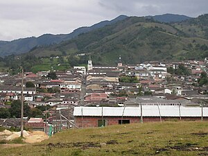
 View of Abejorral | |
 Flag  Seal | |
 Location of the municipality of Abejorral in the Antioquia Department | |
 Abejorral Location in Colombia | |
| Coordinates: 5°47′22″N 75°25′41″W | |
| Country | |
| Region | Andean Region |
| Department | |
| Subregion | Eastern |
| Elevation | 2,275 m (7,464 ft) |
| Population (Census 2018[1]) | |
| • Total | 17,599 |
| Climate | Cfb |
| Website | http://www.abejorral-antioquia.gov.co/ |
It was founded in 1805 by José Antonio Villegas, although some believe it was in 1811.[3] The latter was the year when the titles of the land were officially donated to the then existing residents.[3]
Abejorral is one of the oldest municipalities in the Antioquia Subdivision and Colombia, It is known for its colonial times homes which are part of the Historical National Registry. Its topography is ideal for hiking and cycling activities with beautiful panoramic views of river and valleys; some of them will provide beautiful conditions for wild camping specially along the Arama River or the Aures River. Abejorral has some touristic features highlighted by foreigners as unique like " La Casa en el Aire[4]" and the" Aures River Waterfall ".[5] Another ideas about the options to visit and recommendations are part of this new blog "Orientese"[6]
Sites of interest
Most of the town is a historical site; the architecture that has survived through the years gives Abejorral the aspect of a city "suspended" in the colonial era, which is the reason that a part of the municipality was declared National monument. Sites of interest include:[2]
- Nuestra Señora del Carmen parish church.
- Nuestra Señora de los Dolores chapel.
- Hospital chapel.
- Municipal Cemetery.
- The Ancient Presbytery (Antigua Casa Cural).
- The founder's house (Casa del fundador).
- The Orange House (La Casa Naranjada).
Climate
Abejorral has a subtropical highland climate (Cfb) with cool and rainy weather year-round.
| Climate data for Abejorral | |||||||||||||
|---|---|---|---|---|---|---|---|---|---|---|---|---|---|
| Month | Jan | Feb | Mar | Apr | May | Jun | Jul | Aug | Sep | Oct | Nov | Dec | Year |
| Average high °C (°F) | 20.4 (68.7) |
20.6 (69.1) |
20.9 (69.6) |
20.2 (68.4) |
20.3 (68.5) |
20.7 (69.3) |
20.7 (69.3) |
20.7 (69.3) |
20.6 (69.1) |
19.8 (67.6) |
19.9 (67.8) |
19.8 (67.6) |
20.4 (68.7) |
| Daily mean °C (°F) | 16.4 (61.5) |
16.5 (61.7) |
16.8 (62.2) |
16.4 (61.5) |
16.6 (61.9) |
16.8 (62.2) |
16.5 (61.7) |
16.6 (61.9) |
16.4 (61.5) |
16.0 (60.8) |
16.1 (61.0) |
16.1 (61.0) |
16.4 (61.6) |
| Average low °C (°F) | 12.4 (54.3) |
12.5 (54.5) |
12.8 (55.0) |
12.7 (54.9) |
13.0 (55.4) |
12.9 (55.2) |
12.4 (54.3) |
12.5 (54.5) |
12.2 (54.0) |
12.3 (54.1) |
12.3 (54.1) |
12.4 (54.3) |
12.5 (54.6) |
| Average precipitation mm (inches) | 105 (4.1) |
113 (4.4) |
177 (7.0) |
252 (9.9) |
276 (10.9) |
177 (7.0) |
146 (5.7) |
207 (8.1) |
273 (10.7) |
312 (12.3) |
276 (10.9) |
169 (6.7) |
2,483 (97.7) |
| Source: climate-data.org [7] | |||||||||||||
References
- "Censo Nacional de Población y Vivienda 2018" (in Spanish). DANE. Retrieved 25 April 2020.
- "Alcaldia Municipal de Abejorral" (in Spanish). Retrieved 2018-06-09.
- "Abejorral : generalidades" (in Spanish). 2009-07-29. hdl:10495/423.
{{cite journal}}: Cite journal requires|journal=(help) - "La aventura de pasar la noche en una casa en el aire". ELESPECTADOR.COM (in Spanish). 2016-01-19. Retrieved 2019-08-28.
- "El salto del rio Aures - Bing video". www.bing.com. Retrieved 2019-08-28.
- "Abejorral Turístico". Orientese co (in Spanish). 2016-04-08. Retrieved 2019-08-28.
- "Clima Abejorral: Temperatura, Climograma y Tabla climática para Abejorral". Climate-Data.org (in Spanish). 2015-08-09. Retrieved 2019-05-09.
На других языках
- [en] Abejorral
[es] Abejorral
Abejorral es un municipio de Colombia, localizado en la subregión Oriente del departamento de Antioquia. Limita por el norte con los municipios de Montebello, La Ceja y La Unión, por el este con el municipio de Sonsón, por el sur con el departamento de Caldas y por el oeste con los municipios de Santa Bárbara y Montebello. Su cabecera dista a 86 kilómetros de Medellín, capital del departamento de Antioquia y a 64 kilómetros del aeropuerto internacional José María Córdova. El municipio posee una extensión de 502 kilómetros cuadrados y Cuenta con una población de 20.287 de los cuales 7. 910 viven en la zona urbana y 12.377 en la zona rural, 67 veredas y 2 corregimientos, Abejorral es llamada “La Tierra de Los Cien Señores” por la caudalosa nómina de hombres y mujeres de gran importancia y protagonismo en el desarrollo del país como médicos, ingenieros, religiosos, gobernantes, abogados, escritores, poetas, músicos, grandes maestros, economistas entre otros.[ru] Абехорраль
Абехорраль (исп. Abejorral) — город и муниципалитет на севере Колумбии, на территории департамента Антьокия. Входит в состав субрегиона Восточная Антьокия.Другой контент может иметь иную лицензию. Перед использованием материалов сайта WikiSort.org внимательно изучите правила лицензирования конкретных элементов наполнения сайта.
WikiSort.org - проект по пересортировке и дополнению контента Википедии