world.wikisort.org - China
Huangdao District (Chinese: 黄岛区; lit. 'Yellow Island District') and Xihai'an New Area (Chinese: 西海岸新区; lit. 'West Coast New Area'), also known as Qingdao West Coast is a district and a state-level new area of Qingdao, Shandong, China, located southwest and west of the main urban area of the city on the western shore of Jiaozhou Bay. It was identical to Qingdao Economic and Technological Development Zone (QETDZ, simplified Chinese: 青岛经济技术开发区; traditional Chinese: 青島經濟技術開發區; pinyin: Qīngdǎo Jīngjì Jìshù Kāifā Qū), which was launched in 1985 after the zone was merged with Huangdao District and set up the Free Trade Zone in 1992. In December 2012, Jiaonan, a county-level city in Qingdao was merged into Huangdao District.[1]
Huangdao / Xihai'an
黄岛区 / 西海岸新区 | |
|---|---|
District & State-level new area | |
| Huangdao District / Xihai'an New Area | |
 | |
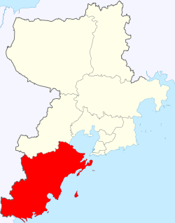 Huangdao / Xihai'an in Qingdao | |
 Huangdao / Xihai'an Location of the district seat in Qingdao  Huangdao / Xihai'an Huangdao / Xihai'an (Shandong) | |
| Coordinates: 35°52′22″N 120°02′46″E | |
| Country | People's Republic of China |
| Province | Shandong |
| Sub-provincial city | Qingdao |
| Township-level divisions | 12 subdistricts 10 towns |
| District seat | Yinzhu Subdistrict (隐珠街道) |
| Area | |
| • Total | 2,220.10 km2 (857.19 sq mi) |
| Elevation | 25 m (83 ft) |
| Population (2019) | |
| • Total | 1,608,200 |
| • Density | 720/km2 (1,900/sq mi) |
| Time zone | UTC+8 (China Standard) |
| Postal code | 266400, 266500 |
| Area code(s) | 0532 |
| Website | HuangDao.gov.cn |
| Huangdao District | |||||||
|---|---|---|---|---|---|---|---|
| Traditional Chinese | 黃島區 | ||||||
| Simplified Chinese | 黄岛区 | ||||||
| Literal meaning | Yellow Island District | ||||||
| |||||||
| Xihai'an New Area | |||||||
| Traditional Chinese | 西海岸新區 | ||||||
| Simplified Chinese | 西海岸新区 | ||||||
| Literal meaning | West Coast New Area | ||||||
| |||||||
The pillar industries engaged in the zone include electronics, household electric appliances, building materials, petrochemicals, machinery and pharmaceutical drugs.[2][3] It is connected via the Jiaozhou Bay Bridge.
In mid 2018, the Ministry of Civil Affairs approved the consolidation of Huangdao District Government and Xihai'an New Area Government into a single governing body, which became the fourth administrative state-level new areas after Pudong of Shanghai; Binhai of Tianjin; and Nansha of Guangzhou. The population was 1.71 million in 2014.
Administrative divisions

Huangdao is divided into 12 subdistricts and 10 more rural towns; the latter half of the current subdistricts and all towns were ceded from Jiaonan City.[4][5]
Subdistricts (街道)
|
|
Towns (镇)
|
|
Transport
Railway Station
Metro
- Line 1
- Line 6 (under construction)
- Line 13
Climate
| Climate data for Huangdao District (1981–2010 normals) | |||||||||||||
|---|---|---|---|---|---|---|---|---|---|---|---|---|---|
| Month | Jan | Feb | Mar | Apr | May | Jun | Jul | Aug | Sep | Oct | Nov | Dec | Year |
| Average high °C (°F) | 3.9 (39.0) |
6.3 (43.3) |
10.9 (51.6) |
17.3 (63.1) |
22.7 (72.9) |
25.8 (78.4) |
28.7 (83.7) |
29.1 (84.4) |
26.2 (79.2) |
20.8 (69.4) |
13.3 (55.9) |
6.5 (43.7) |
17.6 (63.7) |
| Average low °C (°F) | −4.7 (23.5) |
−2.6 (27.3) |
1.7 (35.1) |
7.5 (45.5) |
13.3 (55.9) |
18.1 (64.6) |
22.5 (72.5) |
22.5 (72.5) |
17.6 (63.7) |
11.2 (52.2) |
3.8 (38.8) |
−2.3 (27.9) |
9.1 (48.3) |
| Average precipitation mm (inches) | 11 (0.4) |
16 (0.6) |
26 (1.0) |
31 (1.2) |
68 (2.7) |
86 (3.4) |
151 (5.9) |
201 (7.9) |
74 (2.9) |
39 (1.5) |
31 (1.2) |
11 (0.4) |
745 (29.1) |
| Source: National Meteorological Center of CMA[6] | |||||||||||||
References
- 青岛调整部分行政区划 撤销黄岛区、胶南市等 (in Chinese). Sina Finance. 1 December 2012. Retrieved 2013-01-06.
- Introduction to Qingdao Economic & Technical Development Zone Qingdao Government
- Qingdao Economic and Technological Development Zone chinadaily.com.cn 2006-04-19
- 2011年统计用区划代码和城乡划分代码:黄岛区 (in Chinese). National Bureau of Statistics of the People's Republic of China. Archived from the original on 2013-01-07. Retrieved 2013-01-06.
- 2011年统计用区划代码和城乡划分代码:胶南市 (in Chinese). National Bureau of Statistics of the People's Republic of China. Archived from the original on 2013-01-07. Retrieved 2013-01-06.
- "黄岛-天气预报". China Meteorological Administration. Retrieved 2021-08-27.
External links
Authority control | |
|---|---|
| General | |
| National libraries | |
На других языках
- [en] Huangdao District
[ru] Хуандао
Хуанда́о (кит. упр. 黄岛, пиньинь Huángdǎo) — район городского подчинения города субпровинциального значения Циндао провинции Шаньдун (КНР). Название района означает «жёлтый остров» (имеется в виду, что окружённый морем песчаный остров представлял собой контраст с лежащим восточнее «тёмным островом» Циндао).Другой контент может иметь иную лицензию. Перед использованием материалов сайта WikiSort.org внимательно изучите правила лицензирования конкретных элементов наполнения сайта.
WikiSort.org - проект по пересортировке и дополнению контента Википедии