world.wikisort.org - China
Shen County (simplified Chinese: 莘县; traditional Chinese: 莘縣; pinyin: Shēn Xiàn), or Shenxian, is a county of western Shandong province, People's Republic of China, bordering Henan to the south and southwest and Hebei to the west. It is the southernmost county-level division of the prefecture-level city of Liaocheng.
Shenxian
莘县 | |
|---|---|
County | |
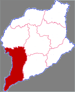 Shen County in Liaocheng | |
 Liaocheng in Shandong | |
| Coordinates (Shen County government): 36°14′02″N 115°40′16″E | |
| Country | People's Republic of China |
| Province | Shandong |
| Prefecture-level city | Liaocheng |
| Township-level divisions | 4 subdistricts 16 towns 4 townships |
| County seat | Yanta Subdistrict (燕塔街道) |
| Area | |
| • Total | 1,420 km2 (550 sq mi) |
| Elevation | 42 m (138 ft) |
| Population | |
| • Total | 982,700 |
| • Density | 690/km2 (1,800/sq mi) |
| Time zone | UTC+8 (China Standard) |
| Postal code | 252400 |
| Area code(s) | 0635 |
| Website | sdsx |
The population was 949,768 in 1999.[3]
Geography and climate
Shen County ranges in latitude from 35° 46' to 36° 25' N and in longitude from 115° 20' to 115° 44' E, reaching 68 kilometres (42 mi) in north-south extent and 32 km (20 mi) in east-west width, and covers an area of 1,387.74 km2 (535.81 sq mi). It borders Guan County and Dongchangfu District to the north, Yanggu County across the Jinxian River (金线河) to the east, Puyang City of Henan to the south, and Handan City of Hebei to the west.
Shen County has a monsoon-influenced, continental semi-arid climate (Köppen BSk) with four distinct seasons. Winters are cold and very dry, with a 24-hour average temperature of −2.0 °C (28.4 °F) in January, while summers are hot and humid, with a 24-hour average temperature of 26.7 °C (80.1 °F) in July; the annual mean is 13.2 °C (55.8 °F). Nearly half of the annual rainfall occurs in July and August alone.
| Climate data for Chaocheng, Shen County (1971–2000), >20 km (12 mi) south of the county seat | |||||||||||||
|---|---|---|---|---|---|---|---|---|---|---|---|---|---|
| Month | Jan | Feb | Mar | Apr | May | Jun | Jul | Aug | Sep | Oct | Nov | Dec | Year |
| Record high °C (°F) | 17.0 (62.6) |
23.7 (74.7) |
28.8 (83.8) |
34.5 (94.1) |
39.8 (103.6) |
41.7 (107.1) |
41.5 (106.7) |
39.8 (103.6) |
34.9 (94.8) |
35.1 (95.2) |
26.7 (80.1) |
21.3 (70.3) |
41.7 (107.1) |
| Average high °C (°F) | 3.8 (38.8) |
7.3 (45.1) |
13.2 (55.8) |
21.0 (69.8) |
26.5 (79.7) |
31.6 (88.9) |
31.5 (88.7) |
30.2 (86.4) |
26.6 (79.9) |
21.0 (69.8) |
12.7 (54.9) |
6.0 (42.8) |
19.3 (66.7) |
| Daily mean °C (°F) | −2.0 (28.4) |
1.0 (33.8) |
7.0 (44.6) |
14.4 (57.9) |
19.9 (67.8) |
25.3 (77.5) |
26.7 (80.1) |
25.3 (77.5) |
20.4 (68.7) |
14.3 (57.7) |
6.4 (43.5) |
0.0 (32.0) |
13.2 (55.8) |
| Average low °C (°F) | −6.5 (20.3) |
−3.8 (25.2) |
1.6 (34.9) |
8.4 (47.1) |
13.8 (56.8) |
19.4 (66.9) |
22.5 (72.5) |
21.2 (70.2) |
15.4 (59.7) |
9.0 (48.2) |
1.5 (34.7) |
−4.3 (24.3) |
8.2 (46.7) |
| Record low °C (°F) | −20 (−4) |
−17.4 (0.7) |
−11.3 (11.7) |
−3.1 (26.4) |
3.3 (37.9) |
8.8 (47.8) |
15.1 (59.2) |
12.7 (54.9) |
3.1 (37.6) |
−2.3 (27.9) |
−18.6 (−1.5) |
−22.7 (−8.9) |
−22.7 (−8.9) |
| Average precipitation mm (inches) | 4.7 (0.19) |
6.7 (0.26) |
15.9 (0.63) |
23.2 (0.91) |
46.1 (1.81) |
66.8 (2.63) |
145.9 (5.74) |
114.6 (4.51) |
47.8 (1.88) |
34.7 (1.37) |
13.6 (0.54) |
6.2 (0.24) |
526.2 (20.71) |
| Average precipitation days (≥ 0.1mm) | 2.0 | 2.6 | 4.2 | 4.9 | 6.0 | 7.7 | 11.6 | 9.0 | 6.3 | 5.1 | 3.6 | 2.6 | 65.6 |
| Source: Weather China[4] | |||||||||||||
Administrative divisions
There are 4 subdistricts, 16 towns and 4 townships in the county:[5]
Subdistricts
- Yanta Subdistrict (燕塔街道)
- Shenting Subdistrict (莘亭街道)
- Shenzhou Subdistrict (莘州街道)
- Donglu Subdistrict (东鲁街道)
Towns
Townships
- Zudian Township (俎店乡)
- Xuzhuang Township (徐庄乡)
- Wangzhuangji Township (王庄集乡)
- Shiziyuan Township (柿子园乡)
- Meizhong Township (妹冢乡)
Historical monuments
- Han Family Tombs (韩氏家族墓地), a monumental complex at the graves of the local Tang-era jiedushi Han Yunzhong and his relatives. The complex includes a pair of giant tortoise-borne stelae (reminiscent of those at Shou Qiu) and other assorted statuary, in the spirit way tradition. It is on the national list of major historical and cultural sites. The complex is located at 36°11′11″N 115°30′44″E, near Liangpiying Village (梁丕营村) of Dongduzhuang Town (董杜庄镇).[6][7]
- Tomb of Ma Benzhai (1902—1944), the leader of a Hui volunteer unit that fought against the Japanese invaders in the Second Sino-Japanese War.[7]
References
- 最新人口信息 www.hongheiku.com (in Chinese). hongheiku. Retrieved 2021-01-12.
- 最新人口信息 www.hongheiku.com (in Chinese). hongheiku. Retrieved 2021-01-12.
- National Population Statistics Materials by County and City - 1999 Period, in China County & City Population 1999, Harvard China Historical GIS
- 莘县气候背景分析. Weather China (in Simplified Chinese). 中国气象局公共气象服务中心. Retrieved 2012-12-12.
- 2011年统计用区划代码和城乡划分代码:莘县 (in Simplified Chinese). National Bureau of Statistics of the People's Republic of China. Archived from the original on February 19, 2013. Retrieved 2013-01-09.
- 韩王墓 (Tombs of Princes Han).
- 莘县韩氏家族墓地、马本斋烈士陵园游记 [A trip to Han Family Tombs and the Tomb of the Hero Ma Benzhai in Shen County]. 163.com (in Simplified Chinese). Archived from the original on 2013-12-26. Retrieved 2013-06-01.
External links
На других языках
- [en] Shen County
[ru] Шэньсянь
Шэнься́нь[1] (кит. упр. 莘县, пиньинь Shēn xiàn) — уезд городского округа Ляочэн провинции Шаньдун (КНР).Другой контент может иметь иную лицензию. Перед использованием материалов сайта WikiSort.org внимательно изучите правила лицензирования конкретных элементов наполнения сайта.
WikiSort.org - проект по пересортировке и дополнению контента Википедии