world.wikisort.org - Brazil
The Mesoregion of Araçatuba is one of the 15 mesoregions of the São Paulo state, Brazil. It is located at the northwest portion of the state, and has an area of 16,768.1 km².
Mesoregion of Araçatuba | |
|---|---|
Mesoregion | |
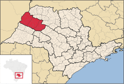 Location of the Mesoregion of Araçatuba | |
| Coordinates: 20°48′29″S 49°22′52″W | |
| Country | |
| Region | Southeast |
| State | |
| Area | |
| • Total | 16,768.1 km2 (6,474.2 sq mi) |
| Population (2010/IBGE) | |
| • Total | 695,801 |
| • Density | 41.50/km2 (107.5/sq mi) |
| Time zone | UTC-3 (UTC-3) |
| • Summer (DST) | UTC-2 (UTC-2) |
| Area code(s) | +55 18 |
The population of the mesoregion is 695,801[1] inhabitants (IBGE/2010), spread over 36 municipalities.
Municipalities
All data from IBGE/2010[1]
Microregion of Andradina
- Population: 190,536
- Area (km²): 6,891.6
- Population density (km²): 26.37
Andradina, Castilho, Guaraçaí, Ilha Solteira, Itapura, Mirandópolis, Murutinga do Sul, Nova Independência, Pereira Barreto, Sud Mennucci, Suzanápolis
Microregion of Araçatuba
- Population: 256,560
- Area (km²): 5,365.6
- Population density (km²): 47.82
Araçatuba, Bento de Abreu, Guararapes, Lavínia, Rubiácea, Santo Antônio do Aracanguá, Valparaíso
Microregion of Birigüi
- Population: 257,531
- Area (km²): 4,510.9
- Population density (km²): 57.09
Alto Alegre, Avanhandava, Barbosa, Bilac, Birigüi, Braúna, Brejo Alegre, Buritama, Clementina, Coroados, Gabriel Monteiro, Glicério, Lourdes, Luiziânia, Penápolis, Piacatu, Santópolis do Aguapeí, Turiúba
References
- "2010 Census of the IBGE - Synopsis - Tables 761 and 1301 - Search" (in Portuguese). IBGE.gov.br. Retrieved 1 Aug 2011.
| |
|---|---|
| Mesoregions |
|
| Microregions |
|
This geographical article relating to the state of São Paulo is a stub. You can help Wikipedia by expanding it. |
Другой контент может иметь иную лицензию. Перед использованием материалов сайта WikiSort.org внимательно изучите правила лицензирования конкретных элементов наполнения сайта.
WikiSort.org - проект по пересортировке и дополнению контента Википедии