world.wikisort.org - Belgium
Stabroek (Dutch pronunciation: [ˈstaːbruk]) is a municipality located in the Belgian province of Antwerp. The municipality comprises the towns of Hoevenen and Stabroek proper. In 2021, Stabroek had a total population of 18,680.[2] The total area is 21.51 km². In 2008 Stabroek celebrated its 750-year-old existence.

- Georgetown, Guyana was known as Stabroek prior to 1812.
Stabroek | |
|---|---|
Municipality | |
 | |
 Flag  Coat of arms | |
 Stabroek Location in Belgium
Location of Stabroek in the province of Antwerp 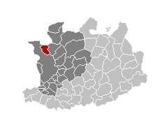 | |
| Coordinates: 51°20′N 04°22′E | |
| Country | Belgium |
| Community | Flemish Community |
| Region | Flemish Region |
| Province | Antwerp |
| Arrondissement | Antwerp |
| Government | |
| • Mayor | Rik Frans (N-VA) |
| • Governing party/ies | N-VA, CD&V |
| Area | |
| • Total | 21.51 km2 (8.31 sq mi) |
| Population (2018-01-01)[1] | |
| • Total | 18,529 |
| • Density | 860/km2 (2,200/sq mi) |
| Postal codes | 2940 |
| Area codes | 03 |
| Website | www.stabroek.be |
Famous inhabitants
- Thomas Vermaelen, retired Belgian football player, currently assistant coach for the Belgium national football team
References
- "Wettelijke Bevolking per gemeente op 1 januari 2018". Statbel. Retrieved 9 March 2019.
- "Bevolking per statistische sector - Sector 11044". Statistics Belgium. Retrieved 10 May 2022.
External links
 Media related to Stabroek at Wikimedia Commons
- (in Dutch) Official website
- (in Dutch) Official website for the 750-year anniversary
Places adjacent to Stabroek | ||||||||||||||||
|---|---|---|---|---|---|---|---|---|---|---|---|---|---|---|---|---|
| ||||||||||||||||
Municipalities in Antwerp Province, Flanders, Belgium | ||
|---|---|---|
| Antwerp |  | |
| Mechelen |
| |
| Turnhout |
| |
Authority control | |
|---|---|
| General |
|
| Other |
|
This Antwerp Province location article is a stub. You can help Wikipedia by expanding it. |
На других языках
- [en] Stabroek
[ru] Стабрук
Стабрук (нидерл. Stabroek) — коммуна в Бельгии, в провинции Антверпен Фламандского региона. Состоит из населённых пунктов Хувенен (Hoevenen) и Стабрук. По статистическим данным от 1 января 2015 года, население коммуны — 18 047 человек.Текст в блоке "Читать" взят с сайта "Википедия" и доступен по лицензии Creative Commons Attribution-ShareAlike; в отдельных случаях могут действовать дополнительные условия.
Другой контент может иметь иную лицензию. Перед использованием материалов сайта WikiSort.org внимательно изучите правила лицензирования конкретных элементов наполнения сайта.
Другой контент может иметь иную лицензию. Перед использованием материалов сайта WikiSort.org внимательно изучите правила лицензирования конкретных элементов наполнения сайта.
2019-2026
WikiSort.org - проект по пересортировке и дополнению контента Википедии
WikiSort.org - проект по пересортировке и дополнению контента Википедии