world.wikisort.org - Belgium
Borsbeek (Dutch pronunciation: [ˈbɔrzbeːk]) is a municipality (![]() Dutch pronunciation) located in Flanders, one of the three regions of Belgium, and in the Flemish province of Antwerp. The municipality only comprises the town of Borsbeek proper. On 1 January 2021 Borsbeek had a total population of 11,076. The total area is 3.92 km² which gives a population density of 2.825 inhabitants per km².
Dutch pronunciation) located in Flanders, one of the three regions of Belgium, and in the Flemish province of Antwerp. The municipality only comprises the town of Borsbeek proper. On 1 January 2021 Borsbeek had a total population of 11,076. The total area is 3.92 km² which gives a population density of 2.825 inhabitants per km².
Borsbeek | |
|---|---|
Municipality | |
 | |
 Flag  Coat of arms | |
 Borsbeek Location in Belgium
Location of Borsbeek in the province of Antwerp  | |
| Coordinates: 51°12′N 04°29′E | |
| Country | Belgium |
| Community | Flemish Community |
| Region | Flemish Region |
| Province | Antwerp |
| Arrondissement | Antwerp |
| Government | |
| • Mayor | Dis Van Berckelaer (IB) |
| • Governing party/ies | IB, N-VA |
| Area | |
| • Total | 3.92 km2 (1.51 sq mi) |
| Population (2018-01-01)[1] | |
| • Total | 10,685 |
| • Density | 2,700/km2 (7,100/sq mi) |
| Postal codes | 2150 |
| Area codes | 03 |
| Website | www.borsbeek.be |
On 28 January 2022, the mayors of Borsbeek and Antwerp announced they intend to merge: the small, densely populated town of Borsbeek might become the 10th district of the city of Antwerp by 2025.
History
Borsbeek was first mentioned in 1232. In 1264, it becomes an independent parish. Until the 16th century, it was part of the County of Cantecroy. In the late 16th century, during the Dutch Revolt, Borsbeek was pillaged and destroyed several times. In 1746, the village was nearly wiped out during the War of the Austrian Succession. Borsbeek used to be an agricultural community. In the mid 20th century, it became a centre of horticulture and a residential town.[2]
Climate
| Climate data for Borsbeek (1991−2020 normals) | |||||||||||||
|---|---|---|---|---|---|---|---|---|---|---|---|---|---|
| Month | Jan | Feb | Mar | Apr | May | Jun | Jul | Aug | Sep | Oct | Nov | Dec | Year |
| Average high °C (°F) | 6.6 (43.9) |
7.6 (45.7) |
11.1 (52.0) |
15.3 (59.5) |
18.9 (66.0) |
21.6 (70.9) |
23.7 (74.7) |
23.5 (74.3) |
20.0 (68.0) |
15.3 (59.5) |
10.3 (50.5) |
7.0 (44.6) |
15.1 (59.2) |
| Daily mean °C (°F) | 3.9 (39.0) |
4.3 (39.7) |
6.9 (44.4) |
10.2 (50.4) |
14.0 (57.2) |
16.9 (62.4) |
19.0 (66.2) |
18.6 (65.5) |
15.3 (59.5) |
11.3 (52.3) |
7.2 (45.0) |
4.4 (39.9) |
11.0 (51.8) |
| Average low °C (°F) | 1.1 (34.0) |
1.0 (33.8) |
2.7 (36.9) |
5.0 (41.0) |
9.1 (48.4) |
12.2 (54.0) |
14.2 (57.6) |
13.7 (56.7) |
10.7 (51.3) |
7.3 (45.1) |
4.1 (39.4) |
1.8 (35.2) |
6.9 (44.4) |
| Average precipitation mm (inches) | 69.9 (2.75) |
61.5 (2.42) |
55.3 (2.18) |
42.3 (1.67) |
59.5 (2.34) |
73.9 (2.91) |
79.3 (3.12) |
85.1 (3.35) |
72.3 (2.85) |
66.8 (2.63) |
77.3 (3.04) |
91.4 (3.60) |
834.6 (32.86) |
| Average precipitation days (≥ 1.0 mm) | 12.4 | 11.1 | 10.4 | 8.6 | 9.7 | 10.0 | 10.3 | 10.5 | 9.7 | 10.8 | 12.5 | 13.9 | 129.9 |
| Mean monthly sunshine hours | 59 | 77 | 134 | 190 | 219 | 219 | 225 | 211 | 164 | 116 | 65 | 50 | 1,729 |
| Source: Royal Meteorological Institute[3] | |||||||||||||
Notable people
See the Category:People from Borsbeek.
Gallery
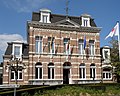 Town hall
 Water tower of Borsbeek
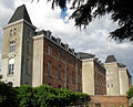 St Josef Institute
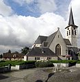 St Jacobs Church


References
- "Wettelijke Bevolking per gemeente op 1 januari 2018". Statbel. Retrieved 9 March 2019.
- "Borsbeek". Agentschap Onroerend Erfgoed (in Dutch). Retrieved 11 May 2022.
- "Luchttemperatuur en neerslag Referentieperiode: 1991-2020" (PDF) (in Dutch). Royal Meteorological Institute. Retrieved 9 July 2022.
External links
 Media related to Borsbeek at Wikimedia Commons
- (in Dutch) Official website
Places adjacent to Borsbeek | ||||||||||||||||
|---|---|---|---|---|---|---|---|---|---|---|---|---|---|---|---|---|
| ||||||||||||||||
Municipalities in Antwerp Province, Flanders, Belgium | ||
|---|---|---|
| Antwerp |  | |
| Mechelen |
| |
| Turnhout |
| |
Authority control | |
|---|---|
| General |
|
| Other |
|
This Antwerp Province location article is a stub. You can help Wikipedia by expanding it. |
Другой контент может иметь иную лицензию. Перед использованием материалов сайта WikiSort.org внимательно изучите правила лицензирования конкретных элементов наполнения сайта.
WikiSort.org - проект по пересортировке и дополнению контента Википедии