world.wikisort.org - Belgium
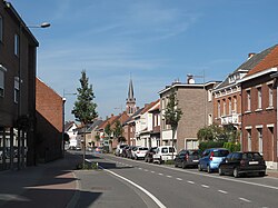
Merksplas (Dutch pronunciation: [ˈmɛr(ə)ksplɑs]) is a municipality located in the Belgian province of Antwerp. The municipality comprises only the town of Merksplas proper. In 2021, Merksplas had a total population of 8,616.[2] The total area is 44.56 km².
Merksplas | |
|---|---|
Municipality | |
 | |
 Flag  Coat of arms | |
 Merksplas Location in Belgium
Location of Merksplas in the province of Antwerp  | |
| Coordinates: 51°22′N 04°52′E | |
| Country | Belgium |
| Community | Flemish Community |
| Region | Flemish Region |
| Province | Antwerp |
| Arrondissement | Turnhout |
| Government | |
| • Mayor | Frank Wilrycx (Leefbaar Merksplas) |
| • Governing party/ies | Leefbaar Merksplas |
| Area | |
| • Total | 44.56 km2 (17.20 sq mi) |
| Population (2018-01-01)[1] | |
| • Total | 8,619 |
| • Density | 190/km2 (500/sq mi) |
| Postal codes | 2330 |
| Area codes | 014, 03 |
| Website | www.merksplas.be |
References
- "Wettelijke Bevolking per gemeente op 1 januari 2018". Statbel. Retrieved 9 March 2019.
- "Bevolking per statistische sector - Sector 12030D". Statistics Belgium. Retrieved 10 May 2022.
External links
 Media related to Merksplas at Wikimedia Commons
- Official website - Available only in Dutch
Текст в блоке "Читать" взят с сайта "Википедия" и доступен по лицензии Creative Commons Attribution-ShareAlike; в отдельных случаях могут действовать дополнительные условия.
Другой контент может иметь иную лицензию. Перед использованием материалов сайта WikiSort.org внимательно изучите правила лицензирования конкретных элементов наполнения сайта.
Другой контент может иметь иную лицензию. Перед использованием материалов сайта WikiSort.org внимательно изучите правила лицензирования конкретных элементов наполнения сайта.
2019-2025
WikiSort.org - проект по пересортировке и дополнению контента Википедии
WikiSort.org - проект по пересортировке и дополнению контента Википедии
