world.wikisort.org - Belgium
Lievegem is a municipality in the Belgian province of East Flanders that arose on 1 January 2019 from the merging of the municipalities of Waarschoot, Lovendegem and Zomergem.[2]
Lievegem | |
|---|---|
Municipality | |
 Flag  Coat of arms | |
 Lievegem Location in Belgium
Location of the municipality of Lievegem  | |
| Coordinates: 51.13°N 3.58°E | |
| Country | Belgium |
| Community | Flemish Community |
| Region | Flemish Region |
| Province | East Flanders |
| Arrondissement | Ghent |
| Government | |
| • Mayor | Tony Vermeire[1] |
| Area | |
| • Total | 80.17 km2 (30.95 sq mi) |
| Website | lievegem.be |
The merged municipality has an area of 80.78 km² and is home to 26,441 inhabitants as of 2021.[3] A referendum was held for the new name of the municipality, and 55% voted for Lievegem (English: sweet settlement).[4]
Lievegem consists of the following deelgemeentes (sub-municipalities): Lovendegem, Oostwinkel, Ronsele, Vinderhoute, Waarschoot, and Zomergem.[5]
Gallery
 St. Martin's church in Zomergem
 Brewery in Beke
 Rectory in Zomergem
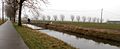 The Lieve River


References
- "Verkozen kandidaten 2018 - Lievegem gemeenteraad". Vlaanderen kiest (in Dutch). Retrieved 5 May 2022.
- "Drie kleintjes zijn liever samen groot: in 2019 worden inwoners wakker in Lievegem". Nieuwsblad (in Dutch). Retrieved 5 May 2022.
- "Bevolking per statistische sector - Sector 44036". Statistics Belgium. Retrieved 5 May 2022.
- "Lovendegem, Zomergem en Waarschoot smelten samen tot Lievegem". Vlaamse Radio- en Televisieomroeporganisatie (in Dutch). Retrieved 5 May 2022.
- "Lievegem". Vlaanderen.be (in Dutch). Retrieved 5 May 2022.
External links
 Media related to Lievegem at Wikimedia Commons
- Official site
Belgian municipality Lievegem | |
|---|---|
| Deelgemeentes |
|
| |
Municipalities in the Province of East Flanders, Flanders, Belgium | ||
|---|---|---|
| Aalst |  | |
| Dendermonde | ||
| Eeklo | ||
| Ghent | ||
| Oudenaarde | ||
| Sint-Niklaas | ||
| Authority control |
|
|---|
This East Flanders location article is a stub. You can help Wikipedia by expanding it. |
На других языках
[de] Lievegem
Lievegem ist eine Gemeinde in der belgischen Provinz Ostflandern, die am 1. Januar 2019 aus dem Zusammenschluss der Gemeinden Waarschoot, Lovendegem und Zomergem entstand.- [en] Lievegem
Текст в блоке "Читать" взят с сайта "Википедия" и доступен по лицензии Creative Commons Attribution-ShareAlike; в отдельных случаях могут действовать дополнительные условия.
Другой контент может иметь иную лицензию. Перед использованием материалов сайта WikiSort.org внимательно изучите правила лицензирования конкретных элементов наполнения сайта.
Другой контент может иметь иную лицензию. Перед использованием материалов сайта WikiSort.org внимательно изучите правила лицензирования конкретных элементов наполнения сайта.
2019-2026
WikiSort.org - проект по пересортировке и дополнению контента Википедии
WikiSort.org - проект по пересортировке и дополнению контента Википедии