world.wikisort.org - Belgium
Bassenge (French pronunciation: [basɑ̃ʒ]; Dutch: Bitsingen, Dutch pronunciation: [ˈbɪtsɪŋə(n)] (![]() listen); Walloon: Bassindje) is a municipality of Wallonia located in the province of liège, Belgium.
listen); Walloon: Bassindje) is a municipality of Wallonia located in the province of liège, Belgium.
This article needs additional citations for verification. (March 2013) |
Bassenge
| |
|---|---|
Municipality | |
 | |
 Coat of arms | |
Location of Bassenge  | |
 Bassenge Location in Belgium
Location of Bassenge in Liège province  | |
| Coordinates: 50°46′N 05°36′E | |
| Country | Belgium |
| Community | French Community |
| Region | Wallonia |
| Province | Liège |
| Arrondissement | Liège |
| Government | |
| • Mayor | Valérie Hiance |
| • Governing party/ies | Bassenge Demain (CDH/MR) |
| Area | |
| • Total | 38.17 km2 (14.74 sq mi) |
| Population (2018-01-01)[1] | |
| • Total | 8,986 |
| • Density | 240/km2 (610/sq mi) |
| Postal codes | 4690 |
| Area codes | 04 |
| Website | www.bassenge.be |
On 1 January 2006 Bassenge had a total population of 8,335. The total area is 38.17 km² which gives a population density of 218 inhabitants per km².
The municipality consists of the following districts: Bassenge, Boirs, Ében-Émael, Glons, Roclenge-sur-Geer, and Wonck.
Gallery
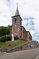 Bassenge, church: l'église Saint-Pierre
 Bassenge, la chapelle du Vi Mosti
 Roclenge sur Geer, l'église Saint-Remy
 Wonck, chapel in the hills


Historic sites
Fort Eben-Emael was a major fortress intended to defend Belgium against attack from Germany. Built in the 1930s, it was swiftly captured by German forces in May 1940 during the Belgian Campaign of the Second World War.
Eben-Ezer Tower, also known as le musée du silex (the museum of flint) is a fantastical tower built of flint rubble in the 1960s by Robert Garcet and decorated with mystical and religious symbols.[2]
See also
- List of protected heritage sites in Bassenge
References
- "Wettelijke Bevolking per gemeente op 1 januari 2018". Statbel. Retrieved 9 March 2019.
- "Tower of Eben-Ezer". Atlas Obscura. Retrieved 2015-06-28.
External links
 Media related to Bassenge at Wikimedia Commons
Municipalities in the province of Liège, Wallonia | ||
|---|---|---|
| Huy |  | |
| Liège | ||
| Verviers | ||
| Waremme | ||
Bold indicates cities · Italic indicates municipalities with language facilities | ||
This Liège Province location article is a stub. You can help Wikipedia by expanding it. |
На других языках
[de] Bassenge (Belgien)
Bassenge (niederl./deutsch: Bitsingen; wallonisch: Bassindje) ist eine Gemeinde in der belgischen Provinz Lüttich.- [en] Bassenge
[ru] Бассанж
Басса́нж (фр. Bassenge, нидерл. Bitsingen) — коммуна в Валлонии, расположенная в провинции Льеж, округ Льеж. Принадлежит Французскому языковому сообществу Бельгии. На площади 38,17 км² проживают 8335 человек (плотность населения — 218 чел./км²), из которых 49,07 % — мужчины и 50,93 % — женщины. Средний годовой доход на душу населения в 2003 году составлял 12 070 евро.Другой контент может иметь иную лицензию. Перед использованием материалов сайта WikiSort.org внимательно изучите правила лицензирования конкретных элементов наполнения сайта.
WikiSort.org - проект по пересортировке и дополнению контента Википедии