world.wikisort.org - Australia
Tanami is an interim Australian bioregion, comprising 25,997,277 hectares (64,240,670 acres) in the Northern Territory and Western Australia.[1] It is part of the Great Sandy-Tanami desert ecoregion.
| Tanami Australia | |||||||||||||||
|---|---|---|---|---|---|---|---|---|---|---|---|---|---|---|---|
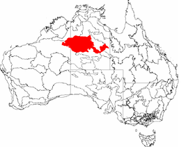 The interim Australian bioregions, with Tanami in red | |||||||||||||||
| Area | 259,972.77 km2 (100,376.0 sq mi) | ||||||||||||||
| |||||||||||||||
The bioregion has the code TAN.[2] There are three subregions.[2]
| IBRA regions and subregions: IBRA7 | ||||
|---|---|---|---|---|
| IBRA region / subregion | IBRA code | Area | States | Location in Australia |
| Tanami | TAN | 25,997,277 hectares (64,240,670 acres) | NT / WA |  |
| Tanami Desert | TAN01 | 20,769,151 hectares (51,321,690 acres) | ||
| Wycliffe | TAN02 | 1,600,893 hectares (3,955,890 acres) | ||
| Sandover | TAN03 | 3,627,233 hectares (8,963,090 acres) | ||
See also
- Geography of Australia
References
- Environment Australia. "Revision of the Interim Biogeographic Regionalisation for Australia (IBRA) and Development of Version 5.1 – Summary Report" (PDF). Department of the Environment and Water Resources, Government of Australia. Retrieved 9 May 2022.
{{cite journal}}: Cite journal requires|journal=(help) - "Interim Biogeographic Regionalisation for Australia (IBRA7) regions and codes". Department of Sustainability, Environment, Water, Population and Communities. Commonwealth of Australia. 2012. Retrieved 13 January 2013.
Further reading
- Thackway, R and I D Cresswell (1995) An interim biogeographic regionalisation for Australia : a framework for setting priorities in the National Reserves System Cooperative Program Version 4.0 Canberra : Australian Nature Conservation Agency, Reserve Systems Unit, 1995. ISBN 0-642-21371-2
Northern Territory | ||
|---|---|---|
| Topics |
| |
| Regions |
| |
| Major settlements |
| |
Текст в блоке "Читать" взят с сайта "Википедия" и доступен по лицензии Creative Commons Attribution-ShareAlike; в отдельных случаях могут действовать дополнительные условия.
Другой контент может иметь иную лицензию. Перед использованием материалов сайта WikiSort.org внимательно изучите правила лицензирования конкретных элементов наполнения сайта.
Другой контент может иметь иную лицензию. Перед использованием материалов сайта WikiSort.org внимательно изучите правила лицензирования конкретных элементов наполнения сайта.
2019-2026
WikiSort.org - проект по пересортировке и дополнению контента Википедии
WikiSort.org - проект по пересортировке и дополнению контента Википедии