world.wikisort.org - Australia
The Tasmanian South East is an interim Australian bioregion located in the south-eastern region of Tasmania, comprising 1,131,822 hectares (2,796,790 acres).[1][2]
| Tasmanian South East Tasmania | |||||||||||||||
|---|---|---|---|---|---|---|---|---|---|---|---|---|---|---|---|
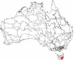 The interim Australian bioregions, with the Tasmanian South East in red | |||||||||||||||
| Area | 1,132 km2 (437.1 sq mi) | ||||||||||||||
| |||||||||||||||
See also
- Ecoregions in Australia
- Interim Biogeographic Regionalisation for Australia
- Regions of Tasmania
References
- "Interim Biogeographic Regionalisation for Australia (IBRA7) regions and codes". Department of Sustainability, Environment, Water, Population and Communities. Australian Government. 2012. Retrieved 13 January 2013.
- "Interim Biogeographic Regionalisation for Australia, Version 7" (PDF). Department of Sustainability, Environment, Water, Population and Communities. Australian Government. 2012. Retrieved 14 April 2015.
Further reading
- Thackway, R.; Cresswell, I. D. (1995). An interim biogeographic regionalisation for Australia : a framework for setting priorities in the National Reserves System Cooperative Program: Version 4.0. Canberra: Australian Nature Conservation Agency, Reserve Systems Unit. ISBN 0-642-21371-2.
Southern region of Tasmania, Australia | |||||
|---|---|---|---|---|---|
| City Other settlements |
| ||||
| Governance |
| ||||
| Mountains | |||||
| Protected areas, parks and reserves |
| ||||
| Rivers | |||||
| Harbours, bays, inlets and estuaries |
| ||||
| Coastal features |
| ||||
| Transport |
| ||||
| Landmarks |
| ||||
| Islands | |||||
| Books and newspapers |
| ||||
| Flora, fauna, and fishlife |
| ||||
| Bioregions | |||||
| Indigenous heritage |
| ||||
| Other |
| ||||
| |||||
East Coast region of Tasmania, Australia | |||||
|---|---|---|---|---|---|
| Settlements | |||||
| Governance former |
| ||||
| Mountains | |||||
| Protected areas, parks and reserves |
| ||||
| Harbours, bays, inlets and estuaries | |||||
| Landmarks |
| ||||
| People of note |
| ||||
| Islands |
| ||||
| Books and newspapers |
| ||||
| Flora, fauna, and fishlife |
| ||||
| Bioregions |
| ||||
| |||||
This Tasmania article is a stub. You can help Wikipedia by expanding it. |
Текст в блоке "Читать" взят с сайта "Википедия" и доступен по лицензии Creative Commons Attribution-ShareAlike; в отдельных случаях могут действовать дополнительные условия.
Другой контент может иметь иную лицензию. Перед использованием материалов сайта WikiSort.org внимательно изучите правила лицензирования конкретных элементов наполнения сайта.
Другой контент может иметь иную лицензию. Перед использованием материалов сайта WikiSort.org внимательно изучите правила лицензирования конкретных элементов наполнения сайта.
2019-2026
WikiSort.org - проект по пересортировке и дополнению контента Википедии
WikiSort.org - проект по пересортировке и дополнению контента Википедии