world.wikisort.org - Australia
Southern Midlands is a local government body in Tasmania, covering the southern region of the Tasmanian central midlands. Southern Midlands is classified as a rural local government area and has a population of 6,118,[1] the major localities of the region include Campania, Kempton, Mangalore and the principal town of Oatlands.
| Southern Midlands Council Tasmania | |||||||||||||||
|---|---|---|---|---|---|---|---|---|---|---|---|---|---|---|---|
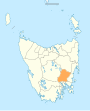
 Map showing the Southern Midlands local government area. | |||||||||||||||
| Coordinates | 42.4346°S 147.4006°E | ||||||||||||||
| Population | 6,118 (2018)[1] | ||||||||||||||
| • Density | 2.3387/km2 (6.0572/sq mi) | ||||||||||||||
| Established | 2 April 1993[2] | ||||||||||||||
| Area | 2,616 km2 (1,010.0 sq mi)[1] | ||||||||||||||
| Mayor | Alex Green | ||||||||||||||
| Council seat | Oatlands | ||||||||||||||
| Region | Southern Midlands region | ||||||||||||||
| State electorate(s) | Lyons | ||||||||||||||
| Federal division(s) | Lyons | ||||||||||||||
| Website | Southern Midlands Council | ||||||||||||||
| |||||||||||||||
History and attributes
On 2 April 1993, Oatlands and Green Ponds were amalgamated with parts of the municipalities of Brighton and Richmond to form the new Southern Midlands Council.[2] Southern Midlands is classified as rural, agricultural and large (RAL) under the Australian Classification of Local Governments.[3]
Localities
• Andover • Antill Ponds • Apsley • Baden • Bagdad • Black Hills • Brighton • Broadmarsh • Campania • Colebrook • Dromedary • Dysart • Elderslie • Interlaken • Jericho • Kempton • Lemont • Levendale • Lower Marshes • Magra • Mangalore • Melton Mowbray • Mount Seymour • Oatlands • Orielton • Parattah • Pawtella • Pelham • Pontville • Rhyndaston • Runnymede • Stonehenge • Stonor • Swanston • Tea Tree • Tiberias • Tooms Lake • Tunbridge • Tunnack • Whitefoord • Woodbury • Woodsdale • York Plains
See also
- List of local government areas of Tasmania
References
- "3218.0 – Regional Population Growth, Australia, 2017-18: Population Estimates by Local Government Area (ASGS 2018), 2017 to 2018". Australian Bureau of Statistics. Australian Bureau of Statistics. 27 March 2019. Retrieved 25 October 2019. Estimated resident population, 30 June 2018.
- "Agency Details: Southern Midlands Municipal Council". search.archives.tas.gov.au. Tasmanian Government. Retrieved 11 June 2018.
- "Local government national report 2014-2015". regional.gov.au. Australian Government. Retrieved 8 June 2018.
External links
- Southern Midlands Council official website
- Local Government Association Tasmania
- Tasmanian Electoral Commission - local government
Другой контент может иметь иную лицензию. Перед использованием материалов сайта WikiSort.org внимательно изучите правила лицензирования конкретных элементов наполнения сайта.
WikiSort.org - проект по пересортировке и дополнению контента Википедии