world.wikisort.org - Australia
Latrobe Council is a local government body in Tasmania, situated in the north of the state, east of Devonport. The Latrobe local government area is classified as rural and has a population of 11,329,[1] it encompasses the principal town, Latrobe, and the nearby localities including Port Sorell, Sassafras and Wesley Vale.
| Latrobe Council Tasmania | |||||||||||||||
|---|---|---|---|---|---|---|---|---|---|---|---|---|---|---|---|
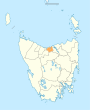
 Map showing the Latrobe local government area. | |||||||||||||||
| Coordinates | 41.2413°S 146.5598°E | ||||||||||||||
| Population | 11,329 (2018)[1] | ||||||||||||||
| • Density | 18.850/km2 (48.82/sq mi) | ||||||||||||||
| Established | 1 January 1907[2] | ||||||||||||||
| Area | 601 km2 (232.0 sq mi)[1] | ||||||||||||||
| Mayor | Peter Freshney | ||||||||||||||
| Council seat | Latrobe | ||||||||||||||
| Region | North West Tasmania | ||||||||||||||
| State electorate(s) | Braddon | ||||||||||||||
| Federal division(s) | Braddon | ||||||||||||||
| Website | Latrobe Council | ||||||||||||||
| |||||||||||||||
History and attributes
The Latrobe municipality was established on 1 January 1907.[2] Latrobe is classified as rural, agricultural and very large (RAV) under the Australian Classification of Local Governments.[3]
Suburbs
| Suburb | Census population 2016 | Reason |
|---|---|---|
| Wesley Vale | 443 | |
| Northdown | 221 | |
| Hawley Beach | 483 | |
| Shearwater | 1,764 | |
| Port Sorell | 2,022 | |
| Squeaking Point | 223 | |
| Thirlstane | 94 | |
| Bakers Beach | 60 | |
| Merseylea | 56 | |
| Sassafras | 347 | |
| Harford | 74 | |
| Moriarty | 223 | |
| Latrobe | 4,169 | |
| Tarleton. | 380 | |
| Total | 10,559 | |
| 140 | Variance | |
| Local government total | 10,699 | Gazetted Central Coast local government area |
Not in above list
See also
- List of local government areas of Tasmania
References
- "3218.0 – Regional Population Growth, Australia, 2017-18: Population Estimates by Local Government Area (ASGS 2018), 2017 to 2018". Australian Bureau of Statistics. Australian Bureau of Statistics. 27 March 2019. Retrieved 25 October 2019. Estimated resident population, 30 June 2018.
- "Agency Details: Latrobe Municipal Council". search.archives.tas.gov.au. Tasmanian Government. Retrieved 11 June 2018.
- "Local government national report 2014-2015". regional.gov.au. Australian Government. Retrieved 8 June 2018.
- Australian Bureau of Statistics. "2016 Census QuickStats". Retrieved 22 July 2017.
External links
- Latrobe Council official website
- Local Government Association Tasmania
- Tasmanian Electoral Commission - local government
На других языках
[de] Latrobe Municipality
-41.233333333333146.41666666667 Die Latrobe Municipality ist ein lokales Verwaltungsgebiet (LGA) im australischen Bundesstaat Tasmanien. Das Gebiet ist 550 km² groß und hat etwa 10.000 Einwohner (2016).- [en] Latrobe Council
Текст в блоке "Читать" взят с сайта "Википедия" и доступен по лицензии Creative Commons Attribution-ShareAlike; в отдельных случаях могут действовать дополнительные условия.
Другой контент может иметь иную лицензию. Перед использованием материалов сайта WikiSort.org внимательно изучите правила лицензирования конкретных элементов наполнения сайта.
Другой контент может иметь иную лицензию. Перед использованием материалов сайта WikiSort.org внимательно изучите правила лицензирования конкретных элементов наполнения сайта.
2019-2025
WikiSort.org - проект по пересортировке и дополнению контента Википедии
WikiSort.org - проект по пересортировке и дополнению контента Википедии