world.wikisort.org - Australia
Seaforth is a coastal town and locality in the Mackay Region, Queensland, Australia.[2][3] In the 2016 census the locality of Seaforth had a population of 789 people.[1]
| Seaforth Queensland | |||||||||||||||
|---|---|---|---|---|---|---|---|---|---|---|---|---|---|---|---|
 View in Seaforth | |||||||||||||||
 Seaforth | |||||||||||||||
| Coordinates | 20.9013°S 148.9675°E | ||||||||||||||
| Population | 789 (2016 census)[1] | ||||||||||||||
| • Density | 11.535/km2 (29.88/sq mi) | ||||||||||||||
| Established | 1899 | ||||||||||||||
| Postcode(s) | 4741 | ||||||||||||||
| Elevation | 0–250 m (0–820 ft) | ||||||||||||||
| Area | 68.4 km2 (26.4 sq mi) | ||||||||||||||
| Time zone | AEST (UTC+10:00) | ||||||||||||||
| Location |
| ||||||||||||||
| LGA(s) | Mackay Region | ||||||||||||||
| State electorate(s) | Mackay | ||||||||||||||
| Federal division(s) | Dawson | ||||||||||||||
| |||||||||||||||
| |||||||||||||||
Geography
Seaforth is a small holiday and fishing town located 35 kilometres (22 mi) north-northwest of Mackay.
Finlaysons Point is a headland at the northernmost of the locality (20.8766°S 148.9509°E).[4] The coastline near the point and extending along the north-east coastline is a sandy beach. The town is beside the beach with most of the residential development in the town or along that stretch of coast.
The southern part of the locality is mountainous, rising to elevations of 250 metres (820 ft) above sea level. The northern part is lower and flatter with typical elevations of 10 to 20 metres (33 to 66 ft) above sea level and used for cropping (mostly sugarcane). Apart from this, the predominant land use is grazing on native vegetation.[5]
Seaforth has the following mountains:
- Mount Springcliffe (20.9089°S 148.9504°E) 116 metres (381 ft)[6][7]
- Mount Sweetland (20.9665°S 148.8938°E) 171 metres (561 ft)[6][8]
and the following mountain passes:
- Macartneys Gap (20.9503°S 148.9281°E)[6]
- Niddoes Gap (20.9695°S 148.9042°E)[6]
Islands off-shore from Seaforth include:
- Redcliff Islands (20.8690°S 148.9599°E)[9]
- Acacia Island (also known as Chings Island) (20.8616°S 148.9285°E).[10][11]
History
In 1899 the Queensland Government bought Seaforth Estate from H.M. Finlayson, a pioneer selector, as a settlement and named it Springcliff; however local residents always called it Seaforth and it was officially renamed Seaforth in 1966.[12] Finlayson Point is named after Finlayson.[4]
Seaforth Provisional School opened on 22 August 1887 and closed in late 1891. A second Seaforth Provisional School opened on 23 April 1935. On 25 October 1948 it became Seaforth State School.[13] The old provisional school building was relocated to become the Seaforth Presbyterian Church, which opened in May 1949 and which served the congregation until May 1961 when the present church was opened. It later became known as the Seaforth Uniting Church after Methodist Church entered into the amalgamation to create the Uniting Church in Australia.[14]
At the 2006 census, Seaforth had a population of 613.[15]
In the 2016 census the locality of Seaforth had a population of 789 people.[1]
There is a former church building at 53 Palm Avenue (20.8993°S 148.9633°E).[16]
Education
Seaforth State School is a government primary (Prep-6) school for boys and girls at 2092 Seaforth Road (20.9210°S 148.9626°E).[17][18] In 2018, the school had an enrolment of 80 students with 8 teachers (6 full-time equivalent) and 9 non-teaching staff (4 full-time equivalent).[19] It includes a special education program.[17]
There is no secondary school in Seaforth. The nearest government secondary schools are Calen District State College in Calen to the west and Mackay North State High School in North Mackay to the south-east.[5]
Amenities
The Mackay Regional Council operates a mobile library service on a fortnightly schedule near the school and at Seaforth Reserve Road.[20][21]
The Seaforth branch of the Queensland Country Women's Association meets at 1-3 Margaret Street (20.9000°S 148.9637°E).[22]
Seaforth Uniting Church is at 43 Palm Avenue (20.8996°S 148.9638°E).[23][24]
Star of the Sea Catholic Church is at 2241 Yakapari-Seaforth Road (20.9080°S 148.9607°E). It is part of the Farleigh parish.[25]
Seaforth Bowls Club is in Walsh Street (20.8976°S 148.9609°E).[26]
References
- Australian Bureau of Statistics (27 June 2017). "Seaforth (SSC)". 2016 Census QuickStats. Retrieved 20 October 2018.
- "Seaforth – town in Mackay Region (entry 30318)". Queensland Place Names. Queensland Government. Retrieved 27 December 2020.
- "Seaforth – locality in Mackay Region (entry 46836)". Queensland Place Names. Queensland Government. Retrieved 27 December 2020.
- "Finlaysons Point – point in Mackay Regional (entry 12446)". Queensland Place Names. Queensland Government. Retrieved 27 December 2020.
- "Queensland Globe". State of Queensland. Retrieved 10 March 2021.
- "Mountain peaks and capes - Queensland". Queensland Open Data. Queensland Government. 12 November 2020. Archived from the original on 25 November 2020. Retrieved 25 November 2020.
- "Mount Springcliffe – mountain in Mackay Region (entry 31988)". Queensland Place Names. Queensland Government. Retrieved 25 November 2020.
- "Mount Sweetland – mountain in Mackay Region (entry 32992)". Queensland Place Names. Queensland Government. Retrieved 25 November 2020.
- "Island groups - Queensland". Queensland Open Data. Queensland Government. 12 November 2020. Archived from the original on 25 November 2020. Retrieved 25 November 2020.
- "Island groups - Queensland". Queensland Open Data. Queensland Government. 12 November 2020. Archived from the original on 25 November 2020. Retrieved 25 November 2020.
- "Acacia Island – island (entry 58)". Queensland Place Names. Queensland Government. Retrieved 25 November 2020.
- "Signpost - Seaforth State School". April 2009. Archived from the original on 24 April 2017. Retrieved 13 April 2020.
- Queensland Family History Society (2010), Queensland schools past and present (Version 1.01 ed.), Queensland Family History Society, ISBN 978-1-921171-26-0
- "Seaforth Uniting 50 Years – Northside Mackay & Seaforth Uniting Church". Archived from the original on 4 March 2021. Retrieved 10 March 2021.
- Australian Bureau of Statistics (25 October 2007). "Seaforth (L) (Urban Centre/Locality)". 2006 Census QuickStats. Retrieved 25 June 2011.
- "Palm Avenue, Seaforth Church - Former". Churches Australia. Archived from the original on 10 March 2021. Retrieved 10 March 2021.
- "State and non-state school details". Queensland Government. 9 July 2018. Archived from the original on 21 November 2018. Retrieved 21 November 2018.
- "Seaforth State School". Archived from the original on 23 March 2020. Retrieved 21 November 2018.
- "ACARA School Profile 2018". Australian Curriculum, Assessment and Reporting Authority. Archived from the original on 27 August 2020. Retrieved 28 January 2020.
- "Libraries: Contact/Opening Hours". Mackay Regional Council. Archived from the original on 1 March 2016. Retrieved 28 April 2017.
- "Mobile Library Timetable 2017" (PDF). Mackay Regional Council. Archived from the original (PDF) on 1 March 2017. Retrieved 8 May 2017.
- "Branch Locations". Queensland Country Women's Association. Archived from the original on 26 December 2018. Retrieved 26 December 2018.
- "Seaforth Uniting Church – Northside Mackay & Seaforth Uniting Church". Archived from the original on 4 March 2021. Retrieved 10 March 2021.
- "Find a church". Uniting Church in Australia, Queensland Synod. Archived from the original on 24 October 2020. Retrieved 6 May 2021.
- "Farleigh". Roman Catholic Diocese of Rockhampton. Archived from the original on 30 November 2020. Retrieved 10 March 2021.
- "Seaforth Bowls Club". Seaforth Bowls Club. Archived from the original on 10 March 2021. Retrieved 10 March 2021.
Further reading
- Neville, Denise; Seaforth Progress & Sports Association Inc (2014), Seaforth (Qld) : from the beginning 1844 to 2014, Seaforth Progress & Sports Association Inc, ISBN 978-0-646-92280-5
External links
- "Seaforth". Queensland Places. Centre for the Government of Queensland, University of Queensland.
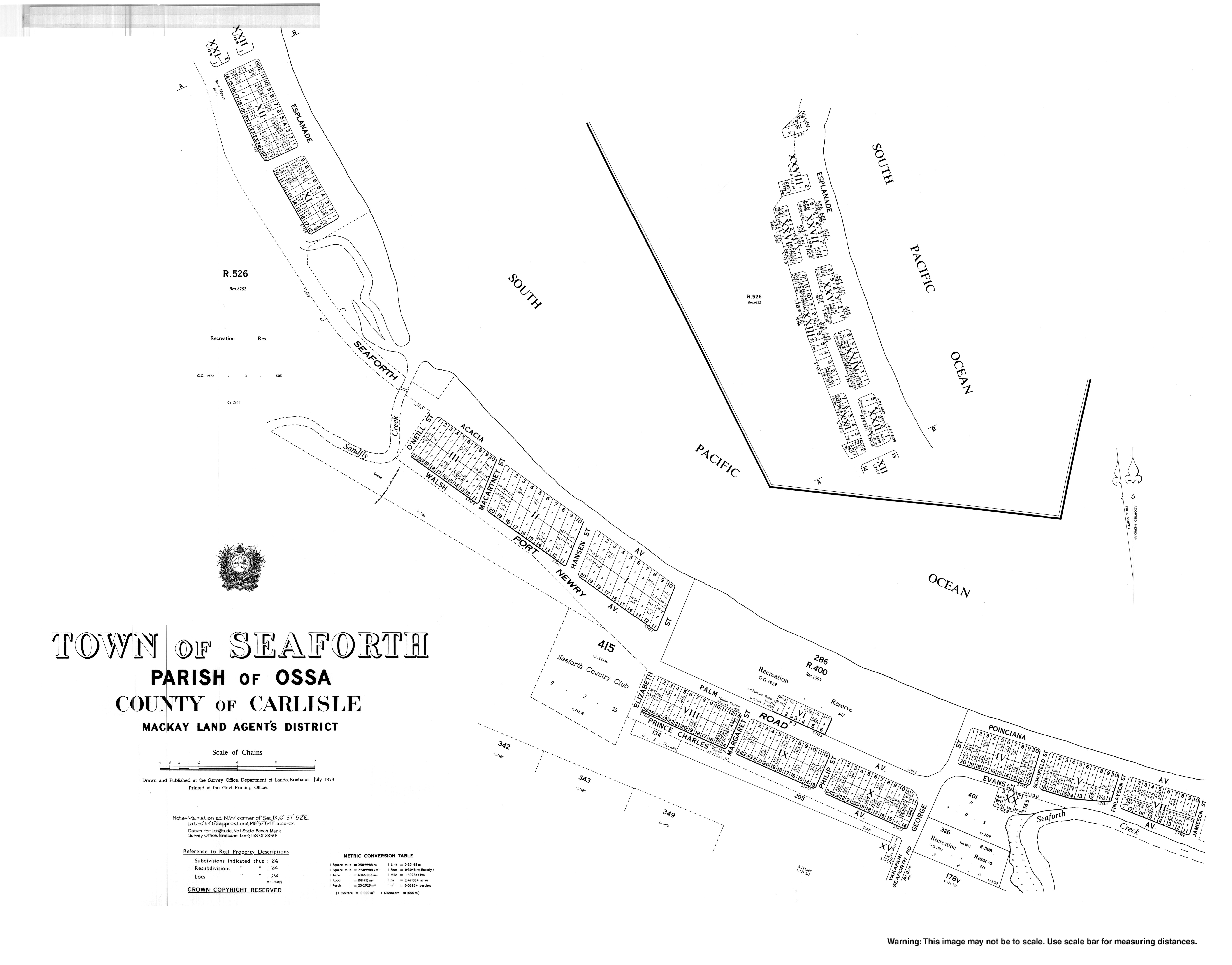
- "Town map of Seaforth". Queensland Government. 1973.
- "Seaforth: Detailed History". Hibiscus Coast Progress & Sports Association. Archived from the original on 7 March 2021.
Другой контент может иметь иную лицензию. Перед использованием материалов сайта WikiSort.org внимательно изучите правила лицензирования конкретных элементов наполнения сайта.
WikiSort.org - проект по пересортировке и дополнению контента Википедии