world.wikisort.org - Australia
Campwin Beach is a coastal town and rural locality in the Mackay Region, Queensland, Australia.[2][3] In the 2016 census, Campwin Beach had a population of 517 people.[1]
| Campwin Beach Queensland | |||||||||||||||
|---|---|---|---|---|---|---|---|---|---|---|---|---|---|---|---|
 Campwin Beach | |||||||||||||||
| Coordinates | 21.375°S 149.3152°E | ||||||||||||||
| Population | 517 (2016 census)[1] | ||||||||||||||
| • Density | 287/km2 (744/sq mi) | ||||||||||||||
| Postcode(s) | 4737 | ||||||||||||||
| Area | 1.8 km2 (0.7 sq mi) | ||||||||||||||
| Time zone | AEST (UTC+10:00) | ||||||||||||||
| Location |
| ||||||||||||||
| LGA(s) | Mackay Region | ||||||||||||||
| State electorate(s) | Mirani | ||||||||||||||
| Federal division(s) | Capricornia | ||||||||||||||
| |||||||||||||||
Geography
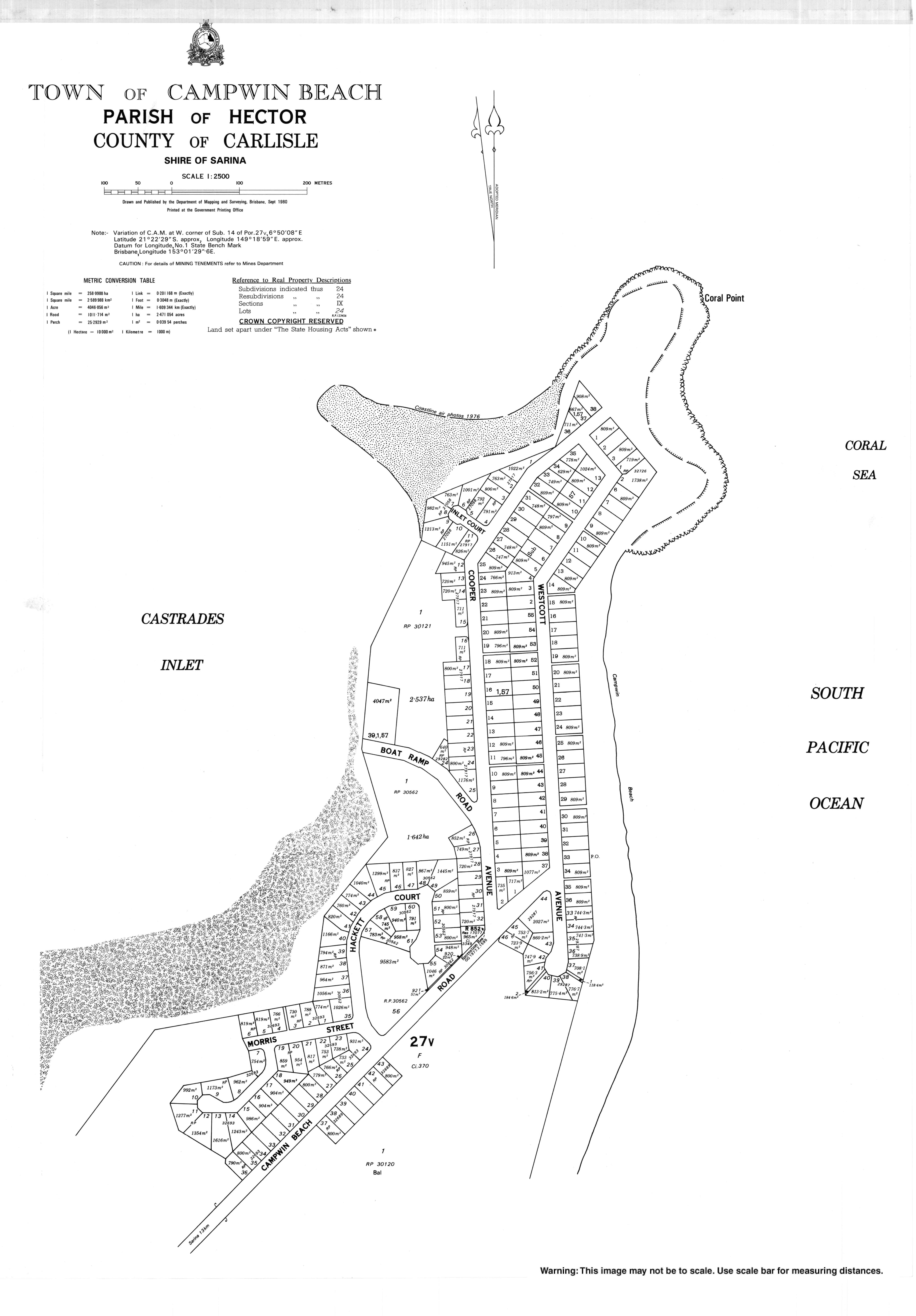
The J-shaped locality is bounded by the Coral Sea to the east, the Castrades Inlet (21.37611°S 149.3100°E) to the north-west, and loosely by an unnamed creek to the west.[4][5]
The headland in the north-east has Coral Point (21.3692°S 149.3181°E) as its northernmost point.[6] The headland area has a rocky coast with Coral Point Reef (21.3721°S 149.3194°E) just off the north-east coast of the locality. Campwin Beach is a sand beach to the south of the rocky headland (21.3749°S 149.3165°E) and is accessible to the public via Campwin Esplanade.[4]
The north-east of the locality is residential (the town) while the southern part is occupied by the Campwin Beach Prawn Farm (21.3825°S 149.3048°E). Much of land alongside Castrades Inlet is marshland and undeveloped (21.3772°S 149.3024°E).[4]
History
The original owners of the land were businessman James Campbell and William Winter and the town name is a combination of their surnames. The town was officially named and bounded on 30 January 2009,[2] but name was in use earlier since at least 1930.[7]
In the 2016 census, Campwin Beach had a population of 517 people.[1]
Economy
The Campwin Bay prawn farm typically yields 70 to 100 tonnes (77 to 110 tons) of prawns each year, which are cooked on site and auctioned through the Sydney Fish Market.[8]
Amenities
There is a boat ramp into the Castrades Inlet at the end of Campwin Beach Boat Ramp Road (21.3744°S 149.312702°E).[4][9]
Education
There are no schools in the locality. The nearest primary school is Alligator Creek State School at Alligator Creek to the north-west. The nearest secondary school is Sarina State High School in Sarina to the south-west.[4]
References
- Australian Bureau of Statistics (27 June 2017). "Campwin Beach (SSC)". 2016 Census QuickStats. Retrieved 20 October 2018.
- "Campwin Beach – town in Mackay Region (entry 6004)". Queensland Place Names. Queensland Government. Retrieved 18 September 2020.
- "Campwin Beach – locality in Mackay Region (entry 46768)". Queensland Place Names. Queensland Government. Retrieved 18 September 2020.
- "Queensland Globe". State of Queensland. Retrieved 21 October 2020.
- "Castrades Inlet – inlet in Mackay Region (entry 6480)". Queensland Place Names. Queensland Government. Retrieved 21 October 2020.
- "Coral Point – point in Mackay Region (entry 8418)". Queensland Place Names. Queensland Government. Retrieved 21 October 2020.
- "THE YOUNG FOLK". The Australasian. Vol. CXXIX, no. 4, 274. Victoria, Australia. 6 December 1930. p. 54 (METROPOLITAN EDITION). Archived from the original on 13 June 2022. Retrieved 21 October 2020 – via National Library of Australia.
- "Mackay Mini Tornado". Austasia Aquaculture. 25 (2): 18–19. Winter 2011.
- "Recreational Boating Facilities Queensland". Open Data Portal. Queensland Government. 27 March 2020. Archived from the original on 22 October 2020. Retrieved 21 October 2020.
External links
Другой контент может иметь иную лицензию. Перед использованием материалов сайта WikiSort.org внимательно изучите правила лицензирования конкретных элементов наполнения сайта.
WikiSort.org - проект по пересортировке и дополнению контента Википедии