world.wikisort.org - Australia
Gunalda is a rural town in the Gympie Region and a locality split between Gympie Region and Fraser Coast Region in Queensland, Australia.[2][3][4] In the 2016 census, the locality of Gunalda had a population of 392 people.[1]
| Gunalda Queensland | |||||||||||||||
|---|---|---|---|---|---|---|---|---|---|---|---|---|---|---|---|
 Gunalda Hotel | |||||||||||||||
 Gunalda | |||||||||||||||
| Coordinates | 25.9944°S 152.5613°E | ||||||||||||||
| Population | 392 (2016 census)[1] | ||||||||||||||
| • Density | 5.825/km2 (15.086/sq mi) | ||||||||||||||
| Postcode(s) | 4570 | ||||||||||||||
| Area | 67.3 km2 (26.0 sq mi) | ||||||||||||||
| Time zone | AEST (UTC+10:00) | ||||||||||||||
| Location |
| ||||||||||||||
| LGA(s) | |||||||||||||||
| State electorate(s) | Gympie | ||||||||||||||
| Federal division(s) | Wide Bay | ||||||||||||||
| |||||||||||||||
Geography
The town is 196 kilometres (122 mi) from the state capital, Brisbane.
The Bruce Highway runs through from south-west to north.[5]
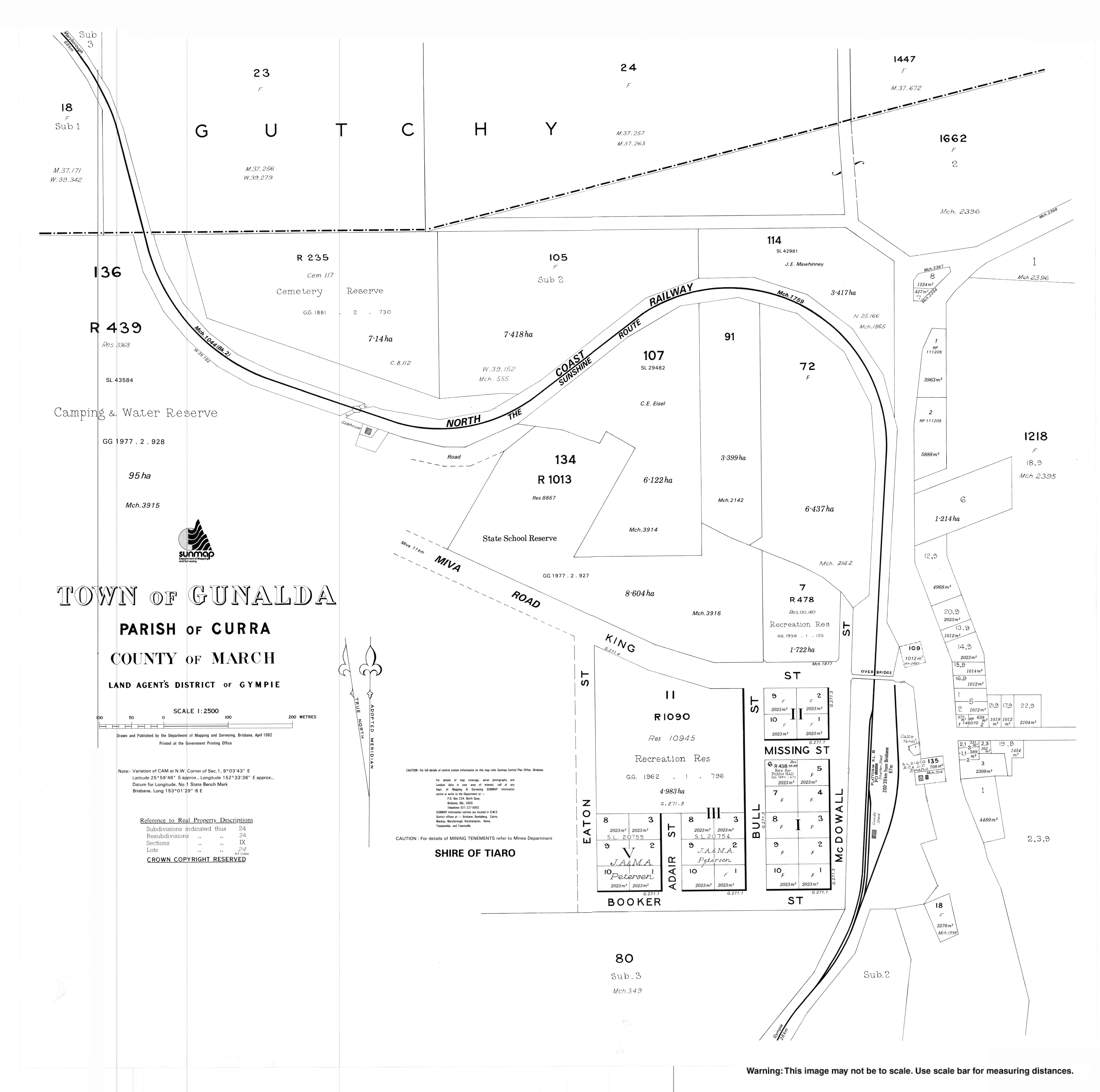
The North Coast railway line enters the locality from the south-west (Curra) and passes to the west of the town and exists to the north-west (Theebine).[6] Previously the railway line passed through the town,[7] which was served by the now-dismantled Gunalda railway station (25.9943°S 152.5620°E).[8]
History
Thompson's Flat Provisional School opened on 8 August 1881. In 1889, the school was renamed Gunalda Provisional School. On 1 January 1909, it became Gunalda State School.[9]
Eaton Post Office opened on 1 September 1882 and was renamed Gunalda in 1883.[10]
The town was originally called Keelar but after the railway station was named Gunalda on 2 November 1923, the town was renamed Gunalda.[2]
In December 1938, the foundation stone was laid for a Catholic church. On Sunday 8 October 1939, Archbishop James Duhig officially opened and dedicated the Catholic Church of the Little Flower.[11]
In 1947, Christ Church Anglican was relocated from Munna Creek to 11 King Street (25.9934°S 152.5613°E) in Gunalda where it retained the name Christ Church Anglican.[12][13]
At the 2006 census, Gunalda and the surrounding area had a population of 574.[14]
In the 2016 census, the locality of Gunalda had a population of 392 people.[1]
Education
Gunalda State School is a government primary (Prep-6) school for boys and girls at King Street (25.9927°S 152.5604°E).[15][16] In 2018, the school had an enrolment of 35 students with 3 teachers (2 full-time equivalent) and 5 non-teaching staff (3 full-time equivalent).[17]
There are no secondary schools in Gunalda. The nearest government secondary school is James Nash State High School in Gympie to the south-east.[6]
Facilities
Gunalda Cemetery is on the western end of Cotter Drive (25.9875°S 152.5553°E).[18]
References
- Australian Bureau of Statistics (27 June 2017). "Gunalda (SSC)". 2016 Census QuickStats. Retrieved 20 October 2018.
- "Gunalda – town in Gympie Region (entry 15054)". Queensland Place Names. Queensland Government. Retrieved 21 June 2017.
- "Gunalda – locality in Gympie Region (entry 49520)". Queensland Place Names. Queensland Government. Retrieved 21 June 2017.
- "Gunalda – locality in the Fraser Coast Region (entry 46740)". Queensland Place Names. Queensland Government. Retrieved 21 June 2017.
- Google (20 August 2021). "Gunalda, Queensland" (Map). Google Maps. Google. Retrieved 20 August 2021.
- "Queensland Globe". State of Queensland. Retrieved 19 June 2022.
- "Town of Gunalda" (Map). Queensland Government. 1982. Archived from the original on 20 June 2022. Retrieved 20 June 2022.
- "Railway stations and sidings - Queensland". Queensland Open Data. Queensland Government. 2 October 2020. Archived from the original on 5 October 2020. Retrieved 5 October 2020.
- Queensland Family History Society (2010), Queensland schools past and present (Version 1.01 ed.), Queensland Family History Society, ISBN 978-1-921171-26-0
- Premier Postal History. "Post Office List". Premier Postal Auctions. Archived from the original on 15 May 2014. Retrieved 10 May 2014.
- "NEW CHURCH AT GUNALDA". Maryborough Chronicle, Wide Bay and Burnett Advertiser. No. 21, 182. Queensland, Australia. 30 September 1939. p. 8. Archived from the original on 19 June 2022. Retrieved 31 August 2020 – via National Library of Australia.
- "Closed Churches". Anglican Church of Southern Queensland. Archived from the original on 3 April 2019. Retrieved 24 February 2019.
{{cite web}}: CS1 maint: unfit URL (link) - "Christ Church Anglican Church". Churches Australia. Archived from the original on 31 August 2020. Retrieved 31 August 2020.
- Australian Bureau of Statistics (25 October 2007). "Gunalda (Tiaro Shire) (State Suburb)". 2006 Census QuickStats. Retrieved 7 December 2010.
- "State and non-state school details". Queensland Government. 9 July 2018. Archived from the original on 21 November 2018. Retrieved 21 November 2018.
- "Gunalda State School". Archived from the original on 17 March 2019. Retrieved 21 November 2018.
- "ACARA School Profile 2018". Australian Curriculum, Assessment and Reporting Authority. Archived from the original on 27 August 2020. Retrieved 28 January 2020.
- "Cemetery Areas - Queensland". Queensland Open Data. Queensland Government. 12 November 2020. Archived from the original on 15 November 2020. Retrieved 12 November 2020.
Другой контент может иметь иную лицензию. Перед использованием материалов сайта WikiSort.org внимательно изучите правила лицензирования конкретных элементов наполнения сайта.
WikiSort.org - проект по пересортировке и дополнению контента Википедии