world.wikisort.org - Australia
Gloucester Island is a national park in Queensland, Australia, 950 km northwest of Brisbane.[1][2] It is visible from the town of Bowen. The island was seen and erroneously named "Cape Gloucester" by British explorer James Cook in 1770.[3] The name "Cape Gloucester" has been used informally for areas on or near Gloucester Island.
| Gloucester Island National Park Queensland | |
|---|---|
IUCN category II (national park) | |
 Gloucester Island | |
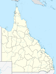  Gloucester Island National Park | |
| Nearest town or city | Bowen |
| Coordinates | 20°00′55″S 148°27′18″E |
| Established | 1994 |
| Area | 29.60 km2 (11.43 sq mi) |
| Managing authorities | Queensland Parks and Wildlife Service |
| See also | Protected areas of Queensland |
Bird watching is topical from October to April, when thousands of migrating birds can be seen, especially waders.[4] The average altitude of the terrain is 34 meters.[5]
See also

- Protected areas of Queensland
References
- "About Gloucester Islands". Department of National Parks, Recreation, Sport and Racing. The State of Queensland. 8 October 2012. Retrieved 2 January 2015.
- Google (2 January 2015). "Distance from Gloucester Island to Brisbane" (Map). Google Maps. Google. Retrieved 2 January 2015.
- "Whitsundays national park islands: Nature, culture and history". Department of National Parks, Recreation, Sport and Racing. The State of Queensland. 19 October 2012. Retrieved 2 January 2015.
- "Things to do | Whitsunday national park islands". Parks and forests | Department of Environment and Science, Queensland. 27 August 2009. Retrieved 3 May 2022.
- "Gloucester Island National Park topographic map, elevation, relief". topographic-map.com. Retrieved 3 May 2022.
Australian places named on the First voyage of James Cook in 1770 | ||
|---|---|---|
| Victoria |  | |
| New South Wales |
| |
| Queensland |
| |
*Places where Cook landed | ||
 | This Queensland protected areas related article is a stub. You can help Wikipedia by expanding it. |
Текст в блоке "Читать" взят с сайта "Википедия" и доступен по лицензии Creative Commons Attribution-ShareAlike; в отдельных случаях могут действовать дополнительные условия.
Другой контент может иметь иную лицензию. Перед использованием материалов сайта WikiSort.org внимательно изучите правила лицензирования конкретных элементов наполнения сайта.
Другой контент может иметь иную лицензию. Перед использованием материалов сайта WikiSort.org внимательно изучите правила лицензирования конкретных элементов наполнения сайта.
2019-2026
WikiSort.org - проект по пересортировке и дополнению контента Википедии
WikiSort.org - проект по пересортировке и дополнению контента Википедии