world.wikisort.org - Australia
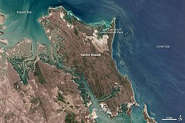
Curtis Island National Park is on Curtis Island, Queensland, Australia, in the Gladstone Region, 474 kilometres (295 mi) northwest of Brisbane and 40 kilometres (25 mi) southeast of Rockhampton.
| Curtis Island National Park Queensland | |
|---|---|
IUCN category II (national park) | |
 Curtis Island | |
 Curtis Island National Park | |
| Coordinates | 23°31′49″S 151°13′16″E |
| Established | 1909 |
| Area | 15.5 km2 (6.0 sq mi) |
| Managing authorities | Queensland Parks and Wildlife Service |
| Website | Curtis Island National Park |
| See also | Protected areas of Queensland |
The island features coastal heaths, littoral rainforest, sand dunes and beach ridges and salt flats.[1] The national park encompasses the Cape Capricorn headland.
No facilities are provided for campers. Bush camping is permitted in three camp grounds.
The island is home to a variety of bird species.[2]
The average elevation of the terrain is 16 meters.[3]
Heritage listings
Curtis Island has a number of heritage-listed sites, including:
- Sea Hill Point: Sea Hill Light[4]
See also
- Port of Gladstone
- Protected areas of Queensland
- Yellow chat
References
- "About Curtis Island". Department of National Parks, Recreation, Sport and Racing. 9 December 2010. Retrieved 10 July 2013.
- Science, jurisdiction=Queensland; sector=government; corporateName=Department of Environment and (4 March 2010). "Curtis Island National Park and Conservation Park". Parks and forests | Department of Environment and Science, Queensland. Retrieved 12 March 2022.
- "Curtis Island National Park topographic map, elevation, relief". topographic-map.com. Retrieved 13 March 2022.
- "Little Sea Hill Lighthouse (entry 602784)". Queensland Heritage Register. Queensland Heritage Council. Retrieved 11 July 2015.
This Queensland protected areas related article is a stub. You can help Wikipedia by expanding it. |
Текст в блоке "Читать" взят с сайта "Википедия" и доступен по лицензии Creative Commons Attribution-ShareAlike; в отдельных случаях могут действовать дополнительные условия.
Другой контент может иметь иную лицензию. Перед использованием материалов сайта WikiSort.org внимательно изучите правила лицензирования конкретных элементов наполнения сайта.
Другой контент может иметь иную лицензию. Перед использованием материалов сайта WikiSort.org внимательно изучите правила лицензирования конкретных элементов наполнения сайта.
2019-2025
WikiSort.org - проект по пересортировке и дополнению контента Википедии
WikiSort.org - проект по пересортировке и дополнению контента Википедии