world.wikisort.org - Australia
Clermont is a rural town and locality in the Isaac Region, Queensland, Australia.[2][3] At the 2021 census, the locality of Clermont had a population of 2952 people.[1]
| Clermont Queensland | |||||||||||||||
|---|---|---|---|---|---|---|---|---|---|---|---|---|---|---|---|
 Memorial marking the 1916 flood | |||||||||||||||
 Clermont | |||||||||||||||
| Coordinates | 22.8230°S 147.6383°E | ||||||||||||||
| Population | 2,952 (2021 census)[1] | ||||||||||||||
| • Density | 1.33454/km2 (3.4564/sq mi) | ||||||||||||||
| Established | 1864 | ||||||||||||||
| Postcode(s) | 4721 | ||||||||||||||
| Elevation | 267.0 m (876 ft) | ||||||||||||||
| Area | 2,212.0 km2 (854.1 sq mi) | ||||||||||||||
| Time zone | AEST (UTC+10:00) | ||||||||||||||
| Location |
| ||||||||||||||
| LGA(s) | Isaac | ||||||||||||||
| State electorate(s) | Burdekin | ||||||||||||||
| Federal division(s) | Capricornia | ||||||||||||||
| |||||||||||||||
| |||||||||||||||
Clermont is a major hub for the large coal mines in the region as well as serving agricultural properties.
Geography
Clermont is 274 kilometres (170 mi) south-west of Mackay on the junction of the Gregory and Peak Downs highways.
The historic towns of North Copperfield (22.8577°S 147.6046°E) and South Copperfield (22.8704°S 147.6027°E), often referred to collectively as Copperfield are along Christoe Street approximately 4 kilometres (2.5 mi) south-west of the Clermont town centre.[4]
The Gregory Highway runs through the eastern end, and the Peak Downs Highway enters from the east. The Clermont Connection Road links the Gregory Highway to the CBD, and the Clermont-Alpha Road starts in the CBD and exits to the south-west.[5]
History


Gangalu (Gangulu, Kangulu, Kanolu, Kaangooloo, Khangulu) is an Australian Aboriginal language spoken on Gangula country. The Gangula language region includes the towns of Clermont and Springsure extending south towards the Dawson River.[6]
Ludwig Leichhardt was the first European to pass through the Clermont area in 1845, but it was the discovery of gold in 1861 that was responsible for the establishment of the town, close to what was Babbinburra clan land. The town reserve was proclaimed on 25 March 1864, although a gold field was declared in the area in 1862.[7] Clermont is named after Clermont-Ferrand in France; Clermont-Ferrand was the ancestral home of Oscar de Satge, one of the first European graziers who owned the Wolfang Downs pastoral run.[8]
Theresa Creek Post Office opened by 1863, was replaced by Coppermines Post Office at the end of 1863 and Clermont Post Office in 1864.[9]
The first church in Clermont was a Catholic church opened on Sunday 4 November 1866 and dedicated to St Mary, Blessed Virgin of Sorrows.[10][11]
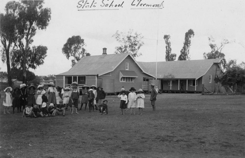
Clermont State School opened on 27 August 1867.[12][13][14]
A Congregational church opened in North Copperfield in November 1868.[15]
Copper was discovered soon after. In the 1880s up to 4000 Chinese people were resident in Clermont, mining for gold and copper. This led to racial riots and the Chinese were removed from the region in 1888. The decorated soldier Billy Sing was born in Clermont in 1886 of a Chinese father and English mother.
The Presbyterian Church in Clermont was formally re-opened on Sunday 10 June 1883.[16]
The railway was extended north from Emerald to Clermont in February 1884. However, no passenger trains are available to or from Clermont.
A Wesleyan Methodist Church opened in Clermont on the corner of Box Street and Capella Street on Sunday 19 September 1886. This is the site of the current Clermont Uniting Church, but the current church building was built circa 1970.[17][18][19]
The town was originally established on low-lying ground next to a lagoon or billabong, but flooding was always a problem, with four substantial floods occurring between 1864 and 1896.
St Joseph's School opened in January 1900.[20]
The greatest flood, in 1916, killed 65 people out of a town population of 1,500 and remains one of Australia's worst natural disasters in terms of life lost. Following the 1916 flood, many of the wooden buildings of the town were moved using steam traction engines to a new townsite on higher ground. A local amateur photographer, Gordon Pullar took numerous photographs of the moving buildings, published in the 1980s as "A Shifting Town".[21]
In the mid-1920s, The Capricornian newspaper refers to a Mr P. Matones (Matonez) as being one of the first owners of the Paris café in Clermont.[22] John (Jack) and Marouli (Monty) Faros took over the Café in the 1930s. It operated until 1992.[23]
The Clermont public library was opened in 1962.[24]
On 27 January 1959 a secondary department was added, Clermont State School providing secondary education (8-12). That arrangement ceased with the opening of Clermont State High School on 29 January 1990.[12][13][14][25]
Mistake Creek State School opened in the former locality of Mistake Creek on 24 January 1983.[26]
At the 2011 census, the town of Clermont had a population of 2,177.[27]
At the 2016 census, the locality of Clermont had a population of 3,031 people.[28]
On 17 May 2019, it was decided to discontinue the locality of Mistake Creek and absorb its land into the neighbouring localities of Clermont, Laglan, Frankfield and Peak Vale.[29][30][31]
At the 2021 census, the locality of Clermont had a population of 2952 people.[1]
Heritage listings
Clermont has a number of heritage-listed sites, including:
- Cemetery Road: Clermont Cemetery[32]
- 739 Fleurs Lane: Stone Farm Building[33]
- Oaky Creek, 20 kilometres (12 mi) West of Clermont on the Clermont-Alpha Road: Irlam's Ant Bed Building[34]
Coal mining
Glencore is currently operating the Clermont Mine, located 12 kilometres (7.5 mi) north west of Clermont.[35] When the mine reaches full capacity it will produce up to 12.2 million tonnes of thermal coal for international markets. Clermont Mine delivered its first conveyor of coal in April 2010.[36]
Clermont also hosted another larger coal mine; Blair Athol coal mine, located 20 kilometres (12 mi) north west of Clermont. The mine supplied customers in Asia and Europe with up to 12 million tonnes of thermal coal per annum. The coal deposit was originally discovered on the site in 1864[37] and was first mined in 1890. Between 1920 and 1945 coal was mined with an underground method, which is still visible today. The most recent open cut operation started in 1984. Blair Athol Mine was closed on 26 November 2012 after it completely mined out.[37] Its stockpile and train facilities will be used by the Clermont Mine.[37]
Education
Clermont State School is a government primary (Prep-6) school for boys and girls at Hetherington Street (22.8365°S 147.6321°E).[38][39] In 2017, the school had an enrolment of 237 students with 20 teachers (18 full-time equivalent) and 12 non-teaching staff (9 full-time equivalent).[40]
Clermont State High School is a government secondary (7-12) school for boys and girls at 1 Kitchener Street (22.8277°S 147.6389°E).[38][41] In 2017, the school had an enrolment of 182 students with 20 teachers and 15 non-teaching staff (11 full-time equivalent).[40]
St Joseph's Catholic Primary School is a Catholic primary (Prep-6) school for boys and girls at 50 Box Street (22.8220°S 147.6391°E).[38][42] In 2017, the school had an enrolment of 106 students with 10 teachers (9 full-time equivalent) and 6 non-teaching staff (3 full-time equivalent).[40]
Mistake Creek State School is a government primary (Prep-6) school for boys and girls at 6652 Alpha Road (22.9889°S 147.0833°E).[43][44] In 2017, the school had an enrolment of 14 students with 2 teachers and 2 non-teaching staff (1 full-time equivalent).[45] This school is within the former locality of Mistake Creek, which was discontinued and absorbed into neighbouring localities in May 2019; the school is now within the enlarged boundaries of the locality of Clermont.[4]
Amenities
The Isaac Regional Council operates a public library at the corner of Karmoo and Herschel Street.[46]
The Clermont branch of the Queensland Country Women's Association meets at the QCWA Rooms at 28 Sirus Street.[47]
Clermont Uniting Church is at 40 Box Street (corner of Capella Street, 22.8220°S 147.6409°E).[48][49]
Clermont aerodrome lies 3.5 nautical miles (6.5 km; 4.0 mi) north northeast of the town.
References
- "2021 Clermont, Census All persons QuickStats | Australian Bureau of Statistics". www.abs.gov.au. Retrieved 28 June 2022.
- "Clermont – town in Isaac Region (entry 7403)". Queensland Place Names. Queensland Government. Retrieved 20 July 2021.
- "Clermont – locality in Isaac Region (entry 50383)". Queensland Place Names. Queensland Government. Retrieved 20 July 2021.
- "Queensland Globe". State of Queensland. Retrieved 12 September 2021.
- Clermont, Queensland (Map). OpenStreetMap. Archived from the original on 7 April 2022. Retrieved 7 April 2022.
-
 This Wikipedia article incorporates CC-BY-4.0 licensed text from: "Gangalu". Queensland Aboriginal and Torres Strait Islander languages map. State Library of Queensland. Retrieved 23 January 2020.
- "Clermont". Isaac Regional Council. Archived from the original on 27 November 2012. Retrieved 11 April 2012.
- "Clermont". Did you know ... Isaac Regional Council. Archived from the original on 3 February 2014. Retrieved 23 January 2014.
- Premier Postal History. "Post Office List". Premier Postal Auctions. Archived from the original on 15 May 2014. Retrieved 10 May 2014.
- "CLERMONT". The Queenslander. Vol. I, no. 41. Queensland, Australia. 10 November 1866. p. 8. Archived from the original on 9 December 2021. Retrieved 12 September 2021 – via National Library of Australia.
- "PEAK DOWNS". Northern Argus. No. 457. Queensland, Australia. 17 September 1866. p. 4. Archived from the original on 9 December 2021. Retrieved 12 September 2021 – via National Library of Australia.
- "Opening and closing dates of Queensland Schools". Queensland Government. Retrieved 13 July 2014.
- Queensland Family History Society (2010), Queensland schools past and present (Version 1.01 ed.), Queensland Family History Society, ISBN 978-1-921171-26-0
- "Agency ID 5099, Clermont State School". Queensland State Archives. Retrieved 14 July 2014.
- "CLERMONT". The Queenslander. Vol. III, no. 146. Queensland, Australia. 21 November 1868. p. 5. Archived from the original on 9 December 2021. Retrieved 12 September 2021 – via National Library of Australia.
- "The Morning Bulletin, ROCKHAMPTON". Morning Bulletin. Vol. XXX, no. 4751. Queensland, Australia. 18 June 1883. p. 2. Archived from the original on 31 August 2021. Retrieved 12 September 2021 – via National Library of Australia.
- "CLERMONT". Morning Bulletin. Vol. XXXIV, no. 4744. Queensland, Australia. 1 October 1886. p. 5. Archived from the original on 9 December 2021. Retrieved 12 September 2021 – via National Library of Australia.
- Blake, Thom. "Clermont Wesleyan Methodist Church". Queensland religious places database. Archived from the original on 11 September 2021. Retrieved 11 September 2021.
- Blake, Thom. "Clermont Methodist Church". Queensland religious places database. Archived from the original on 11 September 2021. Retrieved 11 September 2021.
- Queensland Family History Society (2010), Queensland schools past and present (Version 1.01 ed.), Queensland Family History Society, ISBN 978-1-921171-26-0
- Stringer, Marguerite; Stringer, Richard (1 January 1986), A shifting town : glass plate images of Clermont and its people by G. C. Pullar, University of Queensland Press, archived from the original on 11 September 2021, retrieved 29 December 2015
- "CLERMONT". The Capricornian. Queensland, Australia. 7 November 1925. p. 9. Archived from the original on 11 September 2021. Retrieved 5 February 2020 – via Trove.
-
 This Wikipedia article incorporates text from Paris Cafe, Clermont (14 December 2019) published by the State Library of Queensland under CC-BY licence, accessed on 5 February 2020.
- "Public Libraries Statistical Bulletin 2016-17" (PDF). Public Libraries Connect. State Library of Queensland. November 2017. p. 13. Archived (PDF) from the original on 30 January 2018. Retrieved 15 January 2018.
- "Agency ID 8836, Clermont State High School". Queensland State Archives. Retrieved 14 July 2014.
- "Opening and closing dates of Queensland Schools". Queensland Government. Retrieved 18 April 2019.
- Australian Bureau of Statistics (31 October 2012). "Clermont (Urban Centre)". 2011 Census QuickStats. Retrieved 31 July 2013.
- Australian Bureau of Statistics (27 June 2017). "Clermont (SSC)". 2016 Census QuickStats. Retrieved 20 October 2018.
- "Recent place name decisions". Queensland Government. 14 June 2019. Archived from the original on 7 July 2019. Retrieved 27 October 2019.
{{cite web}}: CS1 maint: unfit URL (link) - "Proposed Locality Boundaries and Names of Isaac Regional Council: Clermont, Laglan, Frankfield and Peak Vale, Central Highlands Regional Council: Argyll and Peak Vale" (PDF). Department of Natural Resources, Mines and Energy. Queensland Government. 23 November 2018. Archived from the original (PDF) on 27 October 2019. Retrieved 27 October 2019.
- "Locality Boundaries and Names of Isaac Regional Council: Clermont, Laglan, Frankfield and Peak Vale, Central Highlands Regional Council: Argyll and Peak Vale" (PDF). Department of Natural Resources, Mines and Energy. Queensland Government. 17 May 2019. Archived from the original (PDF) on 28 July 2019. Retrieved 27 October 2019.
- "Clermont Cemetery (entry 602756)". Queensland Heritage Register. Queensland Heritage Council. Retrieved 10 July 2013.
- "Stone Farm Building (entry 602555)". Queensland Heritage Register. Queensland Heritage Council. Retrieved 10 July 2013.
- "Irlam's Ant Bed Building (former) (entry 602010)". Queensland Heritage Register. Queensland Heritage Council. Retrieved 10 July 2013.
- Chambers, Matt (26 October 2013). "Glencore buys Rio's Clermont for $1bn". The Australian. Archived from the original on 29 October 2013. Retrieved 1 June 2014.
- MacDonald, C 2010. Clermont mine delivers first conveyor of coal Archived 6 July 2011 at the Wayback Machine. The Australian Bulk Handling Review. Retrieved on 11 April 2012.
- Melissa Maddison; Paul Robinson (26 November 2012). "Sun goes down on Blair Athol mine". ABC News. Australian Broadcasting Corporation. Archived from the original on 26 November 2012. Retrieved 31 July 2013.
- "State and non-state school details". Queensland Government. 9 July 2018. Archived from the original on 21 November 2018. Retrieved 21 November 2018.
- "Clermont State School". Archived from the original on 20 April 2013. Retrieved 21 November 2018.
- "ACARA School Profile 2017". Archived from the original on 22 November 2018. Retrieved 22 November 2018.
- "Clermont State High School". Archived from the original on 22 February 2013. Retrieved 21 November 2018.
- "St Joseph's Catholic Primary School". Archived from the original on 8 February 2019. Retrieved 21 November 2018.
- "State and non-state school details". Queensland Government. 9 July 2018. Archived from the original on 21 November 2018. Retrieved 21 November 2018.
- "Mistake Creek State School". Archived from the original on 26 March 2020. Retrieved 21 November 2018.
- "ACARA School Profile 2017". Archived from the original on 22 November 2018. Retrieved 22 November 2018.
- "Clermont Library". Public Libraries Connect. State Library of Queensland. 21 June 2017. Archived from the original on 15 January 2018. Retrieved 15 January 2018.
- "Branch Locations". Queensland Country Women's Association. Archived from the original on 26 December 2018. Retrieved 26 December 2018.
- "Find a Church". Uniting Church in Australia, Queensland Synod. Archived from the original on 24 October 2020. Retrieved 22 November 2020.
- "Clermont Capella Congregations of the Uniting Church in Australia". Archived from the original on 31 August 2021. Retrieved 11 September 2021.
Further reading
- Pullar, G. C. (Gordon Cumming); Stringer, Marguerite, 1942-; Stringer, Richard, 1936- (1986), A shifting town : glass-plate images of Clermont and its people by G.C. Pullar, University of Queensland Press, ISBN 978-0-7022-2012-8
{{citation}}: CS1 maint: multiple names: authors list (link) — full text available online
External links
- "Town map of Clermont". Queensland Government. 1988.
Authority control | |
|---|---|
| General | |
| National libraries | |
На других языках
[de] Clermont (Queensland)
Clermont ist eine Kleinstadt, die sich in der Isaac Region, Queensland in Australien befindet. Sie liegt 274 km südwestlich von Mackay an der Kreuzung des Gregory Highway und Peak Downs Highway.- [en] Clermont, Queensland
[ru] Клермонт (Квинсленд)
Клермонт (англ. Clermont) — город, находящийся в районе Айзак, восточный Квинсленд, Австралия.Другой контент может иметь иную лицензию. Перед использованием материалов сайта WikiSort.org внимательно изучите правила лицензирования конкретных элементов наполнения сайта.
WikiSort.org - проект по пересортировке и дополнению контента Википедии