world.wikisort.org - Australia
The County of Croajingolong is one of the 37 counties of Victoria which are part of the cadastral divisions of Australia, used for land titles. It is the most easterly county, and includes the Croajingolong National Park. Its western boundary is the Snowy River. The county was proclaimed in 1871 together with others from the Gipps Land District. Some time earlier maps showed proposed counties of Howe and Combermere occupying the area of Croajingolong.
| Croajingolong Victoria | |||||||||||||||
|---|---|---|---|---|---|---|---|---|---|---|---|---|---|---|---|
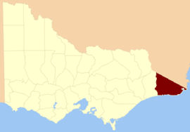 Location in Victoria | |||||||||||||||
| Established | 24 February 1871 | ||||||||||||||
| Area | 8,830 km2 (3,409.3 sq mi) | ||||||||||||||
| |||||||||||||||

Parishes
Parishes include:
- Baawang, Victoria
- Barga, Victoria
- Bemm, Victoria
- Bendock, Victoria
- Betka, Victoria
- Bidwell, Victoria
- Bonang, Victoria
- Bondi, Victoria
- Boorpuk, Victoria
- Bralak, Victoria
- Brindat, Victoria
- Bullamalk, Victoria
- Bungywarr, Victoria
- Cabanandra, Victoria
- Cobon, Victoria
- Combienbar, Victoria
- Cooaggalah, Victoria
- Coopracambra, Victoria
- Curlip, Victoria
- Deddick, Victoria
- Dellicknora, Victoria
- Derndang, Victoria
- Errinundra, Victoria
- Gabo, Victoria
- Goolengook, Victoria
- Goongerah, Victoria
- Jilwain, Victoria
- Jingallala, Victoria
- Jirrah, Victoria
- Karlo, Victoria
- Kirkenong, Victoria
- Koola, Victoria
- Kooragan, Victoria
- Kowat, Victoria
- Kuark, Victoria
- Loomat, Victoria
- Loongelaat, Victoria
- Mallacoota, Victoria
- Maramingo, Victoria
- Moonkan, Victoria
- Murrungowar, Victoria
- Nerran, Victoria
- Noonga, Victoria
- Noorinbee, Victoria
- Nungal, Victoria
- Orbost, Victoria
- Orbost East, Victoria
- Pinnak, Victoria
- Purgagoolah, Victoria
- Tabbara, Victoria
- Tamboon, Victoria
- Thurra, Victoria
- Tingaringy, Victoria
- Tonghi, Victoria
- Toonyarak, Victoria
- Tubbut, Victoria
- Wangarabell, Victoria
- Wat Wat, Victoria
- Wau Wauka, Victoria
- Wau Wauka West, Victoria
- Weeragua, Victoria
- Wibenduck, Victoria
- Wingan, Victoria
- Winyar, Victoria
- Wooyoot, Victoria
- Wurrin, Victoria
- Wyangil, Victoria
- Yalmy, Victoria
- Yarak, Victoria
References
- Vicnames, place name details
- Research aids, Victoria 1910
- Map of the counties of Benambra, Tambo, Croajingolong and Dargo in Victoria showing county boundaries, parish boundaries, main roads, telegraph lines and railways. 1886, J. Sands. National Library of Australia
Текст в блоке "Читать" взят с сайта "Википедия" и доступен по лицензии Creative Commons Attribution-ShareAlike; в отдельных случаях могут действовать дополнительные условия.
Другой контент может иметь иную лицензию. Перед использованием материалов сайта WikiSort.org внимательно изучите правила лицензирования конкретных элементов наполнения сайта.
Другой контент может иметь иную лицензию. Перед использованием материалов сайта WikiSort.org внимательно изучите правила лицензирования конкретных элементов наполнения сайта.
2019-2026
WikiSort.org - проект по пересортировке и дополнению контента Википедии
WikiSort.org - проект по пересортировке и дополнению контента Википедии