world.wikisort.org - Australia
The County of Borung is one of the 37 counties of Victoria which are part of the cadastral divisions of Australia, used for land titles. The northern boundary of the county is at 36°S. At the north its western boundary is 142°E, its eastern boundary is 143°E. Larger towns include Dimboola, Warracknabeal, Horsham and Stawell. The county was proclaimed in 1871 together with the other counties of the Wimmera Land District. The county was proclaimed in 1871.
| Borung Victoria | |||||||||||||||
|---|---|---|---|---|---|---|---|---|---|---|---|---|---|---|---|
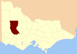 Location in Victoria | |||||||||||||||
| |||||||||||||||
Parishes
Parishes within the county:
- Ararat (part in the County of Ripon)
- Areegra
- Ashens
- Bangerang
- Batchica
- Batyik
- Bellaura
- Bellellen
- Beyal
- Boreang East (part in the County of Dundas)
- Boreang West (part in the County of Dundas)
- Boroka
- Bulgana (part in the County of Ripon)
- Bungalally
- Burrong North
- Burrong South
- Burrum Burrum (part in the County of Kara Kara)
- Callawadda (part in the County of Kara Kara)
- Cannum
- Carron
- Concongella
- Concongella South (part in the County of Ripon)
- Corack
- Dimboola (part in the County of Lowan)
- Dollin (part in the County of Lowan)
- Dooen
- Drung Drung
- Dunmunkle
- Dunneworthy (part in the County of Ripon)
- Gampola
- Glenorchy
- Glynwylln (part in the County of Kara Kara)
- Golton Golton
- Hindmarsh
- Horsham
- Illawarra
- Jallukar
- Jeparit
- Joop
- Jung Jung
- Kalkee
- Kalymna (part in the County of Ripon)
- Katyil
- Kellalac
- Kewell East
- Kewell West
- Kirkella
- Knaawing
- Laen
- Lah-arum
- Lallat
- Ledcourt
- Lexington (part in the County of Ripon)
- Longerenong
- Marma
- Mockinya (part in the County of Lowan)
- Mokepilly
- Mount Cole (parts in the County of Kara Kara and County of Ripon)
- Moyston
- Moyston West
- Narraport
- Nullan
- Quantong
- Riachella
- Rich Avon East (part in the County of Kara Kara)
- Rich Avon West
- Rupanyup
- Stawell
- Tarranyurk
- Vectis East
- Wallup
- Warmur
- Warracknabeal
- Warrak (part in the County of Kara Kara)
- Warranook
- Warra Warra
- Wartook
- Warung
- Watchem
- Watta Wella
- Werrigar
- Wilkur
- Willam
- Willenabrina
- Wirchilleba (part in the County of Kara Kara)
- Witchipool
- Wonwondah
- Yellangip
- [1]
References
- Rootsweb Genealogy, Victorian Counties, retrieved 20 September 2008
- Research aids, Victoria 1910
- Map of the counties of Lowan, Borung and Kara Kara showing colony and parish boundaries, main roads, telegraph lines and railways. 1886. National Library of Australia
This article about a location in Victoria, Australia is a stub. You can help Wikipedia by expanding it. |
Текст в блоке "Читать" взят с сайта "Википедия" и доступен по лицензии Creative Commons Attribution-ShareAlike; в отдельных случаях могут действовать дополнительные условия.
Другой контент может иметь иную лицензию. Перед использованием материалов сайта WikiSort.org внимательно изучите правила лицензирования конкретных элементов наполнения сайта.
Другой контент может иметь иную лицензию. Перед использованием материалов сайта WikiSort.org внимательно изучите правила лицензирования конкретных элементов наполнения сайта.
2019-2026
WikiSort.org - проект по пересортировке и дополнению контента Википедии
WikiSort.org - проект по пересортировке и дополнению контента Википедии