world.wikisort.org - Australia
Corowa Shire was a local government area in the Riverina region in southern New South Wales, Australia. The area was located adjacent to the Murray River and the Riverina Highway.
| Corowa Shire New South Wales | |||||||||||||||
|---|---|---|---|---|---|---|---|---|---|---|---|---|---|---|---|
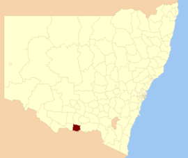 Location in New South Wales | |||||||||||||||
| Coordinates | 35°59′S 146°23′E | ||||||||||||||
| Population | 11,383 (2012)[1] | ||||||||||||||
| • Density | 4.8875/km2 (12.659/sq mi) | ||||||||||||||
| Established | 1955 | ||||||||||||||
| Abolished | 2016 | ||||||||||||||
| Area | 2,329 km2 (899.2 sq mi) | ||||||||||||||
| Council seat | Corowa[2] | ||||||||||||||
| Region | Riverina | ||||||||||||||
| State electorate(s) | Albury | ||||||||||||||
| Federal division(s) | Division of Farrer | ||||||||||||||
| Website | Corowa Shire | ||||||||||||||
| |||||||||||||||
The Shire included the towns of Corowa, Howlong, Balldale, Coreen and Daysdale, Rennie and Mulwala.
It was established in 1955 through a merger of the Corowa Municipality and Coreen Shire.[3]
Amalgamation
A 2015 review of local government boundaries by the NSW Government Independent Pricing and Regulatory Tribunal recommended that the Corowa Shire merge with the Lockhart and Urana shires to form a new council with an area of 8,581 square kilometres (3,313 sq mi) and support a population of approximately 16,000.[4] The council was dissolved on 12 May 2016 and along with Urana Shire the area became part of the new Federation Council[5]
Council

Composition and election method
At the time of dissolution, Corowa Shire Council was composed of nine councillors elected proportionally as a single ward. All councillors were elected for a fixed four-year term of office. The last election was due to be held on 8 September 2012. However, only nine candidates, being the below, nominated for election. There being no additional candidates, the election was uncontested.[6]
References
- Australian Bureau of Statistics (30 March 2010). "Regional Population Growth, Australia, 2008–09". Archived from the original on 5 June 2010. Retrieved 3 June 2010.
- "Corowa Shire Council". Department of Local Government. Retrieved 8 November 2006.
- "History & Heritage". Corowa Shire Council. Federation Council. Retrieved 21 May 2016.
- "Merger proposal: Corowa Shire Council, Lockhart Shire Council, Urana Shire Council" (PDF). Government of New South Wales. January 2016. p. 8. Retrieved 13 March 2016.
- "Federation Council". Stronger Councils. Government of New South Wales. 12 May 2016. Retrieved 13 May 2016.
- "No council vote in some Riverina shires". ABC News. Australia. 10 August 2012. Retrieved 2 October 2012.
| Authority control |
|
|---|
Другой контент может иметь иную лицензию. Перед использованием материалов сайта WikiSort.org внимательно изучите правила лицензирования конкретных элементов наполнения сайта.
WikiSort.org - проект по пересортировке и дополнению контента Википедии