world.wikisort.org - Angola
Catumbela is a city and municipality of the Benguela province in Angola. The municipality had a population of 175,805 in 2014.[1]
Catumbela | |
|---|---|
Municipality and town | |
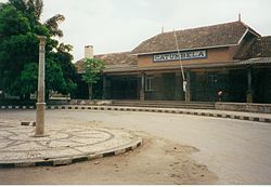
 Catumbela railway station | |
 Catumbela Location in Angola | |
| Coordinates: 12°26′2.1″S 13°32′35.7″E | |
| Country | |
| Province | Benguela Province |
| Government | |
| • Mayor | Filomena Pascoal |
| Area | |
| • Municipality and town | 801 km2 (309 sq mi) |
| Population (2014 Census)[1] | |
| • Municipality and town | 175,805 |
| • Density | 220/km2 (570/sq mi) |
| • Urban | 95,034 |
| Time zone | UTC+1 (WAT) |
History
In the late 18th and early 19th centuries, the Portuguese built Forte de São Pedro to establish themselves in Benguela. Today, the fort is in a dilapidated condition, but plans are being made to restore it and turn it into a museum.[3]
Catumbela was a commune in the municipality of Lobito until 2011, when it became a municipality in its own right.[4][5]
Transport
Catumbela is served by a station on the national railway network as well as Catumbela Airport.[6]
See also
- Railway stations in Angola
References
Wikimedia Commons has media related to Catumbela.
- "Resultados Definitivos Recenseamento Geral da População e Habitação – 2014 Província de Benguela" (PDF). Instituto Nacional de Estatística, República de Angola. Archived from the original (PDF) on 1 November 2020. Retrieved 3 May 2020.
- Citypopulation.de Population of cities & urban localities in Angola
- "Governante defende reabilitação do Forte de São Pedro". Agência Angola Press (in Portuguese). 8 September 2010. Archived from the original on 4 March 2016. Retrieved 9 June 2015.
- "Governador aponta importância da ascensão da comuna da Catumbela a município". Agência Angola Press (in Portuguese). 25 October 2011. Archived from the original on 4 March 2016. Retrieved 9 June 2015.
- "Município da Catumbela ganha nova escola primária". Agência Angola Press (in Portuguese). 13 December 2012. Archived from the original on 4 March 2016. Retrieved 9 June 2015.
- "Angola's Catumbela airport an alternative to Luanda". Macauhub. 28 August 2012. Archived from the original on 2015-01-04. Retrieved 9 June 2015.
На других языках
- [en] Catumbela
[ru] Катумбела
Катумбела (порт. Catumbela) — город и муниципалитет в провинции Бенгела в Анголе.Текст в блоке "Читать" взят с сайта "Википедия" и доступен по лицензии Creative Commons Attribution-ShareAlike; в отдельных случаях могут действовать дополнительные условия.
Другой контент может иметь иную лицензию. Перед использованием материалов сайта WikiSort.org внимательно изучите правила лицензирования конкретных элементов наполнения сайта.
Другой контент может иметь иную лицензию. Перед использованием материалов сайта WikiSort.org внимательно изучите правила лицензирования конкретных элементов наполнения сайта.
2019-2025
WikiSort.org - проект по пересортировке и дополнению контента Википедии
WikiSort.org - проект по пересортировке и дополнению контента Википедии