world.wikisort.org - Angola
Catabola is a town and municipality in Bié Province in central Angola.[3][4] It is located 52.5 kilometres (32.6 mi) by road northeast of Kuito, on the road to Camacupa. The municipality had a population of 126,631 in 2014.[1]
Catabola | |
|---|---|
Municipality and town | |
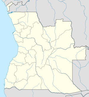  Catabola Location in Angola | |
| Coordinates: 12°7′S 17°18′E | |
| Country |  Angola Angola |
| Province | Bié Province |
| Area | |
| • Municipality and town | 1,103 sq mi (2,857 km2) |
| Population (2014 Census)[1] | |
| • Municipality and town | 126,631 |
| • Density | 110/sq mi (44/km2) |
| • Urban | 28,831 |
| Time zone | UTC+1 (WAT) |
| Climate | Cwb |
History
Before 1975 the main town was known as "Nova Sintra".[5] On 20 February 1996, the Forças Armadas de Angola (FAA) attacked a UNITA garrison in Lisusu, about 15 kilometres (9.3 mi) from Catabola.[6] It was captured along with towns such as Andulo, Bailundo, Camapuca and Chiguar during the FAA Christmas Offensive of December 1999.[7][8] Numerous local government officials and sympathizers of the government were killed during the attack.[7]
References
- "Resultados Definitivos Recenseamento Geral da População e Habitação – 2014 Província do Bié" (PDF). Instituto Nacional de Estatística, República de Angola. Retrieved 3 May 2020.
- Citypopulation.de Population of cities & urban localities in Angola
- "City councils of Angola". Statoids. Retrieved April 7, 2009.
- "Angola". Censo 2014. Retrieved 12 June 2018.
- Tropical health: a report on a study of needs and resources. National Research Council (U.S.). Division of Medical Academies. 1962. p. 151. NAP:14018.
- Daily Report. Africa (Sub-Sahara). Foreign Broadcast Information Service. 1996. p. 15.
- Vines, Alex (1999). Angola Unravels: The Rise and Fall of the Lusaka Peace Process. Human Rights Watch. p. 79. ISBN 978-1-56432-233-3.
- James, W. Martin (5 May 2011). Historical Dictionary of Angola. Scarecrow Press. p. 195. ISBN 978-0-8108-7458-9.
| Municipalities of Angola | |
|---|---|
| Bengo Province |
|
| Benguela Province |
|
| Bié Province | |
| Cabinda Province |
|
| Cuando Cubango Province | |
| Cuanza Norte Province |
|
| Cuanza Sul Province |
|
| Cunene Province |
|
| Huambo Province |
|
| Huíla Province | |
| Luanda Province |
|
| Lunda Norte Province | |
| Lunda Sul Province | |
| Malanje Province | |
| Moxico Province |
|
| Namibe Province | |
| Uíge Province | |
| Zaire Province |
|
| Bié Province | |
|---|---|
Capital: Kuito | |
| Andulo | |
| Camacupa |
|
| Catabola | |
| Chinguar |
|
| Chitembo | |
| Cuemba |
|
| Cunhinga |
|
| Kuito | |
| Nharea |
|
 | This Angola location article is a stub. You can help Wikipedia by expanding it. |
На других языках
- [en] Catabola
[ru] Катабола
Катабола (порт. Catabola) — муниципалитет в Анголе, входящий в провинцию Бие. Площадь 3028 км2, население на 2006 год — 224 802 человек. Плотность населения — 74,2 человек на 1 км2. Крупнейший город — Катабола с населением 23 362 человек[1].Текст в блоке "Читать" взят с сайта "Википедия" и доступен по лицензии Creative Commons Attribution-ShareAlike; в отдельных случаях могут действовать дополнительные условия.
Другой контент может иметь иную лицензию. Перед использованием материалов сайта WikiSort.org внимательно изучите правила лицензирования конкретных элементов наполнения сайта.
Другой контент может иметь иную лицензию. Перед использованием материалов сайта WikiSort.org внимательно изучите правила лицензирования конкретных элементов наполнения сайта.
2019-2026
WikiSort.org - проект по пересортировке и дополнению контента Википедии
WikiSort.org - проект по пересортировке и дополнению контента Википедии